Category:16 Ashville Road, Birkenhead
Jump to navigation
Jump to search
| Object location | | View all coordinates using: OpenStreetMap |
|---|
This is a category about listed building number 1282601. |
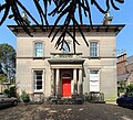
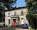
Grade II listed house in Birkenhead, Wirral, Merseyside, UK  | |||||
| Upload media | |||||
| Instance of | |||||
|---|---|---|---|---|---|
| Location | Birkenhead, Wirral, Merseyside, North West England, England | ||||
| Heritage designation |
| ||||
 | |||||
1840s two-storey house in Italianate style. Listing includes the gate piers.
Media in category "16 Ashville Road, Birkenhead"
The following 4 files are in this category, out of 4 total.
-
 16 Ashville Road, Birkenhead 2019-1.jpg 3,513 × 3,204; 8.34 MB
-
 16 Ashville Road, Birkenhead 2019-2.jpg 3,984 × 3,222; 9.87 MB
-
 16 Ashville Road, Birkenhead.jpg 4,472 × 3,296; 9.5 MB
-
 Gate piers of 16 Ashville Road, Birkenhead.jpg 5,145 × 3,447; 13.75 MB


