Category:1590s maps of Spain
Jump to navigation
Jump to search
Countries of Europe: Albania · Armenia‡ · Austria · Belgium · Bosnia and Herzegovina · Bulgaria · Croatia · Cyprus‡ · Denmark · Estonia · Finland · France‡ · Georgia‡ · Germany · Greece · Hungary · Iceland · Republic of Ireland · Italy · Lithuania · Netherlands‡ · Norway · Poland · Portugal‡ · Romania · Russia‡ · Spain‡ · Sweden · Turkey‡ · Ukraine
‡: partly located in Europe
‡: partly located in Europe
Media in category "1590s maps of Spain"
The following 9 files are in this category, out of 9 total.
-

-
 "Hispaniae regnum," 1597 closer view.jpg 800 × 600; 200 KB
-
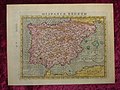 "Hispaniae regnum," 1597.jpg 800 × 600; 155 KB
-
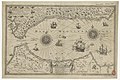
 EdwardWright-MapforSailingtoAzores-1599.jpg 477 × 518; 96 KB
-
-

-

-
 Península Ibérica em Thalassographica Tabula totius maris mediterranei (1594).jpg 2,808 × 2,039; 3.93 MB
-

es_Aurigarius_Inventor_;_Ioannes_%C3%A0_Doetecum_fecit_-_btv1b53194504b_(2_of_3).jpg)


.jpg)
