Category:12 & 14 Ashville Road, Birkenhead
Jump to navigation
Jump to search
| Object location | | View all coordinates using: OpenStreetMap |
|---|
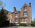
This is a category about listed building number 1201626. |
Grade II listed house in Birkenhead, Wirral, Merseyside, UK  | |||||
| Upload media | |||||
| Instance of | |||||
|---|---|---|---|---|---|
| Location | Wirral, Merseyside, North West England, England | ||||
| Heritage designation |
| ||||
 | |||||
Grade II listed pair of 1840s houses in Birkenhead Park.
Media in category "12 & 14 Ashville Road, Birkenhead"
The following 5 files are in this category, out of 5 total.
-
 12 and 14 Ashville Road, Birkenhead.jpg 4,608 × 3,456; 3.93 MB
-
 12 Ashville Road, Birkenhead.jpg 4,089 × 3,330; 10.17 MB
-
 14 Ashville Road, Birkenhead.jpg 4,014 × 3,135; 9.83 MB
-
 Gate piers of 12 Ashville Road, Birkenhead.jpg 4,527 × 3,381; 12.21 MB
-
 Gate piers of 14 Ashville Road, Birkenhead.jpg 4,498 × 3,374; 12.7 MB


