Category:Östra Karups kyrka
Jump to navigation
Jump to search
| Object location | | View all coordinates using: OpenStreetMap |
|---|
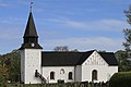
church building in Båstad Municipality, Skåne County, Sweden  | |||||
| Upload media | |||||
| Instance of | |||||
|---|---|---|---|---|---|
| Location | Östra Karup, Båstad Municipality, Skåne County, Sweden | ||||
| Diocese | |||||
| Has use |
| ||||
| Occupant |
| ||||
| Heritage designation |
| ||||
 | |||||
Svenska: Östra Karups kyrka tillhör Båstad-Östra Karups församling, Bjäre kontrakt, Lunds stift / Diocese of Lund, Sverige / Sweden.
|
This is a category about an ecclesiastical monument in Sweden, number 21300000022502 (sub-number: 21400000582601) in the RAÄ buildings database.
|
Subcategories
This category has only the following subcategory.
I
Media in category "Östra Karups kyrka"
The following 34 files are in this category, out of 34 total.
-
 Båstads kommun Östra Karup IMG 5282.jpg 1,369 × 1,038; 618 KB
-
 Östra Karups kyrka - KMB - 16000200035614.jpg 800 × 528; 84 KB
-
 Östra Karups kyrka - KMB - 16000200035616.jpg 800 × 584; 155 KB
-
 Östra Karups kyrka - KMB - 16000200035618.jpg 800 × 500; 61 KB
-
 Östra Karups kyrka - KMB - 16000200035619.jpg 800 × 523; 68 KB
-
 Östra Karups kyrka - KMB - 16000200035621.jpg 379 × 600; 47 KB
-
 Östra Karups kyrka - KMB - 16000200035622.jpg 394 × 600; 44 KB
-
 Östra Karups kyrka - KMB - 16000200035625.jpg 379 × 600; 62 KB
-
 Östra Karups kyrka - KMB - 16000200035626.jpg 380 × 600; 58 KB
-
 Östra Karups kyrka - KMB - 16000200035627.jpg 362 × 600; 50 KB
-
 Östra Karups kyrka - KMB - 16000200035628.jpg 800 × 517; 90 KB
-
 Östra Karups kyrka - KMB - 16000200035631.jpg 800 × 511; 86 KB
-
 Östra Karups kyrka - KMB - 16000200035632.jpg 800 × 526; 104 KB
-
 Östra Karups kyrka - KMB - 16000200035633.jpg 800 × 521; 121 KB
-
 Östra Karups kyrka - KMB - 16000200035634.jpg 800 × 527; 83 KB
-
 Östra Karups kyrka - KMB - 16000200035635.jpg 409 × 600; 27 KB
-
 Östra Karups kyrka - KMB - 16000200035636.jpg 424 × 600; 81 KB
-
 Östra Karups kyrka - KMB - 16000200035637.jpg 471 × 600; 78 KB
-
 Östra Karups kyrka - KMB - 16000200035639.jpg 429 × 600; 71 KB
-
 Östra Karups kyrka - KMB - 16000200035640.jpg 408 × 600; 30 KB
-
 Östra Karups kyrka - KMB - 16000200035642.jpg 600 × 600; 109 KB
-
 Östra Karups kyrka - KMB - 16000200035651.jpg 594 × 600; 97 KB
-
 Östra Karups kyrka 20090413-1.JPG 4,368 × 2,912; 5.33 MB
-
 Östra Karups kyrka 20090413-3.JPG 4,368 × 2,912; 5.11 MB
-
 Östra Karups kyrka 20090413-4.JPG 4,368 × 2,912; 5.36 MB
-
 Östra Karups kyrka 20090413-5.JPG 4,368 × 2,912; 5.44 MB
-
 Östra Karups kyrka 20090413-6.JPG 4,368 × 2,912; 4.63 MB
-
 Östra Karups kyrka maj 2020.jpg 5,306 × 3,537; 3.73 MB
-
 ÖstraKarupsKyrka21500001592659.jpg 2,119 × 1,415; 1.04 MB
-
 ÖstraKarupsKyrka21500001592660.jpg 2,208 × 1,358; 1.06 MB
-
 ÖstraKarupsKyrka21500001592661.jpg 1,844 × 1,625; 940 KB
-
 ÖstraKarupsKyrka21500001592662.jpg 1,772 × 1,692; 1 MB
-
 ÖstraKarupsKyrka21500001592663.jpg 3,872 × 2,592; 3.62 MB
-
 ÖstraKarupsKyrka21500001592668.jpg 3,872 × 2,592; 982 KB


Categories:
- Churches in Båstad Municipality
- 12th-century churches in Båstad Municipality
- Churches in Halland
- Churches in the Diocese of Lund
- Fieldstone churches in Skåne County
- Listed churches in Båstad Municipality
- Saint Olav churches in Sweden
- White churches in Sweden
- Östra Karup
- Romanesque stone churches in Båstad Municipality