Category:Église protestante de Munster
Jump to navigation
Jump to search
| Object location | | View all coordinates using: OpenStreetMap |
|---|
|
This building is indexed in the base Mérimée, a database of architectural heritage maintained by the French Ministry of Culture, under the reference IA68000900
|
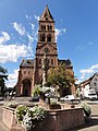
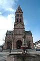
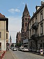
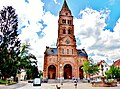
church building located in Haut-Rhin, in France  | |||||
| Upload media | |||||
| Instance of | |||||
|---|---|---|---|---|---|
| Made from material | |||||
| Location | Munster, canton of Munster | ||||
| Street address |
| ||||
| Architect |
| ||||
| Heritage designation | |||||
| Inception |
| ||||
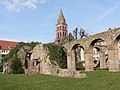
| Significant event |
| ||||
| Religion or worldview | |||||
 | |||||
Media in category "Église protestante de Munster"
The following 28 files are in this category, out of 28 total.
-
 F Grand-Est Munster 3.jpg 2,732 × 2,584; 8.34 MB
-
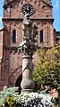
 Fontaine, Munster.jpg 3,264 × 2,448; 1.94 MB
-
 Munster (Haut-Rhin) 2017 DSCN7772 (48676285076).jpg 1,944 × 2,592; 1.1 MB
-
 Munster EgliseProt 02.JPG 2,736 × 3,648; 3.47 MB
-
 Munster EgliseProt 04.JPG 2,736 × 3,648; 3.49 MB
-
 Munster EgliseProt 05.JPG 2,736 × 3,648; 3.35 MB
-
 Munster EgliseProt 06.JPG 2,736 × 3,648; 2.49 MB
-
 Munster EgliseProt 07.JPG 3,648 × 2,695; 2.98 MB
-
 Munster EgliseProt 08.JPG 3,648 × 2,736; 3.57 MB
-
 Munster EgliseProt 10.JPG 3,648 × 2,736; 3.38 MB
-
 Munster plMarché Font (1).JPG 2,056 × 3,648; 2.76 MB
-
 Munster plMarché Font (2).JPG 2,056 × 3,648; 1.86 MB
-
 Munster, dalle funéraire Eccard.jpg 2,848 × 4,272; 2.4 MB
-
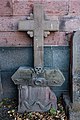 Munster, dalle funéraire Jaeglé.jpg 2,731 × 4,097; 1.81 MB
-
 Munster, dalle funéraire Oesinger.jpg 2,848 × 4,272; 2.21 MB
-
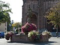
 Munster, fontaine au lion et temple protestant.jpg 2,000 × 3,008; 2.6 MB
-
 Munster, Haut-Rhin 2013-07-09 17.59.25(1) (18038650125).jpg 3,456 × 4,608; 3.99 MB
-
 Munster, Haut-Rhin.jpg 5,760 × 3,840; 7.98 MB
-
-
 Munster, Temple, chœur.jpg 5,184 × 3,456; 8.77 MB
-
 Munster. Le temple. (1).jpg 4,000 × 3,000; 4.05 MB
-
 Munster. Le temple. (2).jpg 3,958 × 2,944; 3.24 MB
-
 Ruines 1.jpg 2,560 × 1,920; 709 KB
-
 Temple de Munster, clocher.jpg 480 × 640; 86 KB
-
 Temple de Munster.JPG 1,836 × 2,483; 928 KB
-
 Temple de Munster.jpg 2,848 × 2,136; 1.44 MB
-
 Temple protestant de Munster (27053484345).jpg 3,000 × 2,000; 3.2 MB
-
 Temple-Munster.jpg 3,840 × 2,160; 8.81 MB


_2017_DSCN7772_(48676285076).jpg)


.JPG)
.JPG)


_(18038650125).jpg)


.jpg)
.jpg)


.jpg)

Categories:
- Buildings in Munster (Haut-Rhin)
- Rue de Sébastopol (Munster)
- Place du Marché (Munster)
- Lutheran churches in Haut-Rhin
- Churches of Église protestante de la Confession d'Augsbourg d'Alsace et de Lorraine
- Romanesque Revival churches in Haut-Rhin
- Churches in Alsace built in 1873
- Churches in Alsace built in 1927
- Friedrich Ludwig von Rütte
- Monuments à l’inventaire in Munster (Haut-Rhin)
- Churches in Arrondissement Colmar-Ribeauvillé