Waratah, New South Wales
Jump to navigation
Jump to search
Waratah is a north-western residential suburb of Newcastle, New South Wales, Australia, located 7 km (4 mi) from Newcastle's central business district and bounded on the north by the Main North line.
-
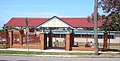
 Waratah Police Station, built in 2002. Located at the Corner of Coolamin and Harriet.
 -
 Waratah Village is the main shopping centre for Waratah.
 -
 Waratah Village is located at the corner of Turton and Georgetown.
 -
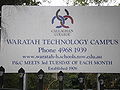 Callaghan College, Waratah Technology Campus.
 -
 The School used to be named Waratah High School, and was once a boy's school
 -
 The School's main entrance is a memorial to those who died in World War II.
 -
 This small apartment block is located on Turton, opposite Waratah High School.
 -
 Waratah was once its own municipality, and this was once the council building. It is now abandoned and badly damaged by fire.
 -
 The rear of the council building, roofless and damaged. The building is located between Waratah Technology Campus and Waratah Oval.
 -
 The founding stone for the council building was laid by Sir Henry Parkes C.C.V.C. on 5th December 1888. It was relaid in 1934.
 -
 Waratah Park is located between Waratah Technology Campus and the Railway Station.
 -
 The Waratah Soldiers' Memorial remembers those who died during World War I.
 -
 A list of Soldiers from Waratah who died in World War I.
 -
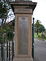
 More names of those who fell during World War I. Waratah Bowling Club can be seen in the background.
 -
 378 men from Waratah enlisted to serve in World War I.
 -
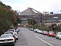
 The Waratah Railway bridge forces traffic to make a 90 degree turn as they travel over it.
 -
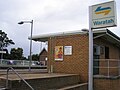 Waratah Railway Station. Station street entrance.
 -
 On the pedestrian bridge at Waratah railway station, looking North-West. Commsteel can be seen a few hundred metres up the track on the right.
 -
 On the pedestrian bridge at Waratah Railway Station, looking South East. The station platforms can be seen in the foreground, with the Road Bridge further back.
 -
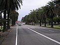 This section of Station Street forms part of the main road leading from Waratah to Mayfield. Palm trees can be seen on either side of the road. Waratah Railway Station can be seen at the end.
 -
 Station Street has a small shopping district, including 2 pubs and a Rugby club.
 -
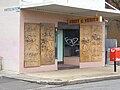 In March 2007, some shops in Station Street had closed down and new businesses had not replaced them.
 -
 The former Waratah Uniting Church is located at the Corner of Station and Dulling. It is now a private residence.
 -
 This is the church's second structure, built in 1955.
 -
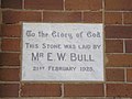
 The church's first structure was built in 1925. It was used as a hall after 1955.
 -
-
 Another founding stone from the 1925 structure.
 -
 Yet another founding stone from the 1925 structure.
 -
 Yet another founding stone from the 1925 structure.
 -
 One of two founding stones from the 1955 structure.
 -
 The second founding stone from the 1955 structure (same date as previous one)
 -
 Many buildings in Waratah were once used for other purposes in the past. Here is an example of a strange, small shed next to a house.
 -
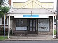 This property, at the corner of Platt and Ada, was once a corner store but is now a private residence. It is also a bus stop, and people waiting for the bus can use the roof for shelter.
 -
 Corpus Christ Primary School is a Catholic School in Platt Street. The Roman Catholic church is located on the other side of the road. It is also called Corpus Christi.
 -
 The Eastern side of Corpus Christi Catholic Church showing the stained glass windows.
 -
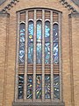 A closeup of the stained glass windows at Corpus Christi Catholic Church.
 -
 Corpus Christi Catholic Church is located at the corner of Platt and Bridge.
 -
 A closer view of Corpus Christi Catholic Church from the Bridge Street side.
 -
 A.M.D.G. Blessed and laid by Most Rev. E. Gleeson C.S.S.R. D.D. Bishop of Maitland May 29th 1932. Rev D. Forde Rector. Rev M. Moylan Assist
 -
 To the north of Corpus Christi is St. Catherine's Nursing Home, at the corner of Bridge and Lorna. The block of land bounded by Bridge Street, Alfred Street, Platt Street and Lorna Street is owned entirely by the Catholic church.
 -
 The Comsteel foundry as seen from the Bridge Street/Lorna Street Roundabout.
 -
 The Mater Misercordiae is the second largest hospital in Newcastle. It is located on Edith Street, Waratah.
 -
 A close-up of the Statue of Mary. The word "Mercy" appears on the emblem underneath.
 -
 The hospital has a functioning emergency department, but mainly focuses upon oncology
 -
 The hospital itself is a "mish-mash" of old and new buildings.
 -
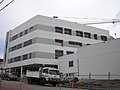 In March 2007, the hospital was undergoing a large building expansion.
 -
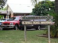 Maroba is a Nursing Home and Retirement village located next to the Mater on Edith Street.
 -
 St Philip's Anglican Church is located on Bridge Street, but can also be accessed on Edith Street.
 -
 The founding stone - 1937
 -
 St. Philip's Christian College was once located on the church grounds. This carpark used to be the playground. The school and the church are now two separate entities.
 -
 St. Philip's Christian College Bridge street entrance, directly across the road from St Philip's Anglican Church.
 -
 Waratah Public School - Lambton Road entrance.
 -
 Television reception has always been difficult in Waratah, which has led to many very tall TV antennas. Since UHF was introduced, reception has improved (the UHF antenna is half-way down the main mast). This house is opposite the Mater.


