Völkermarkt
Jump to navigation
Jump to search
Deutsch: Völkermarkt ist eine Stadt im österreichischem Bundesland Kärnten.
English: Völkermarkt is a city in the Austrian state of Carinthia.
municipality in Völkermarkt District, Carinthia, Austria   | |||||
| Upload media | |||||
| Instance of |
| ||||
|---|---|---|---|---|---|
| Location | Völkermarkt District, Carinthia, Austria | ||||
| Population |
| ||||
| Area |
| ||||
| Elevation above sea level |
| ||||
| official website | |||||
 | |||||
-
 Lage in Kärnten

Admont | Volmat
[edit]Aich | Dobje
[edit]Arlsdorf | Orlača vas
[edit]Dobrowa | Dobrowa
[edit]-
 English:
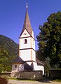
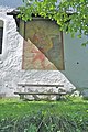
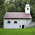
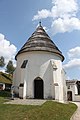
Subsidiary church Saint BartholomewDeutsch:
Filiallkirche Heiliger Bartholomäus

Drauhofen | Dravski Dvor
[edit]Dullach I | Dole pri Šentpetru
[edit]Dullach II | Dole pri Tinjah
[edit]-
 English:
Near #7: Statue of Saint John of NepomukDeutsch:
Nahe Nummer 7: Statue des Heiligen Johannes von Nepomuk am Draubrückenkopf -
 English:
Near #7: Plate text of Saint John of NepomukDeutsch:
Nahe Nummer 7: Tafel zur Statue des Heiligen Johannes von Nepomuk am Draubrückenkopf


Führholz | Borovec
[edit]-
 English:
Tumuli fieldDeutsch:
Hügelgräberfeld -
 English:
Tumuli fieldDeutsch:
Hügelgräberfeld


Gattersdorf | Štriholče
[edit]-
 English:
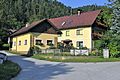
Hamlet San FranzisciDeutsch:
Weiler Sankt Francisci -
 English:
Subsidiary and pilgrimage church San Franzisci XavierDeutsch:
Filial- und Wallfahrtskirche Sankt Franz Xaver -
 English:
Subsidiary and pilgrimage church San Franzisci XavierDeutsch:
Filial- und Wallfahrtskirche Sankt Franz Xaver -
 English:
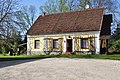
Number 25: RectoryDeutsch:
Nummer 25: Pfarrhof -
 English:
Number 25: RectoryDeutsch:
Nummer 25: Pfarrhof -
 English:
StableDeutsch:
Stallgebäude -
 English:
Wayside chapelDeutsch:
Wegkapelle -
 English:
Number 20: Farmhouse from 1807Deutsch:
Nummer 20: Bauernhaus von 1807 -
 English:
Number 23: FarmhouseDeutsch:
Nummer 23: Bauernhof -
 English:
Number 23: FarmhouseDeutsch:
Nummer 23: Bauernhof


Haimburg | Vovbre
[edit]-
 English:
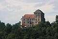
Castle HaimburgDeutsch:
Burg Haimburg -
 English:
Castle HaimburgDeutsch:
Burg Haimburg -
 English:
Castle HaimburgDeutsch:
Burg Haimburg -
 English:
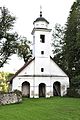
Parish church Assumption DayDeutsch:
Pfarrkirche Unserer Lieben Frau Himmelfahrt


Höhenbergen | Homberk
[edit]-
 English:
Markus Pernhart: CastleDeutsch:
Markus Pernhart: Schloss -
 English:
Castle ruinDeutsch:
Schloss-Ruine -
 English:
Castle ruinDeutsch:
Schloss-Ruine


Klein Sankt Veit | Mali Šentvid
[edit]-
 English:
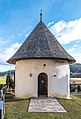
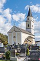
Parish church Saint VeitDeutsch:
Pfarrkirche heiliger Veit -
 English:
Parish church Saint VeitDeutsch:
Pfarrkirche heiliger Veit


Kremschitz | Grunčiče
[edit]-
 English:
View from the Lamprecht´s ballonDeutsch:
Blick vom Lamprechtskogel -
 English:
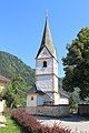
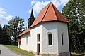
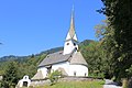
Subsidiary church Saint LeonardDeutsch:
Filialkirche Heiliger Leonhard


Kulm | Hom
[edit]-
 English:
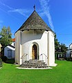
Subsidiary church Saint CatherineDeutsch:
Filialkirche Heilige Katharina -
 English:
Subsidiary church Saint CatherineDeutsch:
Filialkirche Heilige Katharina -
 English:
Painting of Saint Christopher on the east wall of the subsidiary church Saint CatherineDeutsch:
Christophorus-Fresko an der Ost-Wand der Filialkirche Heilige Katharina -
 English:
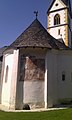
Porch on the south side of the subsidiary church Saint CatherineDeutsch:
Vorlaube an der Südseite der Filialkirche Heilige Katharina -
 English:
Porch on the south side of the subsidiary church Saint CatherineDeutsch:
Vorlaube an der Südseite der Filialkirche Heilige Katharina -
 English:
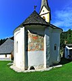
Round apsis on the north side of the subsidiary church Saint CatherineDeutsch:
Rundapsis an der Nordseite der Filialkirche Heilige Katharina


Lassein | Lesine
[edit]Lasseinerbucht
[edit]Lippendorf | Lipovo
[edit]Mittertrixen | Srednje Trušnje
[edit]-
 English:
Castle-ruinDeutsch:
Burgruine -
 English:
CastleDeutsch:
Schloss -
 English:
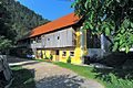
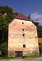
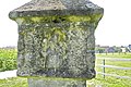
Number 3: Memorial plaque on the late Gothic granaryDeutsch:
Nummer 3: Gedenktafel am spätgotischen Getreidespeicher -
 English:
Number 3: Late Gothic granaryDeutsch:
Nummer 3: Spätgotischer Getreidespeicher -
 English:
Number 3: Late Gothic granaryDeutsch:
Nummer 3: Spätgotischer Getreidespeicher


Neudenstein | Črni Grad
[edit]-
 English:
CastleDeutsch:
Schloss -
 English:
CastleDeutsch:
Schloss -
 English:
CastleDeutsch:
Schloss -
 English:
CastleDeutsch:
Schloss -
 English:
CastleDeutsch:
Schloss -
 English:
CastleDeutsch:
Schloss -
 English:
Subsidiary church Saint UlrichDeutsch:
Filialkirche Heiliger Ulrich -
 English:
Subsidiary church Saint UlrichDeutsch:
Filialkirche Heiliger Ulrich -
 English:
Subsidiary church Saint UlrichDeutsch:
Filialkirche Heiliger Ulrich -
 English:
Subsidiary church Saint UlrichDeutsch:
Filialkirche Heiliger Ulrich


Niedertrixen | Spodnje Trušnje
[edit]Obertrixen | Zgornje Trušnje
[edit]-
 English:
Valvasor: Castle Obertrixen, 1688Deutsch:
Valvasor: Schloss Obertrixen, 1688 -
 English:
Markus Pernhart: Castle Trixen with ruinDeutsch:
Markus Pernhart: Schloss Trixen mit Ruine -
 English:
South portal of the castleDeutsch:
Süd-Portal vom Schloss -
 English:
Castle, 2012Deutsch:
Schloss, 2012 -
 English:
Cartouche of Ludwig Grotta von Grottenegg above the south portal of the castleDeutsch:
Wappenkartusche des Ludwig Grotta von Grottenegg über dem S-Portal vom Schloss -
 English:
Castle chapel, east viewDeutsch:
Schlosskapelle, Ost-Ansicht -
 English:
Castle chapel, 2012Deutsch:
Schlosskapelle, 2012 -
 English:
Gravestone on the castle chapelDeutsch:
Grabstein an der Schlosskapelle


Oschenitzen | Olšenca
[edit]Rakollach
[edit]-
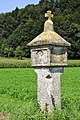
 English:
Burgfried pillar or prelate`s cross of the year 1546, marking the former Burgfried Neudenstein`s boundary point in the open fieldsDeutsch:
Burgfriedsäule oder Prälatenkreuz aus dem Jahr 1546 als Grenzpunkt des ehemaligen Burgfrieds Neudenstein auf freiem Feld -
 English:
Burgfried pillar or prelate`s cross of the year 1546, marking the former Burgfried Neudenstein`s boundary point in the open fieldsDeutsch:
Burgfriedsäule oder Prälatenkreuz aus dem Jahr 1546 als Grenzpunkt des ehemaligen Burgfrieds Neudenstein auf freiem Feld -
 English:
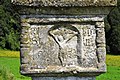
South alcove with the relief “crucifixion” on the Burgfried pillarDeutsch:
Südseitige Nische mit dem Relief „Kreuzigung“ auf der Burgfriedsäule -
 English:
Burgfried pillar or prelate`s cross of the year 1546, marking the former Burgfried Neudenstein`s boundary point in the open fieldsDeutsch:
Burgfriedsäule oder Prälatenkreuz aus dem Jahr 1546 als Grenzpunkt des ehemaligen Burgfrieds Neudenstein auf freiem Feld -
 English:
Burgfried pillar or prelate`s cross of the year 1546, marking the former Burgfried Neudenstein`s boundary point in the open fieldsDeutsch:
Burgfriedsäule oder Prälatenkreuz aus dem Jahr 1546 als Grenzpunkt des ehemaligen Burgfrieds Neudenstein auf freiem Feld -
 English:
North alcove with the relief of a holy bishop on the Burgfried pillarDeutsch:
Nordseitige Nische mit dem Relief eines heiligen Bischofs auf der Burgfriedsäule


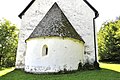
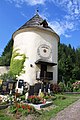
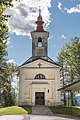
Sankt Agnes | Sveta Neža, Šentaneža
[edit]-
 English:
Subsidiary church Saint AgnesDeutsch:
Filialkirche Heilige Agnes -
 English:
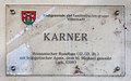
Charnel houseDeutsch:
Karner -
 English:
Charnel houseDeutsch:
Karner
.JPG)

.JPG)
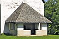
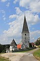
Sankt Georgen am Weinberg | Šentjur na Strmcu
[edit]Parish church Saint George | Pfarrkirche hl. Georg
[edit]-
 English:
View from the Lamprecht`s ballonDeutsch:
Blick vom Lamprechtskogel -
 English:
Southern viewDeutsch:
Süd-Ansicht -
 English:
Southern viewDeutsch:
Süd-Ansicht -
 English:
Northeastern viewDeutsch:
NO-Ansicht -
 English:
Northeastern viewDeutsch:
NO-Ansicht -
 English:
Western viewDeutsch:
West-Ansicht -
 English:
Open air altar at the porchDeutsch:
Opfertisch in der offenen Vorhalle -
 English:
Tampanum, west portalDeutsch:
Tympanon, W-Portal -
 English:
Door at the Anne's chapelDeutsch:
Tür zur Annenkapelle -
 English:
Stoup at the Anne's chapelDeutsch:
Weihwasserbecken am Eingang der Annenkapelle -
 English:
Stoup at the Anne's chapelDeutsch:
Weihwasserbecken am Eingang der Annenkapelle -
 English:
Polygonal apseDeutsch:
Chorpolygon -
 English:
Ogival arched light alcove at the east side of the apseDeutsch:
Kielbogige Lichtnische im Osten des Chorpolygons


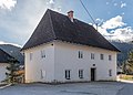
Rectory | Pfarrhof
[edit]-
 English:
Northeastern viewDeutsch:
NO-Ansicht

Schloss Frankenstein, Rahmschüsselhof
[edit]-
 English:
Southern viewDeutsch:
Süd-Ansicht

Sankt Jakob | Šentjakob
[edit]-
 English:
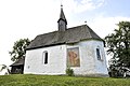
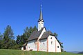
Subsidiary church Saint JacobDeutsch:
Filialkirche Heiliger Jakob
.JPG)
Sankt Lorenzen | Šentlovrenc
[edit]-
 English:
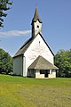
Subsidiary church Saint LawrenceDeutsch:
Filialkirche heiliger Laurentius
.JPG)
Sankt Margarethen ob Töllerberg | Šmarjeta pri Velikovcu
[edit]Parish church Saint Margaret | Pfarrkirche hl. Margaretha
[edit]-
 English:
Southeastern viewDeutsch:
SO-Ansicht -
 English:
Southwestern viewDeutsch:
SW-Ansicht -
 English:
Southwestern viewDeutsch:
SW-Ansicht -
 English:
Southwestern viewDeutsch:
SW-Ansicht -
 English:
Eastnortheastern viewDeutsch:
ONO-Ansicht -
 English:
Eastnortheastern viewDeutsch:
ONO-Ansicht -

Porch}Deutsch:
Turmvorhalle -
 English:
Gothic apseDeutsch:
Gotischer Chorschluss -
 English:
Gothic tracery windowDeutsch:
Gotisches Maßwerkfenster -
 English:
Porch with portal and epitaphDeutsch:
Vorhalle mit W-Portal und Epitaph -
 English:
Gothic western portal at the porchDeutsch:
Gotisches W-Portal in der Vorhalle -
 English:
Epitaph for Felix Victor Rauber zu Reinegg und Obertrixen at the porchDeutsch:
Epitaph für Felix Victor Rauber zu Reinegg und Obertrixen in der Vorhalle -
 English:
Tympanum of the Gothic western portal at the porchDeutsch:
Tympanon vom gotischen W-Portal in der Vorhalle -
 English:
Painting of Saint Christopher at the south wallDeutsch:
Fresko des hl. Christophorus an der S-Wand


Cemetery with romanesque charnel house | Friedhof mit romanischem Rundkarner
[edit]-
 English:
Western viewDeutsch:
West-Ansicht -
 English:
Western viewDeutsch:
West-Ansicht -
 English:
Western viewDeutsch:
West-Ansicht -
 English:
Western viewDeutsch:
West-Ansicht -
 English:
Eastern viewDeutsch:
Ost-Ansicht -
 English:
Romanesque windowDeutsch:
Romanisches Fenster -
 English:
Wayside shrine at the cemetery wallDeutsch:
Bildstock in der Friedhofsmauer -
 English:
Painting of Saint Margaret in the alcove of the wayside shrine at the cemetery wallDeutsch:
Malerei der hl. Margaretha in der Bildstocknische in der Friedhofsmauer


War memorial | Kriegerdenkmal
[edit]-
 English:
War memorialDeutsch:
Kriegerdenkmal

Sankt Martin | Šmartin
[edit]-
 English:
Subsidiary church Saint MartinDeutsch:
Filialkirche Heiliger Martin
.JPG)
Sankt Peter am Wallersberg | Šentpeter na Vašinjah
[edit]-
 English:
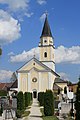
Parish church Saint PeterDeutsch:
Pfarrkirche Sankt Peter

Sankt Stefan | Šentštefan
[edit]-
 English:
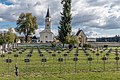
Parish church Saint Stephen with cemeteryDeutsch:
Pfarrkirche Heiliger Stefan mit Friedhof -
 English:
Parish church Saint StephenDeutsch:
Pfarrkirche Heiliger Stefan -
 English:
Charnel houseDeutsch:
Karner -
 English:
Charnel houseDeutsch:
Karner -
 English:
Charnel houseDeutsch:
Karner -
 English:
Charnel houseDeutsch:
Karner -
 English:
Charnel houseDeutsch:
Karner -
 English:
Painting "Last Judgment" on the charnel houseDeutsch:
Fresko „Jüngstes Gericht“ am Karner -
 English:
RectoryDeutsch:
Pfarrhof -
 English:
RectoryDeutsch:
Pfarrhof -
 English:
RectoryDeutsch:
Pfarrhof -
 English:
Alcove wayside shrineDeutsch:
Laubenbildstock


.jpg)


Tainach | Tinje
[edit]Priory building | Propsteihof
[edit]-
 English:
Complex with collegiate churchDeutsch:
Komplex mit Pfarrkirche -
 English:
Eastern viewDeutsch:
Ost-Ansicht -
 English:
Northern viewDeutsch:
Nord-Ansicht -
 English:
Northern viewDeutsch:
Nord-Ansicht -
 English:
Northern portalDeutsch:
Nord-Portal -
 English:
Northern portalDeutsch:
Nord-Portal


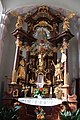
Collegiate church Assumption Day and Saint Valentin | Propsteikirche Mariä Himmelfahrt und heiliger Valentin
[edit]-
 English:
Northeastern viewDeutsch:
NO-Ansicht -
 English:
Northern viewDeutsch:
Nord-Ansicht -
 English:
Western viewDeutsch:
West-Ansicht -
 English:
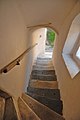
Steeple`s staircaseDeutsch:
Treppenaufgang zum Turm -
 English:
Steeple`s staircaseDeutsch:
Treppenaufgang zum Turm -
 English:
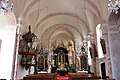
InteriorDeutsch:
Innenansicht -
 English:
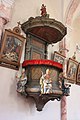
PulpitDeutsch:
Kanzel -
 English:
Main altarDeutsch:
Hauptaltar -
 English:
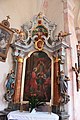
Valentine`s altarDeutsch:
Valentinsaltar -
 English:
Altar "Last Supper"Deutsch:
Letztes Abendmahl-Altar -
 English:
Barbara altarDeutsch:
Barbara Altar -
 English:
Adoration of the MagiDeutsch:
Anbetung der Könige -
 English:
FrescoDeutsch:
Fresko -
 English:
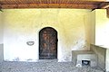
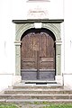
PortalDeutsch:
Portal -
 English:
Eastern metal doorDeutsch:
Östliche Eisentür


Fortified cemetery | Wehrkirchhof
[edit]-
 English:
Grave chapel for the provostsDeutsch:
Grabkapelle für die Pröpste -
 English:
Cemetery wall with round tower in the northDeutsch:
Friedhofsmauer mit Rundturm im Norden -
 English:
Gothic round towerDeutsch:
Gotischer Rundturm


Tainacherfeld | Tinjsko Polje
[edit]-
 English:
Alcove wayside shrineDeutsch:
Nischenbildstock

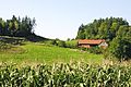
Töllerberg | Telenberk
[edit]-
 English:
CastleDeutsch:
Schloss -
 English:
CorncobsDeutsch:
Maikolben


Unterlinden | Podlipa
[edit]#9: Castle Thalenstein | Nr. 9: Schloss Thalenstein
[edit]-
 English:
Southern viewDeutsch:
Süd-Ansicht -
 English:
Southern viewDeutsch:
Süd-Ansicht


Völkermarkt | Velikovec
[edit]Augustinerweg
[edit]-
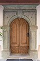
 English: Number 2: Lutheran Christ churchDeutsch: Nummer 2: Evangelische Christuskirche
 -
 English: Number 2: Lutheran Christ churchDeutsch: Nummer 2: Evangelische Christuskirche
 -
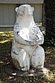 English: Sculpture “Sitting Bear”Deutsch: Figur „Sitzender Bär“


Bäckergasse
[edit]-
 English: Alley connecting 2. Mai-Strasse and KirchgasseDeutsch: Verbindungsgasse zwischen 2. Mai-Straße und Kirchgasse

Bürgerlustgasse
[edit]-
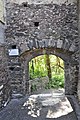 English: Number 8: Third dity gate in the old town wallDeutsch: Nummer 8: Drittes Stadttor in der alten Stadtmauer

Griffner Strasse
[edit]-
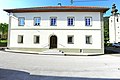
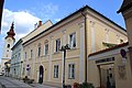
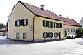 English: Number 4: Old middle-class houseDeutsch: Nummer 2: Altes Bürgerhaus
 -
 English: Road bridge across the MuehlgrabenDeutsch: Straßenbrücke über den Mühlgraben


Hauptplatz
[edit]-
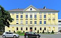
 English: Number 1: Town hallDeutsch: Nr. 1: Alter Herzoghof - Rathaus
 -
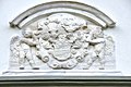
 English: DreifaltigkeitssäuleDeutsch: Trinity Column
 -
 English: Number 6: Gallery MagnetDeutsch: Nr. 6: Galerie Magnet
 -
 English: Number 22: Former municipal hallDeutsch: Nr. 22: Altes Rathaus
 -
 English: Number 22: Former municipal hallDeutsch: Nr. 22: Altes Rathaus
 -
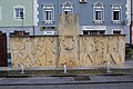 English: War memorialDeutsch: Kriegerdenkmal


Kirchgasse
[edit]-
 English:
Number 6: New provost houseDeutsch:
Nummer 6: Neue Propstei -
 English:
Number 6: New provost houseDeutsch:
Nummer 6: Neue Propstei -
 English:
Number 6: New provost houseDeutsch:
Nummer 6: Neue Propstei -
 English:
Number 6: New provasty, portalDeutsch:
Nummer 6: Neue Propstei, Portal -
 English:
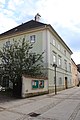
Number 8: New deaneryDeutsch:
Nummer 8: Neue Dechantei -
 English:
Number 8: New deaneryDeutsch:
Nummer 8: Neue Dechantei -
 Kapitelmesnerhaus
 -
 Kapitelmesnerhaus
 -
 English:
Number 26: Relic of the old city fortification, the "Griffner Tor"Deutsch:
Nummer 26: Erhaltenes Stadtmauerstück, Teil vom „Griffner Tor“


Gothic light column | Gotische Lichtsäule
[edit]-
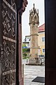 English:
Northeastern viewDeutsch:
Nordost-Ansicht -
 English:
Northern viewDeutsch:
Nord-Ansicht -
 English:
Northern viewDeutsch:
Nord-Ansicht -
 English:
Northern viewDeutsch:
Nord-Ansicht -
 English:
Southeastern viewDeutsch:
Südost-Ansicht -
 English:
 InscriptionDeutsch: Inschrift


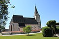
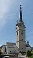
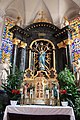
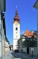
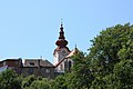
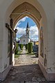
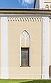
Parish church Saint Mary Magdalene | Pfarrkirche heilige Maria Magdalena
[edit]-
 English:
Western viewDeutsch:
West-Ansicht -
 English:
Western viewDeutsch:
West-Ansicht -
 English:
Western viewDeutsch:
West-Ansicht -
 English:
Western viewDeutsch:
West-Ansicht -
 English:
Eastern viewDeutsch:
Ost-Ansicht -
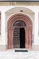 English:
Western portalDeutsch:
West-Portal -
 English:
Western portalDeutsch:
West-Portal -
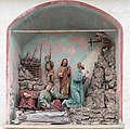 English:
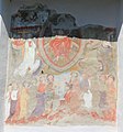
Jesus Christ on the Mount of OlivesDeutsch:
Jesus am Ölberg -
 Christus am Ölberg
 -
 Kreuzigungsgruppe
 -
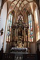
 English:
NaveDeutsch:
Mittelschiff -
 English:
Main altarDeutsch:
Hauptaltar -
 Rosenkranz-Altar
 -
 Vierzehn-Nothelfer-Altar
 -
 Herz Jesu-Altar
 -
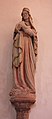 English:
MadonnaDeutsch:
Madonna -
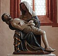 Pieta
Pieta -
 Schmerzensmann
 -
 Aus dem Marienleben
 -
 Schutzmantelmadonna
 -
 Tod Mariens


Klagenfurter Straße
[edit]-
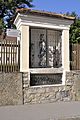
 English:
Wayside chapel “14 helpers in need”Deutsch:
14-Nothelfer-Kapelle -
 English:
Number 15: Former citizen hospital with hospital chapelDeutsch:
Nummer 15: Ehemaliges Bürgerspital mit Bürgerspitalskapelle -
 English:
Number 20: Police district headquarterDeutsch:
Nummer 20: Bezirkspolizeikommando -
 English:
Wayside chapel “Rosalia”Deutsch:
Rosalienkapelle


Mettingerstraße
[edit]-
 English:
Number 16: Old middle-class schoolDeutsch:
Nummer 16: Alte Bürgerschule -
 English:
Number 16: Old middle-class schoolDeutsch:
Nummer 16: Alte Bürgerschule


Postriegelstraße
[edit]-
 English:
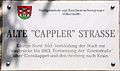
Plaque for the old “Cappler” RoadDeutsch:
Beschreibung der alten „Cappler“ Straße -
 English:
Former “Cappler” RoadDeutsch:
Alte „Cappler Straße“


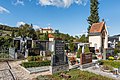
Sankt Ruprecht
[edit]Parish church Saint Rupert and cemetery | Pfarrkirche hl. Ruprecht und Friedhof
[edit]-
 English:
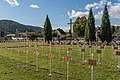
World War II cemetery Saint RupertDeutsch:
Heldenfriedhof des II. Weltkriegs in Sankt Ruprecht -
 English:
Western viewDeutsch:
West-Ansicht -
 English:
Westsouthwestern viewDeutsch:
WSW-Ansicht -
 English:
Westsouthwestern viewDeutsch:
WSW-Ansicht -
 English:
Westsouthwestern viewDeutsch:
WSW-Ansicht -
 English:
Westsouthwestern viewDeutsch:
WSW-Ansicht -
 English:
Westsouthwestern viewDeutsch:
WSW-Ansicht -
 English:
Western wallDeutsch:
West-Wand -
 English:
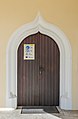
Western portalDeutsch:
West-Portal -
 English:
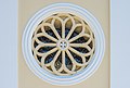
Rose windowDeutsch:
Rosetten-Fenster -
 English:
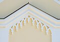
PedimentDeutsch:
Ziergiebel -
 English:
PlaqueDeutsch:
Info-Tafel -
 English:
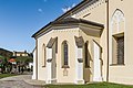
Porch and side chapelDeutsch:
Vorlaube und Seitenkapelle -
 English:
South portalDeutsch:
Südportal -
 English:
Side chapelDeutsch:
Seitenkapelle -
 English:
Side chapelDeutsch:
Seitenkapelle -
 English:
Gothic tracery window at the side chapelDeutsch:
Gotisches Maßwerkfenster an der Seitenkapelle -
 English:
Gravestone of Georg Orrieschnigg at the side chapelDeutsch:
Grabstein von Georg Orrieschnigg an der Seitenkapelle -
 English:
Barred windowDeutsch:
Gitterfenster -
 English:
Base of the belltowerDeutsch:
Basis des Glockenturms -
 English:
West part of the cemeteryDeutsch:
West-Teil vom Friedhof -
 English:
Cemetery chapel “Crucifixion”Deutsch:
Friedhofskapelle „Kreuzigung“ -
 English:
Cemetery chapel “Crucifixion”Deutsch:
Friedhofskapelle „Kreuzigung“ -
 English:
Gravstones of family MösslacherDeutsch:
Grabsteine der Familie Mösslacher -
 English:
Grave of family JaritzDeutsch:
Grabstätte der Familie Jaritz -
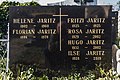 English:
Gravestone of family JaritzDeutsch:
Grabstein der Familie Jaritz -
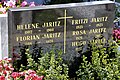 English:
Gravestone of family JaritzDeutsch:
Grabstein der Familie Jaritz


.JPG)


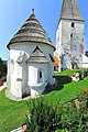
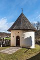
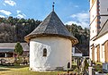
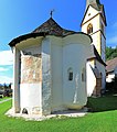
Ossuary with Saint Michael’s chapel | Karner mit Sankt Michaelskapelle
[edit]-
 English:
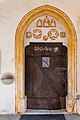
PlaqueDeutsch:
Info-Tafel -
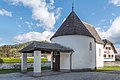 English:
Southwestern viewDeutsch:
SW-Ansicht -
 English:
Southeastern viewDeutsch:
SO-Ansicht -
 English:
Southeastern viewDeutsch:
SO-Ansicht


Spanheimergasse
[edit]-
 English:
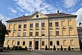
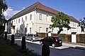
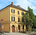
Number 2: District authorityDeutsch:
Nummer 2: Bezirkshauptmannschaft -
 English:
Number 2: Inner yard of the district authorityDeutsch:
Nummer 2: Innenhof der Bezirkshauptmannschaft -
 English:
Number 2: Plaque in the entrance hall of the district authorityDeutsch:
Nummer 2: Inschrifttafel im Eingangs-Flur der Bezirkshauptmannschaft -
 English:
Number 2: Memorial plaque for abbot Paul in the entrance hall of the district authorityDeutsch:
Nummer 2: Gedenkstein für Abt Paul im Eingangs-Flur der Bezirkshauptmannschaft


Stadtfriedhof und Friedhofskapelle
[edit]-
 English:
Cemetery chapel, northern viewDeutsch:
Friedhofskapelle, Nord-Ansicht -
 English:
Cemetery chapel, northeastern viewDeutsch:
Friedhofskapelle, NO-Ansicht -
 English:
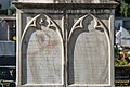
Mortuary, southeastern viewDeutsch:
Aufbahrungshalle, SO-Ansicht -
 English:
ReliefDeutsch:
Relief -
 English:
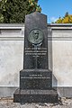
Gravestone of Dr. med. August KrassniggDeutsch:
Grabstein von Dr. med. August Krassnigg


2. Mai Strasse
[edit]-
 English:
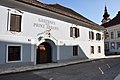
2.-Mai-Strasse: Prinzhofer houseDeutsch:
2.-Mai-Straße: Prinzhofer Haus

Weinbergstraße
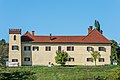
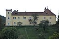
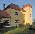
[edit]#2: Castle Kohlhof | Nr. 2: Schloss Kohlhof
[edit]-
 English:
Eastern viewDeutsch:
Ost-Ansicht -
 English:
Eastern viewDeutsch:
Ost-Ansicht -
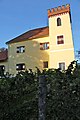 English:
# 2: Castle Kohlhof, battlementDeutsch:
Nr. 2: Schloss Kohlhof, Zinnenturm -
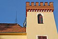 English:
# 2: Castle Kohlhof, battlementDeutsch:
Nr. 2: Schloss Kohlhof, Zinnenturm -
 English:
# 2: Castle Kohlhof, battlementDeutsch:
Nr. 2: Schloss Kohlhof, Zinnenturm -
 English:
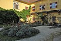
# 2: Castle KohlhofDeutsch:
Nr. 2: Schloss Kohlhof -
 English:
# 2: Castle Kohlhof, inner yardDeutsch:
Nr. 2: Schloss Kohlhof, Innenhof -
 English:
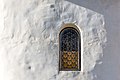
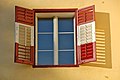
# 2: Castle Kohlhof, windowDeutsch:
Nr. 2: Schloss Kohlhof, Fenster -
 English:
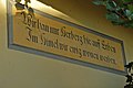
# 2: Castle Kohlhof, inscriptionDeutsch:
Nr. 2: Schloss Kohlhof, Inschrift -
 English:
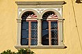
# 2: Castle Kohlhof, mullioned Renaissance windowDeutsch:
Nr. 2: Schloss Kohlhof, gekuppeltes Renaissancefenster -
 English:
# 2: Side building of castle KohlhofDeutsch:
Nr. 2: Nebengebäude von Schloss Kohlhof


Miscellaneous | Diverses
[edit]-
 Brunnen
 -
 Stadtmuseum
 -
 Bezirksgericht
 -
Evangelische Kirche
-
Alte Bürgerschule
-
Pfarrkirche St.Ruprecht
-
Karner in St Ruprecht
-
 Stadtturm Grabplatte Sonnegg
 -
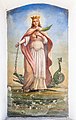
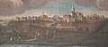 Völkermarkt auf einem Votivbild in der Pfarrkirche
 -
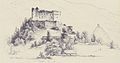
 Markus Pernhart: Völkermarkt


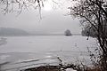
Völkermarkter Stausee
[edit]-
 English:
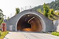
Lilienbergtunnel, southeast portalDeutsch:
Lilienbergtunnel, SO-Portal -
 English:
Northeastern viewDeutsch:
NO-Ansicht -
 English:
Western viewDeutsch:
West-Ansicht -
 English:
Road signs along the B82 roadDeutsch:
Verkehrszeichen an der B82-Straße -
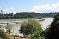
 English:
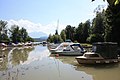
Boat harbor Neudenstein on the barrier lakeDeutsch:
Bootshafen Neudenstein am Stausee -
 English:
Boat harbor Völkermarkt on the barrier lakeDeutsch:
Bootshafen Völkermarkt am Stausee -
 English:
Boat harbor Völkermarkt on the barrier lakeDeutsch:
Bootshafen Völkermarkt am Stausee -
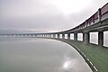
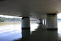
 English:
Bridge across the barrier lake of the river DravaDeutsch:
Brücke über den Stausee der Drau -
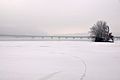 English:
Bridge across the barrier lake of the river DravaDeutsch:
Brücke über den Stausee der Drau -
 English:
Bridge across the barrier lake of the river DravaDeutsch:
Brücke über den Stausee der Drau -
 English:
Bridge across the barrier lake of the river DravaDeutsch:
Brücke über den Stausee der Drau -
 English:
Bridge across the barrier lake of the river DravaDeutsch:
Brücke über den Stausee der Drau -
 English:
Bridge across the barrier lake of the river DravaDeutsch:
Brücke über den Stausee der Drau -
 English:
Bridge across the barrier lake of the river DravaDeutsch:
Brücke über den Stausee der Drau -
 English:
Bridge across the barrier lake of the river DravaDeutsch:
Brücke über den Stausee der Drau -
 English:
Bridge across the barrier lake of the river DravaDeutsch:
Brücke über den Stausee der Drau -
 English:
Bridge across the barrier lake of the river DravaDeutsch:
Brücke über den Stausee der Drau -
 English:
Bridge across the barrier lake of the river DravaDeutsch:
Brücke über den Stausee der Drau -
 English:
Restaurant on the barrier lake of the Drava riverDeutsch:
Restaurant am Stausee der Drau -
 English:
MV MagdalenaDeutsch:
MS Magdalena


Waisenberg | Važenberk
[edit]Cast-iron wayside cross from the year 1862 | Gusseisernes Kreuz von 1862
[edit]-
 English:
Cast-iron wayside cross from the year 1862Deutsch:
Gusseisernes Kreuz von 1862 -
 English:
Inscripiton at the base of the cast-iron wayside cross from the year 1862Deutsch:
Inschrift an der Basis des gusseisernen Kreuzes von 1862


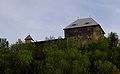
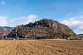
Castle ruin Waisenberg | Burgruine Waisenberg
[edit]-
 English:
Southwestern viewDeutsch:
SW-Ansicht -
 English:
Southwestern viewDeutsch:
SW-Ansicht


Lamprechtskogel
[edit]-
 English:
Western viewDeutsch:
West-Ansicht -
 English:
Southwestern viewDeutsch:
SW-Ansicht -
 English:
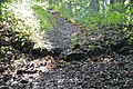
Hallstatt culture site of a former hill-top settlement, situated on top of the Lamprecht`s ballonDeutsch:
Fundstätte einer ehemaligen Hallstattkultur Siedlung auf dem Lamprechtskogel -
 English:
Hallstatt culture site of a former hill-top settlement, situated on top of the Lamprecht`s ballonDeutsch:
Fundstätte einer ehemaligen Hallstattkultur Siedlung auf dem Lamprechtskogel -
 English:
Subsidiary church Saints Lambertus and Marcus on the Lamprecht ballonDeutsch:
Filialkirche Heilige Lambertus und Markus am Lamprechtskogel -
 English:
Waisenberg Kremschitz LamprechtskogelDeutsch:
Waisenberg Kremschitz Lamprechtskogel


Miscellaneous | Diverses
[edit]-
English:
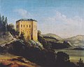
Castle FrankensteinDeutsch:
Schloss Frankenstein -
 English:
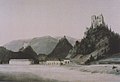
Markus Pernhart: Castle ruin WaisenbergDeutsch:
Markus Pernhart: Burgruine Waisenberg

Wandelitzen | Vodovnica
[edit]-
 English:
Subsidiary church Saint MichaelDeutsch:
Filialkirche Heiliger Michael

Views
[edit]-
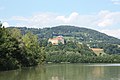
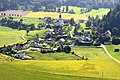
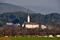
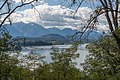
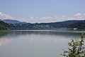
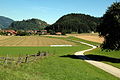
 View over Wasserhofen (Žirovnica), a village of the community of Eberndorf, towards the river Drau, city of Völkermarkt in the background

