User:Zde/Corinth
Archaeological sites of Corinth
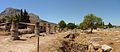
General views
[edit]With the exception of the Temple of Apollo, almost all visible objects date from Roman and early Byzantine times.
-
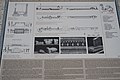
 Map
Map -
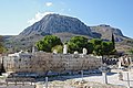
 Temple of Apollo and Acrocorinth
 -

-

-
 Ancient Corint from the Acrocorint


Main Archaeological site
[edit]In the Ancient Corinth. In order according to the progress of the trip, although at the cost of turns.
-
 Plan
Plan -
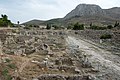
 Main Archaeological area from the Acrocorint


Near the Entrance
[edit]| Object location | | View all coordinates using: OpenStreetMap |
|---|
Coordinates of the Entrance
-
 Entrance
 -

-
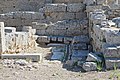
 Fountain of Glauke
 -
 Fountain of Glauke and the Museum
 -
 To the Museum
 -
 From Museum to the West shops


Fountain of Glauke
[edit]| Object location | | View all coordinates using: OpenStreetMap |
|---|


Details
[edit].jpg)


Archaeological Museum
[edit]See Archaeological Museum of Ancient Corinth
Temple of Octavia
[edit]| Object location | | View all coordinates using: OpenStreetMap |
|---|

.jpg)
.jpg)
_(2).jpg)


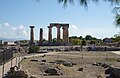
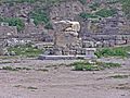
Temple of Apollo
[edit]Around 560-540 BC, Doric order, on the site of the temple of the 7th century BC.
-
-
 Painted terracotta in the Museum
 -
-
 1762
1762 -
 1829
1829 -
 1829
1829 -
 1843
1843 -
 1843
1843 -
 1910
1910 -
 1923
1923


SW corner
[edit]| Object location | | View all coordinates using: OpenStreetMap |
|---|
.jpg)


West pediment
[edit](But this was the back of the temple.)


.jpg)


North site
[edit]
_(2508884337).jpg)


_(Gr%C3%A8cia).jpg)


East side
[edit]From the Archaic period, access to the hilltop was up a monumental staircase at the southeast corner of the hill (see North Building).


Sourth site
[edit].jpg)


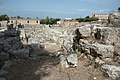
Surroundings of former Agora
[edit]South and southeast of the Apollon temple
.jpg)


West shops
[edit]| Object location | | View all coordinates using: OpenStreetMap |
|---|
.jpg)


West Terrace Temples
[edit]
Northwest Stoa
[edit]

.jpg)

Northwest Shops
[edit]| Object location | | View all coordinates using: OpenStreetMap |
|---|


Sacred spring
[edit]| Object location | | View all coordinates using: OpenStreetMap |
|---|


.jpg)


Bema
[edit]| Object location | | View all coordinates using: OpenStreetMap |
|---|
-

-

-
-

-

-

-

-

-

-
 6th century Christian Basilica
 -

-
-


_(4700440195).jpg)


Julian Basilica
[edit]| Object location | | View all coordinates using: OpenStreetMap |
|---|
Secular Basilica. See also Sculptures from the Julian Basilica in the Arachaeological Museum of Corinth.
-
 From Bema
 -

-
-


.jpg)

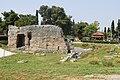
Fountain of Peirene
[edit]| Object location | | View all coordinates using: OpenStreetMap |
|---|


.jpg)


.jpg)


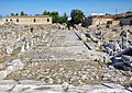
Lechaion Road and surroundings
[edit]East of the Apollon temple
Propylaia
[edit]| Object location | | View all coordinates using: OpenStreetMap |
|---|
Between Lechaion and Agora, near Peirene Fontain


.jpg)

Peribolos of Apollo
[edit]| Object location | | View all coordinates using: OpenStreetMap |
|---|


North Building
[edit]| Object location | | View all coordinates using: OpenStreetMap |
|---|
-

-

-

-

-

-

-
 Above the North Building


.jpg)


.jpg)

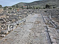
Lechaion Road
[edit]-
-
-

-

-

-
-
 View back toward the Propylaea
 -
-

-
-

-

-
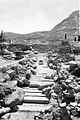 1898
1898


.jpg)


Other
[edit]-
 Heroon
 -
 Bouleterion
 -
 South Stoa
 -

-

-
-
-
 Byzantine Church near Peirene Fountain
 -

-


.jpg)

Ancient Greek Theatre
[edit]Near the Main Archaeological site


Roman Odeon
[edit]Near the Main Archaeological site


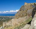
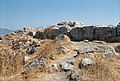
Acrocorinth
[edit]Modern entrance
[edit]


Ancient entrance
[edit].jpg)
.jpg)
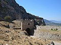
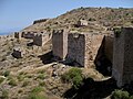
Gates and fortresses
[edit]-

-

-
-
-

-

-

-

-
-

-
 Venetian Tower
 -


.jpg)


.jpg)


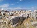
Temple of Aphrodite
[edit]| Object location | | View all coordinates using: OpenStreetMap |
|---|
See Strabo, Geography VIII,6,20 and XII,4,36.
See Pausanias, Description of Greece II,4 and II,5,1.
-
-

-
-

-

-
 View from the Temple of Aphrodite


Upper Peirene
[edit]Upper Peirene Fountain


