User:Rolandc73/gallery
Jump to navigation
Jump to search
Sat Oct 21 22:39:19 CDT 2006
[edit]errors
[edit]- Image:Branson-satellite-map.jpg UnexpectedAnswerException unexpected response data (SimpleAction) status HTTP/1.0 200 OK
-
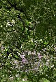
Satellite image of Albuquerque, New Mexico
-
Satellite image of Alexandria, Louisiana
-
Satellite image of Au Sable, Michigan
-
 Satellite image of Awaji Island Japan
 -
Satellite image of Bakersfield, California
-
 Satellite image of Bangor, Maine
 -
Satellite image of Baton Rouge, Louisiana
-
 Satellite image of Beaumont, Texas
 -
Satellite image of Beaver Island in Michigan
-
Photo of the island of Hawaii from the Space Shuttle.
-
 Satellite image of Billings, Montana
 -
 This poster of the Mississippi Gulf Coast from Biloxi, Mississippi, to the edge of Mobile, Alabama, includes LANDSAT 7 satellite images of pre-hurricane and post-hurricane views. The bottom image, acquired on September 8, 2005, in comparison to the same area in 2004 (top image), reveals how the brunt force of the hurricane not only affected the coastline, but also reached the inland areas of the Pascagoula River.
 -
 Satellite image of Birmingham, Alabama
 -
Satellite image of Boulder and Longmont, Colorado
-
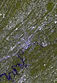
Satellite image of Branson, Missouri
-
Satellite image of Breckenridge, Colorado
-
Satellite image of Bridgeport, Connecticut
-
Satellite image of Caballo Lake State Park in New Mexico
-
Satellite image of Cape Charles, Virginia
-
Satellite image of Cape Cod Bay
-
Satellite image of Cape Girardeau, Missouri
-
Satellite image of Carson City, Nevada
-
 Satellite image of Carters Lake in Georgia
 -
Satellite image of Charlotte, North Carolina
-
Satellite image of Chattanooga, Tennessee
-
Chequamegon Bay in Wisconsin
-
Satellite image of Cherokee Lake in Tennessee
-
This heavy snowstorm in January 2005 left the city digging out for days. This scene captures Chicago drapped in white with strong winds whipping out over the lakefront.
-
 A beautiful afternoon in October 2001 is captured here in this 3 ft wide by 2 ft satellite wall poster covering the Choctawhatchee Bay, Destin, and Niceville, Florida region.
 -
This LANDSAT scene from July of 2000 shows the Cody Wyoming area along with Buffalo Bill State Park. Cody is located at the western edge of the Big Horn Basin, a depression surrounded by the Big Horn, Wind River, and Absoroka ranges. At the western edge of Cody, a deep canyon formed by the north fork of the Shoshone River provides the only passage to Yellowstone's Eastern Entrance. At its mouth and rising above Cody are Rattlesnake Mtn. on the north side, and Cedar Mountain on the south side.
-
Home of the Fighting Texas Aggies! This ASTER satellite scene captures these Texas twin cities on a cloudless day in December 2001.
-
The image above is a visualization created by merging natural-color imagery (Bands 3, 2, and 1) from the Landsat 7 satelliteÕs Enhanced Thematic Mapper Plus (ETM+) instrument collected on September 20, 2002, with elevation data from the Shuttle Radar Topography Mission (SRTM) that flew on the Space Shuttle Endeavor, which launched in February 2000.
-
Beautifully detailed ASTER satellite scene over the Colorado Springs area.
-
 Satellite Image of Cozumel. Cozumel is an island in the Caribbean Sea off the eastern coast of Mexico's Yucat‡n Peninsula, opposite Playa del Carmen. It is one of the eight municipalities (municipios) of the state of Quintana Roo. Cozumel is a popular tourist destination renowned for its scuba diving. The main town on the island is San Miguel.
 -
Digital photo of Crater Lake taken from teh International Space Station. According to the U.S. Geological Survey, Crater Lake is the deepest lake in the United States, with an average depth of 350 meters (1,148 feet). Water is lost only by evaporation and seepage, and is only replenished by rainwater and snowmelt from the surrounding crater walls.
-
Aster satellite poster of Crater Lake from April 2006.
-
Beautifully detailed ASTER satellite scene over the sprawling Denver area.
-
Aster satellite image of Detroit, Michigan from July 2006.
-
ASTER satellite image of Dubai City. The city of Dubai is located in the northeastern part of the United Arab Emirates (UAE) along the Persian Gulf. The upper part of the image shows the center of the city, which developed along the west side of the Dubai Creek. Off the coast of Jumeirah Beach is the world's largest man-made island resort The Palm in the Persian Gulf, now under construction.
-
A gorgeous Hawaiian day in February 2001 is shown in this ASTER satellite image of the eastern shore of Oahu.
-
Satellite image of Elephant Butte Reservoir. Created by a dam constructed in 1916 across the Rio Grande, iit's 40 miles long with more than 200 miles of shoreline. Although constructed to provide for irrigation and flood control, the lake is New Mexico's premier water recreation facility.
-
 Satellite image of Fall River, Massachusetts
 -
 Satellite image of Flagstaff, Arizona
 -
Satellite image of Flathead Lake in Montana
-
 Satellite image of Frederickburg, Virginia
 -
 Satellite image of Fresno, California
 -
Satellite image of Fort Lauderdale, Florida
-
 Satellite image of Galveston, Texas
 -
Satellite image of Glacier National Park
-
Satellite image of the Grand Canyon in Arizona
-
Satellite image of Green Bay, Wisconsin
-
Satellite image of Guadalupe Mountains National Park
-
Satellite image of the island of Guam
-
 Satellite image of Hampton, Virginia
 -
Satellite image of Hartwell Lake in Georgia
-
Satellite image of the Hawaiian Islands
-
 Satellite image of Homer, Alaska
 -
 Satellite image of Huntsville, Alabama
 -
 Satellite image of Jackson, Mississippi
 -
 LANDSAT satellite image of Jacksonville, Florida
 -
 Satellite image of Juneau, Alaska
 -
Satellite image of Kalgin Island in Alaska
-
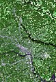
Satellite image of Kansas City
-
Satellite image of Kennedy Space Center
-
Satellite image of Key West and Boca Chica Key
-
Satellite image of Keystone Lake in Oklahoma
-
 Satellite image of Knoxville, Tennessee
 -
Satellite image of the island of Kohoolawe
-
Satellite image of Lake Berryessa in California
-
Satellite image of Lake Eufaula in Oklahoma
-
Satellite image of Lake Oconee in Georgia
-
Satellite image of Lake of the Ozarks in Missouri
-
Satellite image of Lake Placid, New York
-
Satellite image of Lake Sinclair in Georgia
-
Satellite image of Lake Winnebago in Wisconsin
-
Satellite image of Lake Tahoe
-
 Satellite image of Lake Anna, Virginia
 -
 Satellite image of Lake Kenai in Alaska
 -
Satellite image of the island of Lanai
-
Satellite image of Las Cruces, New Mexico
-
 Satellite image of Las Vegas, Nevada
 -
Satellite image of Little Rock, Arkansas
-
Satellite image of London, England
-
Satellite image of Los Angeles, California
-
 Satellite image of Lubbock, Texas
 -
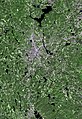
Satellite image of Madison, Wisconsin
-
 Satellite image of Manassas, Virginia
 -
Satellite image of Manila in the Philippines
-
Satellite image of Mark Twain Lake in Missouri
-
Satellite image of Milwaukee, Wisconsin
-
 Satellite image of Missoula, Montana
 -
 Satellite image of Mito, Japan
 -
Satellite image of Modesto, California
-
Satellite image of Mono Lake in California
-
 Satellite image of Montgomery, Alabama
 -
 Satellite image of Mount Rainier in Washington
 -
Satellite image of Mount Rainier in Washington
-
Satellite image of Muskegon, Michigan
-
Satellite image of Nashville, Tennessee
-
Satellite image of New York, New York
-
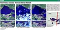 This poster shows LANDSAT satellite images of New Orleans, Louisiana, as floodwaters from Hurricane Katrina begin to recede. The image on the far left was acquired by LANDSAT 7 on August 30, 2005, one day after Katrina made landfall. The middle image was acquired by LANDSAT 5 on September 7, 2005, one week after the hurricane hit, and the image on the far right was acquired by LANDSAT 7 on September 15, 2005, two weeks after the hurricane devastated the region.
 -
 Satellite image of Nome, Alaska
 -
 Satellite image of Norris Lake in Tennessee
 -
Satellite image of the north shore of Oahu
-
 Satellite image of Ogden, Utah
 -
Satellite image of Lake Okeechobee in Florida
-
Satellite image of Oklahoma City, Oklahoma
-
Satellite image of Olympia, Washington
-
Satellite image of Olympic National Park
-
Satellite image of Oogolah Lake in Oklahoma
-
 This poster shows an image subset over New Orleans, Louisiana, acquired on September 6, 2005, by the Advanced Land Imager (ALI) sensor on Earth Observing-1 (EO-1). The lower map shows the extent of the floodwaters after the levee breach. The full ALI image is shown along the left edge.
 -
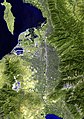
 Satellite image of Osaka, Japan
 -
Satellite image of Oyster Bay, New York
-
 Satellite image of Padre Island National Seashore
 -
Satellite image of Pearl Harbor, Hawaii
-
Satellite image of Port Jefferson, New York
-
 Satellite image of Pueblo, Colorado
 -
Satellite image of Reno, Nevada
-
 Satellite image of Reston, Virginia
 -
Satellite image of Richmond, California
-
 Satellite image of Richmond, Virginia
 -
Satellite image of Rocky Mountain National Park
-
Satellite image of Ruidoso, New Mexico
-
Satellite image of the islands of Saipan and Tinian in the Northern Marianas
-
 Satellite image of Salt Lake City, Utah
 -
Satellite image of Sam Rayburn Reservoir in Texas
-
Satellite image of San Antonio, Texas
-
Satellite image of the San Bernardino National Forest
-
Satellite image of San Francisco Bay
-
Satellite image of Santa Clarita, California
-
Satellite image of the Santa Cruz Mountains in California
-
Satellite image of Santa Fe, New Mexico
-
Satellite image of the Santa Monica Mountains National Recreation Area
-
Satellite image of Seattle and Tacoma, Washington
-
Satellite image of Seoul, South Korea
-
 Satellite image of Seward, Alaska
 -
Satellite image of Singapore
-
Satellite image of Sleeping Bear Dunes National Lakeshore
-
Satellite image of Springfield, Missouri
-
Satellite image of Stockton Lake in Missouri
-
Satellite image of Taipei, Taiwan
-
Satellite image of Taitung, Taiwan
-
 Satellite image of Texarkana, Texas
 -
Satellite image of the Bahamas
-
Satellite image of Topeka, Kansas
-
Satellite image of Tulsa, Oklahoma
-
 Satellite image of Tuscaloosa, Alabama
 -
 Satellite image of Utah Lake and Provo, Utah
 -
Satellite image of Ventura, California
-
Satellite image of Wake Island
-
Satellite image of Washington Island, Wisconsin
-
Satellite image of Waukegon, Illinois
-
Satellite image of the Whiskeytown, Shasta, and Trinity National Recreation Areas in California
-
 Satellite image of Worcester, Massachusetts
 -
 The image shows the urbanization of the world's cities through the use of the DMSP satellite system. This image of Earth's city lights was created with data from the Defense Meteorological Satellite Program (DMSP) Operational Linescan System (OLS). Originally designed to view clouds by moonlight, the OLS is also used to map the locations of permanent lights on the Earth's surface. The brightest areas of the Earth are the most urbanized, but not necessarily the most populated. (Compare western Europe with China and India.) Cities tend to grow along coastlines and transportation networks. The United States interstate highway system appears as a lattice connecting the brighter dots of city centers. In Russia, the Trans-Siberian railroad is a thin line stretching from Moscow through the center of Asia to Vladivostok. The Nile River, from the Aswan Dam to the Mediterranean Sea, is another bright thread through an otherwise dark region. Even more than 100 years after the invention of the electric light, some regions remain thinly populated and unlit. Antarctica is entirely dark. The interior jungles of Africa and South America are mostly dark, but lights are beginning to appear there. Deserts in Africa, Arabia, Australia, Mongolia, and the United States are poorly lit as well (except along the coast), along with the boreal forests of Canada and Russia, and the great mountains of the Himalaya. Data courtesy Marc Imhoff of NASA GSFC and Christopher Elvidge of NOAA NGDC. Image by Craig Mayhew and Robert Simmon, NASA GSFC.
 -
 Satellite image of Wupatki National Monument in Arizona
 -
Satellite image of the island of Yap
-
 Satellite image of Yavapai County, Arizona
 -
Satellite image of Yuma, Arizona
-
Satellite image of Yushan National Park in Taiwan
-
Satellite image of Acadia National Park in Maine
-
 Satellite image of Anchorage, Alaska
 -
Satellite image of Annapolis, Maryland
-
Satellite image of Aspen, Colorado
-
Satellite image of the Auckland Islands
-
 Satellite image of Augustine Island Volcano
 -
 Satellite image of Austin, Texas
 -
Satellite image of Baltimore, Maryland
-
Satellite image of Bangor, Maine
-
Satellite image of Big Horn Canyon National Recreation Area
-
 Satellite image of Biscayne National Park
 -
Satellite image of the Black Canyon of the Gunnison National Recreation Area
-
 Photo of the Black Hills of South Dakota from the Space Shuttle
 -
Satellite image of Bloomington, Illinois
-
 Satellite image of Boothbay Harbor in Maine
 -
 Satellite image of Boston, Massachusetts
 -
 Satellite image of Brownsville, Texas
 -
 Satellite image of Buzzards Bay
 -
Satellite image of Cabo San Lucas in Mexico
-
 Satellite image of Cancun
 -
 Satellite image of Canyon de Chelly National Monument
 -
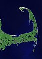 Satellite image of Cape Cod
 -
 Satellite image of Cape May in New Jersey
 -
Satellite image of Lake Allatoona in Georgia
-
Satellite image of Champaign, Illinois
-
 Satellite image of the Channel Islands National Park
 -
 Satellite image of Charleston, South Carolina
 -
Satellite image of Chicago, Illinois
-
Satellite image of Chiricahua Mountains in Arizona
-
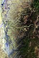
 Satellite image of the south coast of France


