User:Jsayre64/Photos
Jump to navigation
Jump to search
Not much organization here.
Links in captions point to articles in which the photos appear.
All licenses are CC-BY-SA unless otherwise noted in parentheses.

-

-
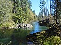
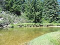
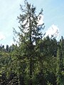
 The same species at Brice Creek east of Cottage Grove
 -
-
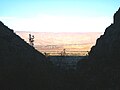
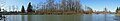
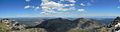
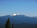
 Diamond Peak in the Cascade Range in Oregon, seen from the northeast, with Mount Yoran at far right
 -
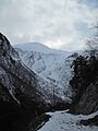
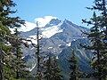
 View from Diamond Peak in spring
 -
 View east from the southern side of Diamond Peak, with Crescent Lake in the distance
 -
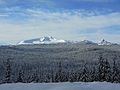
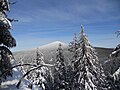
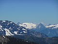
 Summit Lake and Cowhorn Mountain (at left) seen from the Diamond Peak Wilderness
 -
 The ridge to the summit of Diamond Peak, on the western side of the mountain
 -
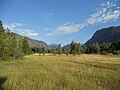
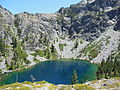
 A shallow, marshy lake beside a trail in the Diamond Peak Wilderness
 -
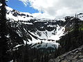
 Marie Lake in the wilderness just south of Diamond Peak
 -
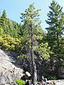
 Noble fir (Abies procera) at Notch Lake in the Diamond Peak Wilderness
 -
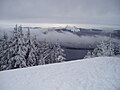
 View north from the summit of Diamond Peak, with Willamette Pass Resort and Odell Lake (right) faintly visible through smoky skies
 -
 View south from the summit
 -
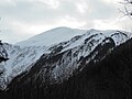
 The false summit on the western side of Diamond Peak as seen from the south
 -
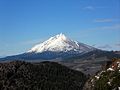
 Diamond Peak as seen from Willamette Pass (PD)
 -
 Odell Lake from Willamette Pass Resort
 -
 Gold Lake with Salt Creek flowing out of it, just west of Willamette Pass
 -
 Diamond Peak as seen across Upper Marilyn Lake, also west of Willamette Pass
 -
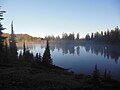
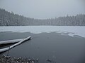 Midnight Lake in the Diamond Peak Wilderness
 -
-
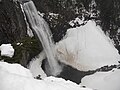
 Salt Creek Falls
 -
 Salt Creek in its canyon below Salt Creek Falls
 -

-
 Diamond Peak from the North Fork Trail
 -
-
 Panorama of frozen Upper Marilyn Lake
 -
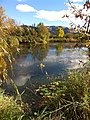
 Upper Marilyn Lake
 -

-
 A panorama of some of the view from Maiden Peak
 -
 Revised version of the panorama—see description page
 -
 The north slope of Maiden Peak, with three lakes in the background
 -
 The end of the Maiden Peak Trail at the summit of Maiden Peak
 -
 A cairn at the summit of Maiden Peak
 -
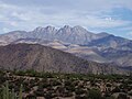
 Maiden Peak seen from Willamette Pass Resort
 -
 Davis Lake from Maiden Peak
 -
 Diamond Peak, Mount Yoran, and Willamette Pass Resort from Maiden Peak
 -
 Maiden Peak seen from Mount Ray, looking southeast
 -

-
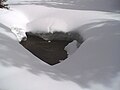 A hole in snow, shaped as a heart, in the Oregon Cascades near Willamette Pass
 -
 An accidentally Oregon-shaped pizza (PD)
 -
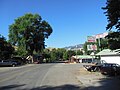
 17th Street in Pacific Grove, California, as it runs toward Monterey Bay
 -
-
-
 View northeast across Agua Fria National Monument in Yavapai County, Arizona, USA. Numerous side canyons feed into the Agua Fria River canyon. Interstate 17 is in the bottom-left of this frame.
 -
-

-
 A more unusual sunset from the summer before
 -
 The stick of a dead tree or bush in shallow water in the eastern Great South Bay
 -

-

-
-
 Aerial view northwest over Lincoln County, Nebraska, USA. The plane is over Wellfleet, Nebraska, looking toward Sutherland Reservoir and the Interstate 80 corridor, which here follows the North Platte and South Platte rivers as they converge.
 -
 Aerial view of the Platte River and the Interstate 80 corridor at Gothenburg, Nebraska, USA
 -
 Aerial view of Hamilton, Ontario, in winter, looking northwest. Hamilton Harbour is frozen over, but immediately east of it, Lake Ontario is not. The dark curved line to the south and east of the city center is the Niagara Escarpment.
 -
 Aerial view, looking south, of the St. Clair River, which delineates the Michigan–Ontario border, and the river's mouth on Lake St. Clair
 -
 Aerial view, looking south, of the northern suburbs of Chicago along Lake Michigan, with the city's skyscrapers in the distance
 -
 Aerial view of the Blue Ridge Mountains in western North Carolina
 -
 Aerial view of Fontana Lake in the Great Smoky Mountains of North Carolina
 -

-

-

-

-
 Fall Creek
 -
 A shaded pool of Fall Creek
 -

-
 Dexter Reservoir and the city of Lowell
 -
-

-

-
 The sunset's effect on Mount Pisgah
 -
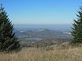
 View southeast from the summit of Mount Pisgah, with snow-capped Diamond Peak faintly visible in the distance at the center of the frame
 -
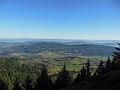
 View north from Pisgah as smog and fog sit in the Willamette Valley
 -
 View northwest from Pisgah, again showing the layer of smog
 -
 View west-southwest from Mount Pisgah, showing Spencer Butte
 -
 Part of the southern side of Mount Pisgah through rain
 -
 Wetlands near Mount Pisgah
 -
 A field of short grass west of Mount Pisgah
 -
 A mushroom of the Entoloma genus at Mount Pisgah
 -
 A channel of the Coast Fork Willamette River below Mount Pisgah (PD)
 -
 The Coast Fork Willamette in the same area
 -
 A faster current on the Coast Fork
 -
 Panorama of the Coast Fork
 -

-

-
 The Willamette River flowing through Eugene
 -
 The high and muddy Willamette River on a rainy day at Champoeg State Park
 -
 Two American robins (Turdus migratorius) in a tree covered in glaze ice after freezing rain in Eugene
 -

-
 Grasses at Fern Ridge Reservoir
 -
 A Sunday afternoon baseball game between the Seattle Mariners and the Chicago White Sox in Seattle in 2015
 -

-
 Franklin Gutiérrez batting for the Mariners against the White Sox
 -
 Adam LaRoche at first base for the White Sox
 -
 Avisaíl García batting for the White Sox
 -
 Mark Trumbo playing first base for the Mariners
 -
 Robinson Canó batting for the Mariners
 -

-

-

-

-

-

-
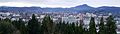 Downtown Eugene skyline and Spencer Butte as seen from Skinner Butte
 -
 Downtown Eugene skyline (before crop)
 -

-
 The view south from the butte
 -
 The looming sunset in the west as the butte is sandwiched between cloud layers
 -
 View southwest from Spencer Butte
 -
 The view east, with peaks of the Cascades in the distance
 -
 The Coburg Hills in Lane County poking through fog, seen from Spencer Butte
 -
 Fog east of Spencer Butte stretching to the Cascades
 -
 Communications towers in Eugene poking through fog covering the Willamette Valley
 -
 The top edge of a fog layer on Spencer Butte
 -
 Fog above a trail on Spencer Butte
 -
 Lookout Point Reservoir as seen from Route 58 in Lane County
 -
 A small section of the reservoir that is south of the highway
 -
 A large mushroom on the forest floor near Hardesty Mountain in Lane County
 -
 A coral mushroom species belonging to the Ramaria genus, near Hardesty Mountain
 -
 Two specimens of the same mushroom species near Hardesty Mountain
 -

-

-

-

-

-

-

-

-
 View from the south jetty at the mouth of the Siuslaw River towards the north one
 -
 Same thing, looking up the mouth of the Siuslaw
 -
 View down the south jetty, with the Pacific beach on the left and the Siuslaw's mouth at right
 -
 View down the mouth
 -
 A hotel beside Glenada Road in the unincorporated community of Glenada on the coast
 -
 Siltcoos Lake at Dunes City, just inland from the coast
 -

-
 The dam on the Siltcoos River
 -
 The Siltcoos under a July morning sky
 -
 The banks and clear water of the river
 -
 A calm stretch of the river with warm water
 -
 A slow bend of the Siltcoos, a perfect place for swimming
 -
 The river where it has spread out on the sand, curving toward the ocean
 -
 The Siltcoos still inching onward to the Pacific
 -
 The South Santiam River at Trout Creek Campground in Linn County, Oregon
 -

-
-
 Radio or weather equipment fenced in on the summit of Marys Peak in the Coast Range in Benton County (PD)
 -

-
 Seeley Creek, a tributary of the North Fork Alsea, at Clemens Park
 -
 Vegetation in the Coast Range near Route 126
 -
 Pacific trillium (Trillium ovatum) with a pink hue on the petals, in the same area
 -
 Twoflower violet (Viola biflora)
 -
 Salmonberry (Rubus spectabilis)
 -
 Western skunk cabbage (Lysichiton americanus)
 -
-
-
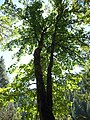
 California incense cedar (Calocedrus decurrens) tree near the McKenzie
 -
 Douglas-fir (Pseudotsuga menziesii) tree in front of Douglas fir forest by the McKenzie
 -
 The McKenzie River at Nimrod
 -
 Cascade Locks, a windy city in the Columbia River Gorge in Hood River County, Oregon
 -
 Cascade Locks
 -

-
-

-
-

-

-
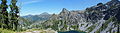
 Ann Lake below Maple Pass in the North Cascades
 -
 Panoramic view of Ann Lake and the U-shaped valley of its outlet
 -

-
 Panorama of views northwest to northeast from the summit of Tiffany Mountain
 -
 Panorama of views east to southeast from Tiffany Mountain
 -
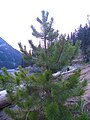
 Whitebark pine (Pinus albicaulis) at Tiffany Mountain
 -
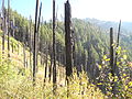
 Trees burned by wildfire just south of Tiffany Mountain
 -
-

-
 Silver Star Mountain in the North Cascades, looking south from Slate Pass
 -

-
 View downstream on Icicle Creek
 -
 Black cottonwood across Icicle Creek
 -

-
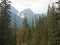
 Lodgepole pine in the Alpine Lakes Wilderness in the Cascade Range in Washington
 -
 A burnt lodgepole pine in the Alpine Lakes Wilderness
 -
 Little Eightmile Lake in the wilderness
 -
 Eightmile Lake, upstream from Little Eightmile Lake, in the wilderness
 -
 Burn area in the wilderness
 -
 Another burn section
 -
 The trail from Eightmile Lake
 -
 Mixed conifers in the wilderness
 -
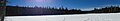
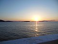 The sun setting over the San Juan Islands in Washington
 -
 Mushrooms on the tundra in Yukon, Canada, on the eastern edge of Kluane National Park
 -
 Dall sheep (Ovis dalli) in mountains above the Donjek valley in northern Kluane National Park
 -

-

-
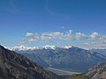 View west across the Donjek valley toward the largest mountains of Yukon
 -
 Panorama of the lower northern slopes of Mount Hoge in northern Kluane National Park
 -
 Aerial view southeast up the upper Fraser River valley in the Rocky Mountains of British Columbia
 -
 South-pointing aerial view of a fjord of Baffin Island, south of Adams Island, Nunavut, Canada
 -
 View south over northern Baffin Island, Nunavut, Canada. The view looks across the island of Qikiqtaaluk (formerly Sillem Island) in Baffin Bay, including its rocky northern peninsula (foreground).
 -
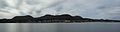
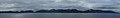
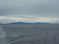
 Calvert Island on the British Columbia coast from a ferry boat in the Inside Passage
 -
 A peak on Calvert Island
 -
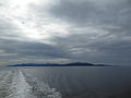
 The island from the northeast, showing the ferry's wake
 -

-
 Panorama of Bella Bella
 -
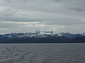
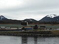
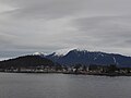 The city of Wrangell, Alaska, from an approaching ferry boat
 -
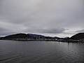
 Wrangell from the ferry
 -
 Wrangell from the ferry again
 -
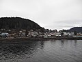
 Wrangell and its ferry terminal
 -
 Wrangell and its ferry terminal again
 -

-
 Slight crop of the panorama
 -
 Part of the peninsula
 -
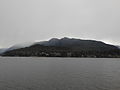 Mountain Point, Alaska, a community near Ketchikan with a population of 372
 -

-
 Panorama of part of Ketchikan, Alaska, from a ferry boat
 -
 View down Hoadley Creek in Ketchikan
 -
 View up the creek
 -
 Alaska Marine Lines cargo in Ketchikan (PD)
 -
 Ketchikan International Airport from a docked ferry
 -
-
 Gravina Island, where Ketchikan's airport is, from the north
 -
 Mendenhall Lake in front of the Mendenhall Glacier, in the Juneau borough, as rain falls
 -
 The Mendenhall Glacier from a trail beside Mendenhall Lake
 -
 A plane flying over the Gastineau Channel in front of the Mendenhall Glacier
 -

-

-
 Gold Creek from another bridge
 -
 Gold Creek from the Perseverance Trail
 -
 Gastineau Peak above downtown Juneau from the Perseverance Trail
 -
 Gastineau Peak
 -
 The Alaska Fishermen's Building near the State Capitol in Juneau (PD)
 -
 Temple Sukkat Shalom in Juneau (PD)
 -
 Side view of the Wickersham House in Juneau
 -
 The front of the Wickersham House
 -
 Mountains behind Juneau as seen across the Gastineau Channel from Douglas Island
 -
 Panorama of the mainland from Douglas Island
 -
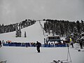
 A two-frame panorama of the West Bowl at Eaglecrest Ski Area on Douglas Island
 -
 An area of untracked snow at Eaglecrest
 -
 A steep, groomed run at Eaglecrest
 -

-
 Panorama of the view from Douglas Island
 -

-
 Oregon's John Day River as seen from a nearby hill
 -
 The John Day as seen from an island in the middle of the river
 -
 View of the John Day canyon upstream of Clarno from a slope on the left bank, in Wasco County, looking downstream and across to Wheeler County
 -
 Panorama from 27 stitched frames of the John Day between the communities of Service Creek and Twickenham, showing nearly all 360 degrees of the view, with the river flowing to the right
 -
 Eroded rock formation above the John Day River near Clarno
 -
 Sign for the Clarno Recreation Site across the John Day River from Clarno, Oregon (PD)
 -
-
 Covered picnic tables at the Clarno Unit of John Day Fossil Beds National Monument, in Wheeler County
 -
 Big sagebrush (Artemisia tridentata) in the John Day canyon
 -
 Leaves and berries of the Western Juniper (Juniperus occidentalis), also in the canyon
 -
 Close-up of juniper foliage and berries
 -
 A tree snag in a grassy meadow beside the river
 -
 Bird nests on the side of the North Twickenham Road bridge over the John Day River at Twickenham, an unincorporated community
 -
 The John Day and the Twickenham bridge
 -
 A slow-moving section of the river near the community of Service Creek
 -
 Horses beside the river between Service Creek and Twickenham, in Wheeler County
 -
 A rainbow trout (Oncorhynchus mykiss) in the river, near Service Creek
 -
 Remains of a rainbow trout in the sand along the river
 -
 A collection of animal bones, likely those of cattle, found dispersed along the river
 -
 A long gopher snake (Pituophis catenifer) on a bank above the river
 -
 A garter snake in some brush beside a gravel road in the Coast Range in Douglas County, Oregon
 -

-
 A train passing by Westfir on the Union Pacific Railroad
 -

-
 The North Fork Middle Fork
 -
 The river again, looking upstream
 -
 The river seen from the trail
 -
-
 Douglas firs on timberland in Douglas County
 -
 Pacific madrone (Arbutus menziesii) on a sunny hillside near the Callahans climbing area
 -
 Pasture below the Callahans
 -
-
-
-
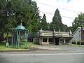
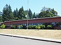
 Another part of the school building in Goshen (PD)
 -
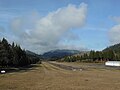
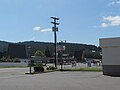
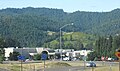
 Goshen from Interstate 5
 -

-
-

-
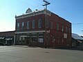
 Sutherlin, one of the larger cities in Douglas County
 -
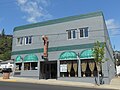
 A store in Oakland, a city in Douglas County (PD)
 -

-

-
 The Burnside Bridge, a bascule bridge over the Willamette River in downtown Portland
 -

-
 Ice over Big Lake, in front of (from left) Mount Washington, North Sister, and Middle Sister
 -
 The same general scene, but with Hayrick Butte in the bottom left
 -
 This time with a slope of Hoodoo ski area in the bottom right
 -
 View north to Mount Washington from an area between it and North Sister
 -
 Mount Washington as seen from the Old Cascades to the west
 -
 Snow in the B&B Complex burn scar near Santiam Pass, nearly 11 years after the fires
 -
 The view east to the Three Sisters from Benson Lake in the Three Sisters Wilderness
 -
 View from the Three Sisters Wilderness to Mount Washington, Three Fingered Jack, Mount Jefferson, and Mount Hood
 -

-

-
 The Deschutes River from a bridge on Route 126 just north of Cline Falls State Scenic Viewpoint and a few miles west of Redmond
 -

-
 Three Fingered Jack as seen from the southwest on a nearby trail in the Mount Jefferson Wilderness
 -
 Three Fingered Jack as seen from the Old Cascades to the west
 -
-
 Mount Jefferson as seen from the Old Cascades to the southwest
 -

-
 Mount Jefferson from Jefferson Park, an area of meadows north of the mountain, with early morning light hitting the snow and ice
 -
 Mount Jefferson under the clear morning sky
 -
 Mount Jefferson in the morning
 -

-
-
 A creek cutting through the Whitewater Trail
 -
 A rocky slope above the Whitewater Trail
 -
 Bays Lake in Jefferson Park
 -
 Most of Bays Lake
 -
 Fog over Scout Lake in Jefferson Park
 -
 Lingering fog over Scout Lake in front of Park Butte before sunrise
 -
 Scout Lake in the early morning
 -
 Sun rays through thin fog in Jefferson Park
 -
 Sunlight hitting the fog low to the ground
 -
 A meadow in Jefferson Park
 -
 Jefferson Park from the north side of Mount Jefferson
 -
 Mount Hood from the north side of Mount Jefferson
 -
 Phantom Ship, a small island near the southern shore of Crater Lake
 -

-
 A panorama of the Iowa River at a park in Coralville, Iowa, in Johnson County
 -
 Different version of the panorama
 -
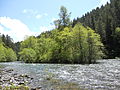
 The North Umpqua River near Steamboat, Oregon
 -
 A broader view of the same section of the North Umpqua
 -

-
 The trail in the Boulder Creek Wilderness
 -
 Burnt trees in the wilderness
 -
-
 Forest below Mount June
 -
 Larger trees below Mount June
 -
 View up to the canopy in the forest
 -
 Aerial view north from the eastern edge of Yosemite National Park, California
 -
 Aerial view northeast of the Spring Mountains in southwest Nevada
 -
-
 Panoramic view from northwest to east of the Siskiyous, seen from the same spot
 -
 The north side of Bear Mountain in the Siskiyou Wilderness
 -
 Bear Mountain an hour later
 -
 Devils Punchbowl below Bear Mountain, looking down from the west
 -
 Western white pine (center) and Douglas-fir (right) in front of mixed conifer forest in the Siskiyou Wilderness
 -
 Weeping spruce (Picea breweriana) above the northwest shore of Devils Punchbowl
 -
 A part of the small lake below Devils Punchbowl, with Douglas fir along the shore
 -
 A ridge with talus/scree of large rock fragments northwest of Devils Punchbowl
 -
 View north of the conifer forest of the Siskiyou Mountains in California, with Oregon in the distance, seen from outside the northern part of the Siskiyou Wilderness
 -
 Western white pine in the Siskiyou Wilderness
 -

-

-
 The U.S. post office at McCloud (PD)
 -

-
 The Douglas Chair at Mount Shasta Ski Park
 -
 The base of the ski area
 -
 The West Face ski run and the Douglas Chair


.JPG)


.jpg)


.JPG)


.JPG)


.JPG)


.JPG)


.jpg)


.JPG)


_and_Baffin_Island,_Canada,_March_2023.jpg)


.JPG)


_from_the_west.jpg)


_from_the_southwest.jpg)


.JPG)

,_thin_fog.JPG)


