User:Jmabel/Seattle street photography by Guy Scott circa 1917-1920
University of Washington Library Special Collections has an enormous collection of old Seattle photographs, most of which have been digitized (some at high resolution, most only in the range of about 0.5 megapixels). Of these, User:BMacZero has uploaded thousands that are in the public domain, and I (Joe Mabel, on Commons as User:Jmabel) have been categorizing these and adding further descriptions; much of what I've worked out has fed back to the UW Library's own database and site. The prior level of curation of these photos on the UW Library site varies: in general, I've been able either to add significant information or correct outright errors (dates, locations, even subject matter) on about 20% of the thousands of images I've now studied.
.jpg)
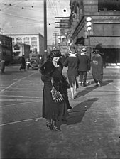
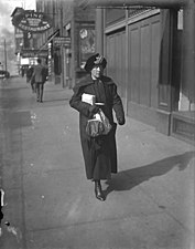
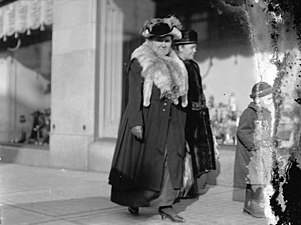
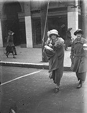
Among the items in the collection are about 150 photos taken by Guy Scott in Downtown Seattle and on the waterfront circa 1917-1920. This doesn't count his many images of parades, etc.: this is straight-out "street photography." Most of these had minimal metadata on the UW Library site: that they were taken by Guy Scott in that timeframe, and a description along the lines of "women crossing a street in Downtown Seattle." I've been going through these and for most I've been able to pin down the location (or, in some cases, correct an incorrect location). For a few, I could even narrow the date. I've also, in some cases, identified interesting subject matter beyond just people walking down a street, and for a handful I've been able to show that they are flopped left-right.
This page (currently work in progress) is an attempt to sum up what I've found. I will be passing all of this back to my contact at the UW Library, and I hope much of what I've worked out makes it on to their site as well.
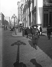
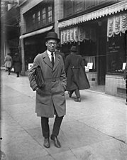
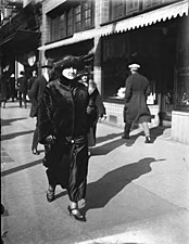
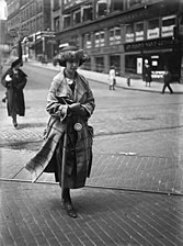
Going through these I noticed a few things, some of which were helpful in working out locations of the photos. (1) Guy Scott had a good eye. There pictures here add up to a very interesting portrait of the people of a particular American city at a particular date. A few people obviously were not thrilled he was taking their picture but, hey, that's one of the characteristics of this sort of street photography. (2) Scott was not an early riser, or if he was then he had something else to do with his mornings. As a result, to keep the light at his back, his camera is typically aimed north or east. (3) He liked to pick a spot and do a lot of shooting from the one location, and he shot with a pretty wide aperture. These photos don't end up producing as much of a picture of the physical structure of the city as they do of the people. There are relatively large numbers of photos of a relatively few locations, because he clearly found those good places to shoot; his rather wide aperture meant that often signs behind the people are not in focus and cannot easily be read. Nonetheless, in the following, I'm classifying them in terms of location, because that's my expertise. Someone else could probably have a nice go at these in terms of the fashions of the era.
Known locations
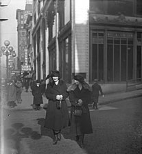
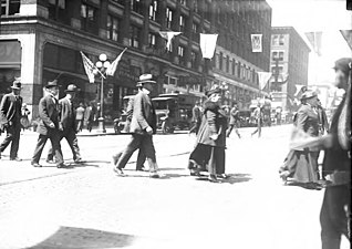
[edit]Among the largest groups in those terms was shot on the west side of Second Avenue, looking north at the crosswalk at Union Street, toward what was then the block-long Bon Marché department store occupying several buildings on Second Avenue. Some of these were misidentified on the UW Library's site as being at Second and Pine (the other end of the store) but that would entail the camera pointing west. Enough of these show enough background (e.g. the New Washington Hotel, now Josephinum, at Second and Stewart) that we can absolutely say these are at Union looking north, and if you look at the tram tracks (and, in particular a few paving bricks that were at odd angles due to the tram tracks) it is pretty much a foregone conclusion that the others are all in the same spot.
Here and below, I'm providing the UW Libraries source URLs for the photos to help their librarian be able to use this information efficiently.
.jpg)
.jpg)
.jpg)
.jpg)
.jpg)
.jpg)
.jpg)
.jpg)
.jpg)
.jpg)
.jpg)
.jpg)
.jpg)
.jpg)
.jpg)
.jpg)
.jpg)
.jpg)
.jpg)
.jpg)
.jpg)
.jpg)
.jpg)
.jpg)
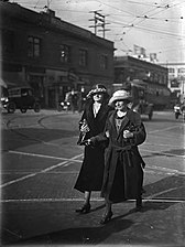
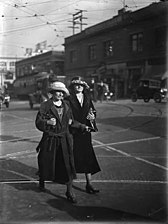
There are also a large number of images looking north on the east side of Second Avenue. I've done my best here to arrange these south to north, starting around Madison Street.
-
 https://digitalcollections.lib.washington.edu/digital/collection/seattle/id/4332
Dartnall Cafeteria. This is the northeast corner of Second Avenue and Madison Street. -

-

-

-

-
 https://digitalcollections.lib.washington.edu/digital/collection/seattle/id/4301
Looking across Spring Street. The J.A. Baillargeon Building (long home to Security Pacific Bank) here on the corner is still standing in 2020; here, in the same block you can see a sign for Young's Shirt Shops and the awning in front of the Strand Theatre; in the next block is the 12-story Savoy Hotel, its sign partially visible. -

-
-

-
-

-

-
 https://digitalcollections.lib.washington.edu/digital/collection/seattle/id/4536
The Beehive was a small shop in the Strand Theatre. See http://cinematreasures.org/theaters/43258/photos/266531. -
 https://digitalcollections.lib.washington.edu/digital/collection/seattle/id/4508
Here we've crossed Seneca, and are in the 1200 block.
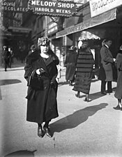
UW Library originally had this mis-identified as "outside Harold Week's The Melody Shop at 1408 2nd Ave." -
-
 https://digitalcollections.lib.washington.edu/digital/collection/seattle/id/4507
UW Library originally had this mis-identified as "outside Harold Week's The Melody Shop at 1408 2nd Ave." -
 https://digitalcollections.lib.washington.edu/digital/collection/seattle/id/4509
UW Library originally had this mis-identified as "outside Harold Week's The Melody Shop at 1408 2nd Ave." -
-

-

-
 https://digitalcollections.lib.washington.edu/digital/collection/seattle/id/4542
Crossing University Street. Friedlander and Son Jeweler on the corner. -

-
 https://digitalcollections.lib.washington.edu/digital/collection/seattle/id/4567
The base of Friedlander's clock at left; a good view of that Phillips shoe sign. -
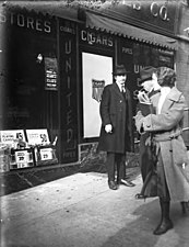
 https://digitalcollections.lib.washington.edu/digital/collection/seattle/id/4511 United Cigar Stores on the northeast corner of Second and Union in the building that had recently (until 1916) been the Seattle Times Building.
 -
 https://digitalcollections.lib.washington.edu/digital/collection/seattle/id/4513
A few more angles on that building, diverting slightly onto Union Street -

-

-
 https://digitalcollections.lib.washington.edu/digital/collection/seattle/id/4512
The UW Libraries had this one flopped left-right… -
 … so it looked like this.
 -

-
 https://digitalcollections.lib.washington.edu/digital/collection/seattle/id/4561
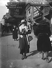
Back on Second (1400 block, between Union and Pike), outside Harold Weeks's The Melody Shop at 1408 2nd Ave. -
-

-

-

-
-

-

-
 https://digitalcollections.lib.washington.edu/digital/collection/seattle/id/4302
Outside MacDougall and Southwick, just south of Pike Street -
 https://digitalcollections.lib.washington.edu/digital/collection/seattle/id/4522
Corner of Pike Street. Built in the 1890s as a three-story Masonic Temple on the northeast corner of Second & Pike, the building closest here became the People's Savings Bank in March 1900; three more stories were added in 1905. The building was torn down some time in the mid-20th Century. Designed by Bebb & Mendel.
.jpg)
.jpg)
.jpg)
.jpg)
.jpg)
.jpg)
.jpg)
.jpg)
.jpg)
.jpg)
.jpg)
.jpg)
.jpg)
.jpg)
.jpg)
.jpg)
.jpg)
.jpg)
.jpg)
.jpg)
.jpg)
.jpg)
.jpg)
.jpg)
.jpg)
.jpg)
.jpg)
_(flop_corrected).jpg)
.jpg)
.jpg)
.jpg)
.jpg)
.jpg)
.jpg)
.jpg)
.jpg)
.jpg)
.jpg)
.jpg)
.jpg)
And a few taken on the west side of the Second, also all looking north. These are all taken just south of Piper & Taft Sporting Goods, 1117 Second Avenue; their sign is visible. Savoy Hotel visible at right.
.jpg)
.jpg)
.jpg)
.jpg)
There are a number of photos looking eastward on Pike from the crosswalk on the south side Third Avenue. I had to look at these quite a bit before I worked it out. Partly that was because the photo that best pins down the location was flopped left-right on the UW Library website:
-
 https://digitalcollections.lib.washington.edu/digital/collection/seattle/id/4547
showed this, which had me thinking first of the Prefontaine Building south of Yesler, but it didn't quite fit until I realized… -
 … that the image is really like this, and that is the Northern Bank and Trust Building, still around as the Seaboard Building, on the east side of what was then the south terminus of Westlake Avenue and is now Westlake Park, at Fourth and Pike.
.jpg)
_(flop_corrected).jpg)
_-_borders_removed.jpg)
Once I worked that out, I could make sense of these. There must have been an Owl Drug Co. store at the southeast corner of Third and Pike prior to the one that opened up at the end of 1918 or beginning of 1919 in the Silverstone Building, a flatiron building that was just west of Frederick and Nelson (now Nordstrom) in the triangle between Westlake Avenue and Fifth Avenue, just north of Pine Street. The two locations are so close together that it seems unlikely they were open at the same time, so these photos are probably all in the first half of the 1917-1920 window for the set.
Anyway, all of the following look eastward on Pike from the crosswalk on the south side Third Avenue:
.jpg)
.jpg)
.jpg)
.jpg)
.jpg)
.jpg)
.jpg)
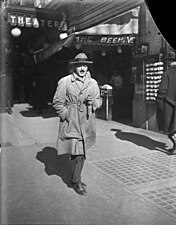
Looking east on the south side of Pine Street; crosswalk in foreground crosses Third Avenue. That's Sherman Clay Co. (piano shop) on the southeast corner of Third and Pike; they would soon move to Fourth Avenue between Pine and Stewart, and remain there for almost a century. In most of these, the Frederick & Nelson store (now Nordstrom) at Fifth and Pine is visible at left.
-
 File:Women crossing downtown street, Seattle, ca 1917-ca 1920 (SEATTLE 4524) (flop corrected).jpg
UW Library had this flopped left-right… -
 …so it looked like this.
 -

-

-

-
-

-
 https://digitalcollections.lib.washington.edu/digital/collection/seattle/id/4353
This picture by Scott, taken from a bit higher up at the same streetcorner, provides some interesting context. A big sign protrudes from the Sherman Clay store at the corner; at left is Seattle Fire Station 2 (built 1906) which would be torn down in the late 1920s to build the Bon Marché, later a Macy's.
_(flop_corrected).jpg)
.jpg)
.jpg)
.jpg)
.jpg)
.jpg)
.jpg)
.jpg)
A block west of that, at Second and Pine, also looking east, we have MacDougall and Southwick on the southeast corner:
.jpg)
Three images here of a toy store window pretty much have to be on the southeast corner of Third Avenue and Stewart Street. In all but File:Window shoppers outside a toy store, Seattle, ca 1917-ca 1920 (SEATTLE 4397).jpg, the 1916 Seattle Times Building (a flatiron building still extant 2020 as Times Square Building) is visible at left. It looks like that is seen through a second window, not in reflection, and given the way the light falls, especially in File:Soldier with pipe window shopping alongside a woman and child and little girl at a toy store, Seattle, ca 1917-ca 1920 (SEATTLE 4361).jpg it has to be the south side of the Times Building. So this is taken standing on the east side of Third Avenue just south of Stewart Street, what would later be the northeast corner of the 1929 Bon Marché flagship store, later Macy's.
.jpg)
.jpg)
.jpg)
The Lyon Building at Third and James, and other nearby buildings.
-
 https://digitalcollections.lib.washington.edu/digital/collection/seattle/id/4395
This is the Lyon Building. You can see "Lyon" behind the woman's hat at left. The entrance has been somewhat remodeled since then, but the dimensions are the same. -
 https://digitalcollections.lib.washington.edu/digital/collection/seattle/id/4460
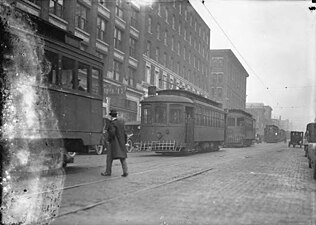
Streetcars along Third Avenue north of James Street. Left to right: Lyon Building, 607 Third Avenue, still extant 2020; St. Charles Hotel/Rector Hotel, 619 Third Avenue, still extant 2020; Ablemarle Hotel: this and the New York Block to its west were demolished in the 1920s to build the Dexter Horton Building. -
 https://digitalcollections.lib.washington.edu/digital/collection/seattle/id/4289
Third Avenue at James Street, looking northwest. The Lyon Building at left and the St. Charles Hotel / Rector Hotel next to that are still there in 2020, but the Ablemarle Hotel at right is gone. Along with the the New York Block, it was demolished to build the Dexter Horton Building.
.jpg)
.jpg)
.jpg)
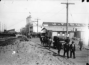
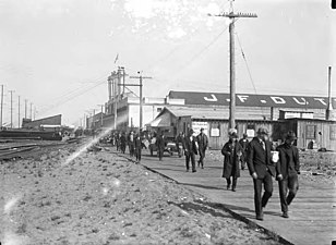
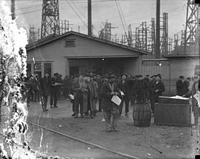
There are a number of examples of Scott's street photography along the waterfront south of Downtown:
-
 https://digitalcollections.lib.washington.edu/digital/collection/seattle/id/4470
The only clue to the location -- but it's a strong one -- is the Smith Tower in the distance at right. Based on the angle and the fact that this is from a low altitude with no other buildings visible, this was presumably on or near the waterfront, roughly at S. Connecticut St. (now S. Royal Brougham Way). -
 https://digitalcollections.lib.washington.edu/digital/collection/seattle/id/4448
"Whatcom Avenue" was the portion of what is now Alaskan Way S roughly between S Holgate Street and S Spokane Street, basically a southward continuation of Railroad Avenue through filled lands, along the filled east bank of the Duwamish Waterway. -
-
 https://digitalcollections.lib.washington.edu/digital/collection/seattle/id/4447
Todd Dry Docks Co. Presumably the former Moran Bros. shipyard on the Seattle waterfront between Connecticut Street (now South Royal Brougham Way) and South King Street (which became the Seattle Construction & Drydock Co. in 1912 and Todd in 1916), rather than one of the later Todd facilities on Harbor Island.
.jpg)
.jpg)
.jpg)
.jpg)
There are a few for which we only seem to have one or two photos Scott took at a particular location.
-
 https://digitalcollections.lib.washington.edu/digital/collection/seattle/id/4358
This is the entrance to the Olympic Block, which stood at the southeast corner of First and Yesler. Compare File:Olympic Block, southeast corner of 1st Ave S and Yesler Way, Seattle (CURTIS 2065).jpeg. -
 https://digitalcollections.lib.washington.edu/digital/collection/seattle/id/4318
This and the next show the old New York Block at the northeast corner of Second and Cherry, torn down in the late 1920s to build the present-day Dexter Horton Building. -
 https://digitalcollections.lib.washington.edu/digital/collection/seattle/id/4325
These look more posed than others in this collection. Possibly an engagement, or seeing someone go off to World War I? -
 https://digitalcollections.lib.washington.edu/digital/collection/seattle/id/4391
This is on the Third Avenue side of what was then the City-County Building and is now (2020) King County Courthouse. The plaque memorializing Henry Yesler (who once owned and resided on the land where the courthouse is located) is still there. -
 https://digitalcollections.lib.washington.edu/digital/collection/seattle/id/4382
Outside the Hoge Building (northwest corner of Second and Cherry), still extant 202. -
 https://digitalcollections.lib.washington.edu/digital/collection/seattle/id/4306
Outside Schoenfeld Building / Standard Furniture, now known as Broadacres Building. The clock was short-lived, but can be seen in the distance at https://cdm16118.contentdm.oclc.org/digital/collection/p15015coll4/id/2485/rec/1 -
 https://digitalcollections.lib.washington.edu/digital/collection/seattle/id/4385
South side of the 200 block of Pike Street, near Clifton Jewelry (who owned the clock) and Singerman's, in the former Hotel Snoqualmie building. -
 https://digitalcollections.lib.washington.edu/digital/collection/seattle/id/4354
Basically, what is now Westlake Park. -
 https://digitalcollections.lib.washington.edu/digital/collection/seattle/id/4475
Crowd gathered around trolley collision at 6th Ave and Pine St, Seattle… -
 https://digitalcollections.lib.washington.edu/digital/collection/seattle/id/4463
…presumably related to the former.
.jpg)
.jpg)
.jpg)
.jpg)
.jpg)
.jpg)
.jpg)
.jpg)
.jpg)
.jpg)
Unknown locations
[edit]This batch are all one location, but I haven't been able to pin down where; presumably looking north on a Downtown avenue:
.jpg)
.jpg)
.jpg)
.jpg)
.jpg)
.jpg)
Some of these are probably hopeless (where all we can see in the background is a trolley and maybe a bit of a roofline), but in theory we could still work out the rest of these.
-

-
-

-

-
 https://digitalcollections.lib.washington.edu/digital/collection/seattle/id/4390
I'd guess waterfront, but I can't prove it. -
 https://digitalcollections.lib.washington.edu/digital/collection/seattle/id/4454
Probably on the waterfront south of downtown, but so far I can't prove it. -
 https://digitalcollections.lib.washington.edu/digital/collection/seattle/id/4450
Same location as prior photo, but clearly at a different time. Looks like that is scaffolding for building a ship, which certainly limits the possible locations. -
 https://digitalcollections.lib.washington.edu/digital/collection/seattle/id/4393
Probably on the waterfront south of downtown, but so far I can't prove it. -

-

-
 https://digitalcollections.lib.washington.edu/digital/collection/seattle/id/4394
(same location as prior photo) -

-

-
 https://digitalcollections.lib.washington.edu/digital/collection/seattle/id/4303
(same location as prior photo) -
 https://digitalcollections.lib.washington.edu/digital/collection/seattle/id/4442
(presumably just to the right of those) -

-
 https://digitalcollections.lib.washington.edu/digital/collection/seattle/id/4562
In the distance, that appears to be the Schoenfeld Building (Standard Furniture, still extant 2020 as the Broadacres Building) and the New Washington Hotel (still extant 2020 as the Josephinum) so this is presumably looking north on Second Avenue; my gut says Seneca Street, which would mean the corner there was where the 1904 - 1914 Pantages Theatre had been; I don't really know what replaced that. -
 https://digitalcollections.lib.washington.edu/digital/collection/seattle/id/4331
sign: "Silk Shop". Starting in late 1918 or early 1919, the Silk Shop was in the Silverstone Building, a flatiron building between Westlake Avenue and Fifth Avenue just north of Pine Street (now - 2020 - part of Westlake Center), but this does not appear to be that location. Wherever this is, the shadows make it almost certain we are looking north. -

-
 https://digitalcollections.lib.washington.edu/digital/collection/seattle/id/4533
This and the next two appear to be the same place -

-

-
 https://digitalcollections.lib.washington.edu/digital/collection/seattle/id/4526
Might this be the same location as the background of the next two? -

-
 https://digitalcollections.lib.washington.edu/digital/collection/seattle/id/4298
Same location as the prior one -
-

-
 https://digitalcollections.lib.washington.edu/digital/collection/seattle/id/4398
San Francisco Oyster House and Day and Night Safe Deposit and Storage Co. San Francisco Oyster House. UW Library gives the address 202 Yesler Way, and indeed the San Francisco Oyster House was once located there. However, this doesn't particularly look like that location, and that building was razed no later than November 1911 to build the Smith Tower. -

-
 https://digitalcollections.lib.washington.edu/digital/collection/seattle/id/4363
Might not even be Seattle. -

-
-

-

-
 https://digitalcollections.lib.washington.edu/digital/collection/seattle/id/4314
In 1934 Fields Millinery was at 1303 Second Avenue, on the west side of Second Avenue just north of University Street. This may or may not be the same location. -

-

-
 https://digitalcollections.lib.washington.edu/digital/collection/seattle/id/4328
Appears to be the Smith Tower in the distance, so this is presumably looking south (very rare among this set) on Second Avenue. -

-
 https://digitalcollections.lib.washington.edu/digital/collection/seattle/id/4304
Probably the same location as the previous one -
 https://digitalcollections.lib.washington.edu/digital/collection/seattle/id/4543
Browning King was a chain of men's clothing stores. At one time they had a shop in the Arcade Building, but so far I can't confirm or refute that is where this one is. -

.jpg)
.jpg)
.jpg)
.jpg)
.jpg)
.jpg)
.jpg)
.jpg)
.jpg)
.jpg)
.jpg)
.jpg)
.jpg)
.jpg)
.jpg)
.jpg)
.jpg)
.jpg)
.jpg)
.jpg)
.jpg)
.jpg)
.jpg)
.jpg)
.jpg)
.jpg)
.jpg)
.jpg)
.jpg)
.jpg)
.jpg)
.jpg)
.jpg)
.jpg)
.jpg)
.jpg)
.jpg)
.jpg)
.jpg)
.jpg)
.jpg)
.jpg)
.jpeg)