Template:Potd/2010-02-12 (ca)
Jump to navigation
Jump to search
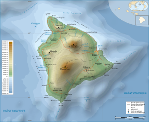


Mapa topogràfic de l'illa de Hawaii, mostrant un desnivell de 10.203 m entre el Mauna Kea i el fons de l'oceà.
This is the Catalan translation of the Picture of the day description page from 12 February 2010.
Mapa topogràfic de l'illa de Hawaii, mostrant un desnivell de 10.203 m entre el Mauna Kea i el fons de l'oceà.
Descriptions in other languages:
- Potd/2010-02-12 (bn)
- Potd/2010-02-12 (bs)
- Potd/2010-02-12 (ca)
- Potd/2010-02-12 (cs)
- Potd/2010-02-12 (da)
- Potd/2010-02-12 (de)
- Potd/2010-02-12 (en)
- Potd/2010-02-12 (es)
- Potd/2010-02-12 (fa)
- Potd/2010-02-12 (fi)
- Potd/2010-02-12 (fr)
- Potd/2010-02-12 (hu)
- Potd/2010-02-12 (it)
- Potd/2010-02-12 (ko)
- Potd/2010-02-12 (mk)
- Potd/2010-02-12 (nl)
- Potd/2010-02-12 (pam)
- Potd/2010-02-12 (pl)
- Potd/2010-02-12 (pt)
- Potd/2010-02-12 (ro)
- Potd/2010-02-12 (ru)
- Potd/2010-02-12 (sv)
- Potd/2010-02-12 (uk)
- Potd/2010-02-12 (zh-hans)
- Potd/2010-02-12 (zh-hant)