<nowiki>Siegsdorf; Siegsdorf; Siegsdorf; Siegsdorf; Siegsdorf; Siegsdorf; Siegsdorf; زیگسدورف; 西格斯多尔夫; Siegsdorf; Siegsdorf; ジークスドルフ; Siegsdorf; Siegsdorf; Зігсдорф; Зигсдорф; Siegsdorf; Зигсдорф; Siegsdorf; Siegsdorf; Siagsdorf; Siegsdorf; Siegsdorf; Զիգսդորֆ; Зигсдорф; Siegsdorf; Siegsdorf; Siegsdorf; Siegsdorf; Зигсдорф; Siegsdorf; Siegsdorf; Siegsdorf (munisipyo); Зигсдорф; Siegsdorf; Siegsdorf; Siegsdorf; Siegsdorf; Siegsdorf; Siegsdorf; Zygsdorfas; Зигсдорф; Siegsdorf; Siegsdorf; Siegsdorf; Siegsdorf; chemun de la Germania; település Németországban; Gemeinde im Landkreis Traunstein in Bayern; komunë në Gjermani; Şaredariyeke Almanyayê; občina v okrožju Traunstein na Bavarskem (Nemčija); gmejna w Bayerskej; obec v zemském okresu Traunstein v Německu; kommune i Tyskland; gemeente in Beieren; komunumo en Bavario, Germanio; commune allemande; Localidad en Baviera (Alemania); comune tedesco; municipality of Germany; بلدية في منطقة تراونشتاين، ألمانيا; kumun alaman; громада в Німеччині, федеральна земля Баварія</nowiki>
This is a gallery page containing specially selected image and media files. They have been chosen as highlights of a particular topic, but do not represent the full range of files that are available on Commons. For a wider selection of files connected with Siegsdorf, see Category:Siegsdorf.


 Lage
Lage Rathaus
 Wallfahrtskirche Maria Eck
 Klostergasthof Maria Eck
 Hammer — Schmiedstr. 1 (Schmied zu Reuth)
 Der Hauptort um 1900
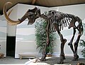 Siegsdorfer Mammut


_%E2%80%94_Mattes_2022-04-17.jpg)

