Satellite pictures of Taiwan
Jump to navigation
Jump to search
Taiwan Island
[edit]-
 NASA's Terra satellite (MODIS)

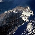
Chungyang Mountains
[edit]-
 Space Radar Map from NASA/ STS095-712-022/ Chungyang Mountains, Taiwan/ November 1998

Northern Area of Taiwan
[edit]-
 Space Radar Map from NASA/ STS066-089-069/ North Half of Taiwan/ November 1994

Taipei Area
[edit]-
 Taipei
 -
 The northern end of the island country of Taiwan, including the capital city of Taipei, is shown in this spaceborne radar image.
 -
 Space Radar Map by NASA/ STS068-239-090/ Taipei Area, Taiwan/ October 1994.


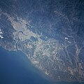
Kaohsiung Area
[edit]-
 Space Radar Map by NASA/ Kaohsiung Area, Taiwan/ October 2002
 -


