Rosengarten Forst, Lindenweg
Jump to navigation
Jump to search
| Object location | | View all coordinates using: OpenStreetMap |
|---|
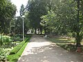
Deutsch: Diese Seite zeigt den Lindenweg im Rosenpark des Ostdeutschen Rosengartens Forst. Ein breiter Parkweg mit Winterlinden (Tilia cordata) an der Westseite verbindet den historischen Haupteingang am Rosenbrunnen mit der Brücke zur Wehrinsel.
English: This gallery shows the lime road on the rose park part of Ostdeutscher Rosengarten Forst in Forst (Lausitz). The park path with small-leaved limes on its western side runs from historical main entrance to a bridge to the Wehrinsel.
Lage des Lindenwegs
[edit]-
 Lageplan mit Markierung des Lindewegs

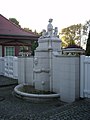
Rosenbrunnen
[edit]Deutsch: Am historischen Haupteingang beginnt bzw. endet der Verlauf der Lindenalle. Hier beginnt die Hauptachse des Rosenparks und mündet ein Querweg zum Neuheitengarten..
English: At the historical main entrance begins or finals the run of the lime alley and begins the major sight axis of the rose park. There is a crosscut to the novelties garden, too.
| Object location | | View all coordinates using: OpenStreetMap |
|---|
-
 Nordwestansocht (von außen)
 -
 Ostansicht
_-_geo.hlipp.de_-_39061.jpg)

Lindenweg von Nordnordwest
[edit]-
 Wegschild
 -
 südsüdostwärts vom nördlichen Querweg
 -
 südsüdostwärts vom zweiten Querweg
 -
 Skulptur „Mutter mit Kind“ (Ernst Sauer)
 -
 am Weg der Sommerblumengarten
 -
 links entfernt der Hochstammgarten
 -
 südsüdostwärts zum Cafe
 -
 rechts ein kleiner Rastplatz
 -
 Dahlien und Sommerblumen
 -
 rechts „Vogeltränke“ (Jürgen von Woyski)
 -
 links zur Kastanienallee
 -
 am Ende Wehrgraben-Brücke, zm Wehrinsel-Park


,_02.jpg)


_am_Lindenweg_beim_Cafe,_Sommer,_02.jpg)


Wasserspiele und Cafe
[edit]| Object location | | View all coordinates using: OpenStreetMap |
|---|
-
 links vorn weiter in den Lindenweg
 -
 vom Cafe nordostwärts
 -

-

_-_geo.hlipp.de_-_38943.jpg)
_Ostdeutscher_Rosengarten_Wasserspiele.JPG)
_-_geo.hlipp.de_-_38951.jpg)

Lindenweg von Südsüdost
[edit]-
 nach der Wehrgrabenbrücke rechts zur Kastanienallee, links Lindenweg
 -
 hinter dem Abzweig Kastanienallee
 -
bei den Wssserspielen
-
 rechts Teschendorff-Garten und Heidegarten
 -
 links „Vogeltränke“ von Jürgen von Woyski
 -
 rechts Dahlien- und Sommerblumengarten, Teil der Blumenrabatte
 -
 Dahlien- und Sommerblumengarten
 -
 Laube beim historischen Haupteingang
 -
 Baumhasel beim historischen Haupteingang
 -
 Baumhasel beim historischen Haupteingang


_am_Lindenweg_beim_Cafe,_Sommer,_01.jpg)


