Ridge Route
Jump to navigation
Jump to search
English: The Ridge Route, officially the Castaic-Tejon Route, is a narrow two-lane highway in the northern Greater Los Angeles Area of the U.S. state of California.
See also Category:Ridge Route.
-
 End County Maintained Road
 -
 Castaic Reservoir
 -
 historical marker missing its accompanying historical black and white photo
 -
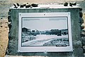
 National Forest Inn historical photo
 -
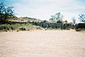
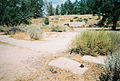
 National Forest Inn site panorama
 -
 National Forest Inn steps
 -
 Concrete curb on east side of Ridge Route
 -
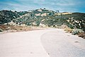
 Swede's Cut, looking north through the cut
 -
 Swede's Cut historical photo
 -
 One of the several turnouts found on the Ridge Route
 -
 Reservoir Summit - time to cool off
 -
 Geodetic Survey marker placed at foundation of water holding tank
 -
 Remains of something (not the reservoir) at Reservoir Summit
 -
 A Ridge Route rockslide to dodge
 -
 Halfway there!
 -
 Nothing left of Kelly's Halfway Inn
 -
 The Tumble Inn as it used to be
 -
 The Tumble Inn as it is today
 -
 "TUMBLE INN" inscribed in the cement step
 -
 The cement/asphalt road portions are obvious here
 -
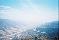
 Liebre Summit's famous Ridge Route view as it used to be
 -
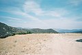
 Liebre Summit as it is today
 -
 Harold Sandberg's Summit Hotel as it was
 -
 The remains of Sandberg's Summit Hotel
 -
 Some of Sandberg's foundation has crumbled and caved in
 -
 The first guardrail one sees since the southern end's "End County Maintained Road"
 -
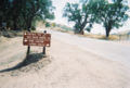 Northside entry and advisory signs - note the mileage figure to Castaic


.jpg)


