Plum Island (Massachusetts)
Jump to navigation
Jump to search
Plum Island (Massachusetts) is a barrier island between the mouth of the Merrimack River and the mouth of the Ipswich River.
| NO WIKIDATA ID FOUND! Search for Plum Island (Massachusetts) on Wikidata | |
| Upload media |
-
 Donald Wilkinson Bridge, only access by road to Plum Island.
 -
 Welcoming sign just past Wilkinson Bridge on the Plum Island Turnpike.
 -
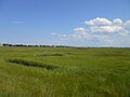 View of Great Marsh looking south from the Plum Island Turnpike. The distance on the left features part of the settled area; on the right, the federal reservation.
 -
 Looking north along the Plum Island River from the Wilkinson Bridge. The distance on the right shows part of the island's settlement; on the left, Newburyport Harbor.
 -
 The northern half of Plum Island Village seen from Wilkinson Bridge. The Plum Island River is in the foreground.
 -
 Satellite view. Newburyport Harbor is in the center. The southern tip of the island extends into Ipswich Bay. Plum Island Sound is on the inland side. The five rivers in it are the Plum Island, the Parker, the Rowley, the Eagle Hill and the Ipswich, north to south. Cape Ann juts out to the south.


