Photographs of Ladakh by Chris Hunkeler
-
 Chris Hunkeler in Markha Valley, Ladakh
 -
 Chris Hunkeler in Markha Valley, Ladakh
.jpg)
.jpg)
Leh གླེ
[edit]I spent a few days in Leh before starting the trek so that my body would adjust to the altitude.
Hotel Omasila
[edit]-
 2018-07-01 18:58
 -
 2018-07-01 19:03
 -
 2018-07-01 19:06
 -
 2018-07-01 19:07
.jpg)
.jpg)
.jpg)
.jpg)
-
 2018-07-02 09:26
 -
 2018-07-02 09:47
.jpg)
.jpg)
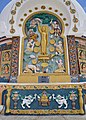
Shanti Stupa
[edit]-
 2018-07-02 10:52
 -
 2018-07-02 11:02
 -
 2018-07-02 11:39
 -
 2018-07-02 11:45:49
 -
 2018-07-02 11:47
 -
 2018-07-02 11:48
.jpg)
.jpg)
.jpg)

.jpg)
.jpg)
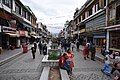
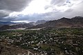
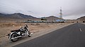
Downtown
[edit]-
 2018-07-02 12:26
 -
 2018-07-02 12:27
 -
 2018-07-02 12:28
 -
 2018-07-02 13:28
 -
 2018-07-02 14:16
 -
 2018-07-02 14:17
 -
 2018-07-02 14:32
.jpg)
.jpg)
.jpg)
.jpg)
.jpg)
.jpg)
.jpg)
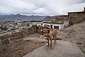
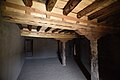
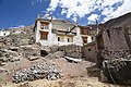
Leh Palace
[edit]-
 2018-07-02 14:32
 -
 2018-07-02 14:36
 -
 2018-07-02 14:42
 -
 2018-07-02 14:47
 -
 2018-07-02 14:50
 -
 2018-07-02 14:51
 -
 2018-07-02 14:54
 -
 2018-07-02 14:56
 -
 2018-07-02 15:16
 -
 2018-07-02 15:21
 -
 2018-07-02 15:34
 -
 2018-07-02 15:35
 -
 2018-07-02 15:51
 -
 2018-07-02 15:51
 -
 2018-07-02 15:55
 -
 2018-07-02 15:56
 -
 2018-07-02 15:59
 -
 2018-07-02 16:01
 -
 2018-07-02 16:02
 -
 2018-07-02 16:02
 -
 2018-07-02 16:06
 -
 2018-07-02 16:09
 -
 2018-07-02 16:09
 -
 2018-07-02 16:09
.jpg)
.jpg)
.jpg)
.jpg)
.jpg)
.jpg)
.jpg)
.jpg)
.jpg)
.jpg)
.jpg)
.jpg)
.jpg)
.jpg)
.jpg)
.jpg)
.jpg)
.jpg)
.jpg)
.jpg)
.jpg)
.jpg)
.jpg)
.jpg)
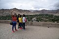
Namgyal Tsemo
[edit]-
 2018-07-02 16:48:08
 -
 2018-07-02 17:10
 -
 2018-07-02 17:12
 -
 2018-07-02 17:14
 -
 2018-07-02 17:15

.jpg)
.jpg)
.jpg)
.jpg)
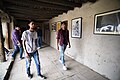
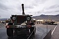
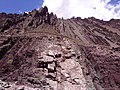
Hall of Fame
[edit]-
 2018-07-04 13:31
 -
 2018-07-04 13:33
 -
 2018-07-04 13:37
 -
 2018-07-04 13:37
 -
 2018-07-04 13:42
 -
 2018-07-04 13:43
 -
 2018-07-04 13:54
 -
 2018-07-04 14:24
.jpg)
.jpg)
.jpg)
.jpg)
.jpg)
.jpg)
.jpg)
.jpg)
Markha Valley Trek
[edit]1st day : 5 july 2018 - From Spituk to Zinchen
[edit]Zinchen (aka Zingchen / Zinchan / Jingchan)
[edit]ཞིང་ཆེན་ = big field, large field, farmland.
| Camera location | | View all coordinates using: OpenStreetMap |
|---|
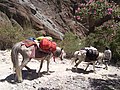
On day one, we drove from Leh to Spituk, stopping briefly for a few provisions along the way. From Spituk, we drove along Spituk-Zinchen Road and at some point, our driver stopped to drop off me and my guide, Sonam Gyalson. The idea was for the first day to be a test if I was even capable of walking a distance at altitude. We simply walked along Spituk-Zinchen Road until we got to our camping area shortly after 11 am. After a relaxing lunch, I explored the camp for a while and then wandered a little further afield along a mountainside. Sonam Gyalson follows Padma Yang Chen to her home to purchase mint and ginger so that he may brew tea for me. Later in the afternoon, I took tea by the stream.
-
 Indus River
2018-07-05 10:09 -
 approaching Zinchen
2018-07-05 10:52 -
 Zinchen oasis 2018-07-05 14:14
 -
 Padma Homestay 2018-07-05 14:23
 -
 Padma Homestay 2018-07-05 16:55
 -
 Zinchen oasis 2018-07-05 17:07
 -
 Zinchen 2018-07-05 17:18
 -
 Zinchen oasis 2018-07-05 17:41
.jpg)
.jpg)
.jpg)
.jpg)
.jpg)
.jpg)
.jpg)
.jpg)
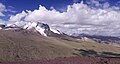
2nd day : 6 july 2018 - From Zinchen to Ganda La Base Camp
[edit]Rumbak - Yurutse - Ganda La Base Camp
[edit]-
 Rumbak 2018-07-06 11:02
 -
 Rumbak 2018-07-06 11:03
 -
 Rumbak 2018-07-06 11:04
 -
 Yurutse 2018-07-06 12:54
 -
 beyond Yurutse 2018-07-06 17:38
 -
 beyond Yurutse 2018-07-06 17:59
 -
 beyond Yurutse 2018-07-06 18:08
.jpg)
.jpg)
.jpg)
.jpg)
.jpg)
.jpg)
.jpg)
3rd day : 7 july 2018 - From Ganda La Base Camp to Skiu Campsite
[edit]Skiu (aka Skyu སྐྱུ)
[edit]Skyu-Kaya : སྐྱུ་ཀ་ཡ
-
 2018-07-07 14:05
vivo Y51L -
 Skiu (aka Skyu) 2018-07-07 15:17
vivo Y51L -
 Markha River 2018-07-07 17:23
 -
 Markha River 2018-07-07 17:26
.jpg)
.jpg)
.jpg)
.jpg)
4th day : 8 july 2018 - From Skiu to Markha མར་མཁའ / དམར་ཁ / མར་ཁ
[edit]-
 2018-07-08 08:10
 -
 irrigation channels (uras)
2018-07-08 08:15 -
 2018-07-08 09:41
 -
 2018-07-08 09:53
 -
 2018-07-08 09:55
 -
 2018-07-08 09:58
 -
 Footbridge 2018-07-08 10:02
 -
 Hamoursa Tea tent & Campsite in Nakdi 2018-07-08 10:13
 -
 Hamoursa Tea tent & Campsite in Nakdi 2018-07-08 10:14
 -
 2018-07-08 10:45
 -
 2018-07-08 10:49
 -
 Viewpoint 2018-07-08 11:03
 -
 2018-07-08 12:03
 -
 2018-07-08 12:05
 -
 2018-07-08 12:09
 -
 2018-07-08 12:12
 -
 Village Chalak (aka Chaluk) 2018-07-08 12:17
 -
 beyond Chalak 2018-07-08 12:26
 -
 2018-07-08 12:35
 -
 2018-07-08 12:36
 -
 Markha 2018-07-08 15:06
NIKON D810
.jpg)
.jpg)
.jpg)
.jpg)
.jpg)
.jpg)
.jpg)
.jpg)
.jpg)
.jpg)
.jpg)
.jpg)
.jpg)
.jpg)
.jpg)
.jpg)
.jpg)
.jpg)
.jpg)
.jpg)
.jpg)
5th day : 9 july 2018 - From Markha to Hangkar
[edit]Markha
[edit]-
 Markha 2018-07-09 08:29
vivo Y51L -
 Markha 2018-07-09 08:32
NIKON D810 -
 Markha 2018-07-09 08:36
NIKON D810 -
 Markha 2018-07-09 08:37
NIKON D810 -
 Markha 2018-07-09 08:37
NIKON D810 -
 Markha 2018-07-09 08:37
NIKON D810
.jpg)
.jpg)
.jpg)
.jpg)
.jpg)
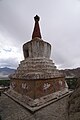
Techa Gompa (near Umlung འོ་མ་ལུང)
[edit]aka Tsetse / Tetsa / Tacha
| Camera location | | View all coordinates using: OpenStreetMap |
|---|
-
 2018-07-09 09:24
 -
 2018-07-09 09:48
 -
 2018-07-09 09:50
 -
 2018-07-09 09:58
 -
 2018-07-09 09:59
 -
 2018-07-09 10:01
 -
 2018-07-09 10:08
 -
 2018-07-09 10:14
.jpg)
.jpg)
.jpg)
.jpg)
.jpg)
.jpg)
.jpg)
.jpg)
Hankar (aka Hangkar)
[edit]The etymology of the last village in the direction of Nyimaling, Hankar, could come from གངས་ gangs, “glacier”, and དཀར་པོ་ dkar-po, “white”.(An Archaeological Account of the Markha Valley, Ladakh. By Quentin Devers and Martin Vernier, page 64)
| Camera location | | View all coordinates using: OpenStreetMap |
|---|
-
 Hankar (aka Hangkar)
2018-07-09 12:57 -
 2018-07-09 13:23
 -
 2018-07-09 13:26
 -
 2018-07-09 13:26
.jpg)
.jpg)
.jpg)
.jpg)
Tachungtse Camp
[edit]Ta-jung-tse / tha-chung-tse / thochuntse
ཐ་ཆུང = little one, very small
Other version བྲག་ཆུང takchung = little rock
རྩེ = peak
Ce tout petit sommet est sans doute celui que l'on peut voir juste au sud du camp, qui ressemble à une montagne miniature
| Camera location | | View all coordinates using: OpenStreetMap |
|---|
-
 2018-07-09 18:40
 -
 2018-07-09 18:40
 -
 2018-07-09 18:41
 -
 2018-07-09 18:47
.jpg)
.jpg)
.jpg)
.jpg)
6th day : 10 july 2018 - From Hangkar to Nimaling ཉི་མ་གླིང
[edit]-
 2018-07-10 09:12
vivo Y51L -
 2018-07-10 09:16
vivo Y51L -
 2018-07-10 09:17
vivo Y51L -

.jpg)
.jpg)
.jpg)
7th day : 11 july 2018 - From Nimaling to Chuskurmo via Kongmaru La
[edit]Kongmaru La Pass
[edit](aka Konmaru La / Gongmaru La)
-
 2018-07-11 09:11
vivo Y51L -
 2018-07-11 09:21
vivo Y51L -
 Kongmaru La
2018-07-11 09:39:17
vivo Y51L -
 Kongmaru La
2018-07-11 09:39:21
vivo Y51L -
 2018-07-11 09:46
vivo Y51L
.jpg)
.jpg)
.jpg)
.jpg)
.jpg)
-
 2018-07-11 12:09
vivo Y51L -
 Chuskurmo camp
2018-07-11 19:06
.jpg)
.jpg)
8th day : 12 july 2018 - From Chuskurmo to Shang Sumdo and return to Leh by jeep
[edit]Chuskurmo (aka Chu-skyur-mo which means sour water) Campsite
[edit]sources de sulfure d'hydrogène , gaz acide
| Camera location | | View all coordinates using: OpenStreetMap |
|---|
-
 Chuskurmo camp
2018-07-12 07:59 -
 2018-07-12 08:36
 -
 2018-07-12 08:38
 -
 2018-07-12 08:40
.jpg)
.jpg)
.jpg)
.jpg)
Shang Sumdo
[edit]| Camera location | | View all coordinates using: OpenStreetMap |
|---|
-
 Shang Sumdo
2018-07-12 08:56 -
 Shang Sumdo
2018-07-12 09:02 -
 Shang Sumdo
2018-07-12 09:04 -
 Shang Sumdo
2018-07-12 09:04 -
 Shang Sumdo
2018-07-12 09:16 -
 Shang Sumdo
2018-07-12 10:28 -
 Shang Sumdo
2018-07-12 10:29 -
 Shang Sumdo
2018-07-12 10:33
.jpg)
.jpg)
.jpg)
.jpg)
.jpg)
.jpg)
.jpg)
.jpg)