Pfaffenhütchen (Euonymus europaeus) in Ruhland
Jump to navigation
Jump to search
| Object location | | View all coordinates using: OpenStreetMap |
|---|
Pfaffenhütchen (Euonymus europaeus) in Ruhland
[edit]Deutsch: Diese Seite zeigt Pfaffenhütchen oder Gewöhnlicher Spindelstrauch (Euonymus europaeus) in Ruhland mit Ortsteil Arnsdorf.
English: This gallery shows Euonymus europaeus or European spindle tree in Ruhland with urban district Arnsdorf.
Entwicklung zum Strauch
[edit]-
 Sämling
 -
 Bäumchen

jahreszeitliche Entwicklung
[edit]-
 fruchttragender Strauch im Herbst
 -

-
 Früchte am Zweig
 -


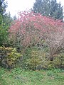
Strauch als Gestaltungselement
[edit]-
fruchttragender Strauch im Herbst
-
Krankheiten und Fehlbildungen
[edit]-
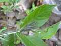 mit Pfaffenhütchen-Gespinstmotte
 -


