<nowiki>Pähl; Pähl; Pähl; Pähl; Pähl; Пель; Пэль; پل (شهر); Pähl; Pähl; ペール; Pähl; Пель; Пель; Pähl; Пель; Pähl; Пел; Pähl; Pähl; Pähl; Pähl; Пел; Pähl; Pähl; Pel; Pähl; Pähl; Пель; Pähl; پەل; Pelʹ; Pähl; Пел; Pähl; Pähl; Пель; Պել; Pähl; Pähl; Pähl; Pähl; Pähl; Pähl; Пель; Pähl; Pähl; باهل; Πελ; Pähl; comune tedesco; commune allemande; gmejna w Bayerskej; komunë në Gjermani; Şaredariyeke Almanyayê; munisipyo; Gemeinde im oberbayerischen Landkreis Weilheim-Schongau; kommune i Tyskland; gemeente in Beieren; municipio del distrito de Weilheim-Schongau, Alta Baviera, estado federado de Baviera, Alemania; sídlo ve spolkové zemi Bavorsko v Německu; település Németországban; بلدة ألمانية في ولاية بافاريا; municipality of Germany; komunumo en Bavario, Germanio; kumun alaman; громада в Німеччині, федеральна земля Баварія; Pahl; Vorderfischen; Fischen am Ammersee; Пäҳл; Пел; Pahl; Pel; Paehl; Pähl; Pahl; Paehl</nowiki>


 Lage
Lage Ortsansicht von Osten
 Pfarrkirche St. Laurentius
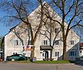 ehem. Mühlengebäude
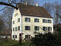 ehemaliges Wasserschloss, sogenanntes Unteres Schloss
 Hochschloss
 Blick auf Pähl von der Hirschberg-Alm
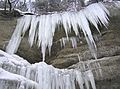 vereister Wasserfall in der Pähler Schlucht


