Old maps of Saint Petersburg
Jump to navigation
Jump to search

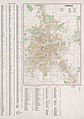
This gallery presents high-resolution maps of the entire city of Saint Petersburg in different periods of its history.
18th century
[edit]-
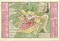
 1734 (in German)
 -
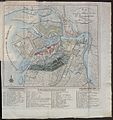
 1737 (in Russian/German)
 -
 1776 (in Russian/French)
 -
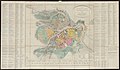
 1792
1792

.jpg)


19th century
[edit]-
 1800 (in German)
 -
 1810
1810 -
 1813 (in German)
 -
 1814 (in French)
 -
 1820 (in Russian/French)
 -
 1820
1820 -
 1832 (in Russian/French)
 -
 1833 (in French)
 -
 1842 (in French)
 -
 1849 (in German)
 -
 1852
1852 -
 1860
1860 -
 1866 (in German)
 -
 1880
1880 -
 1887
1887 -
 1889
1889 -
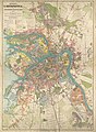
 1897
1897 -
 ?
?


20th century
[edit]-
 1910
1910 -
 1912
1912 -
 1916
1916 -
 1927
1927 -
 1933
1933 -
 1941 (in German)
 -
 1956 (in English)


