New Routemaster: Maps
Maps relating to the New Routemaster.
London route maps
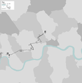
[edit]Maps showing individual London routes worked by the type, including out of service turning mileage, first/last stops, and operating garage/s (but not the out of service routes used to get to/from the garage if not run as part of the turning mileage), all on a background showing the London borough boundaries and the River Thames.
(N-prefixed routes not currently mapped)
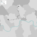
Normal frame
[edit]Sized to best show the route.
-
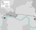
 Route 8 at conversion
 -
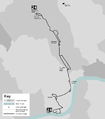
 Route 9 at conversion
 -
 Route 10 at conversion
 -
 Route 11 at conversion
 -
 Route 12 at conversion
 -
 Route 15 at conversion
 -
 Route 24 at conversion
 -
 Route 38 at conversion
 -
 Route 55 at conversion
 -
 Route 73 at conversion
 -
 Route 137 at conversion
 -
 Route 148 at conversion
 -
 Route 390 at conversion
 -
 Route 453 at conversion


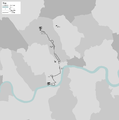
Full frame
[edit]Framed to fit the same area used for the network maps (below).
-
 Route 8 at conversion
 -
 Route 9 at conversion
 -
 Route 10 at conversion
 -
 Route 11 at conversion
 -
 Route 12 at conversion
 -
 Route 15 at conversion
 -
 Route 24 at conversion
 -
 Route 38 at conversion
 -
 Route 55 at conversion
 -
 Route 73 at conversion
 -
 Route 137 at conversion
 -
 Route 148 at conversion
 -
 Route 390 at conversion
 -
 Route 453 at conversion
.png)
.png)
.png)
.png)
.png)
.png)
.png)
.png)
.png)
.png)
.png)
.png)
.png)
.png)
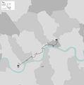
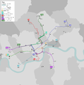
London network maps
[edit]Maps showing more than one of the London routes worked by the type as a network, including out of service turning mileage, first/last stops, and operating garage/s (but not the routes to/from the garage), all on a background showing the London borough boundaries and the River Thames. These network maps don't include the N-prefixed routes, as they run far further than the daytime/24 hour routes.
Iterative
[edit]Network maps with individual routes rendered in different colours. Each map is displayed below in the order of the progression of the rollout programme.
-
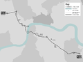
 Just after conversion of route 24
 -
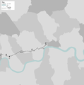
 Just after conversion of route 11
 -
 Just after conversion of route 9
 -
 Just after conversion of route 390
 -
 Just after conversion of route 148
 -
 Just after conversion of route 10
 -
 Just after conversion of route 38
 -
 Just after conversion of route 8
 -
 Just after conversion of route 453
 -
 Just after conversion of route 137


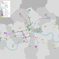
Current network
[edit]Below is the map currently pointed to by the redirect File:NRM maps - network current.png. By editting this redirect, it can be used in places where it's desireable to display the most up to date of the iterative network maps given above.
Other London maps
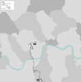
[edit]Current and former operating garages
[edit]Map showing the location of the current and former operating garages used to house the type in London in routine overnight storage, using the same basic backdrop as the network maps. As it included current and former garages, it's expected that this map will be periodically over-written to reflect subsequent changes.
