<nowiki>Nersingen; Nersingen; Nersingen; Nersingen; Nersingen; Nersingen; Nersingen; Ներզինգեն; 内尔辛根; Nersingen; Nersingen; 內爾辛根; Nersingen; Нерзінген; Нерзинген; 內爾辛根; Nersingen; Nersingen; Нерзинген; Nersingen; Nersingen; Nersingen; Nersingen; 内尔辛根; Нерзинген; Нерсинген; Nersingen; Nersingen; نەرزىينگەن; Nerzïngen; Nersingen; Нерсинген; Нерзинген; Nersingen; Nersingen; Nersingen; Nersingen (munisipyo); Nersingen; Nersingen; Nersingen; Нерзинген; نرزینگن; Нерзинген; Nersingen; Nersingen; Nersingen; Nersingen; Nersingen; chemun de la Germania; település Németországban; Gemeinde in Deutschland; komunë në Gjermani; Şaredariyeke Almanyayê; localitate din districtul Neu-Ulm, landul Bavaria, Germania; gmejna w Bayerskej; obec v zemském okresu Neu-Ulm v Německu; kommune i Tyskland; gemeente in Beieren; komunumo en Bavario, Germanio; commune allemande; municipio de Alemania; kumun alaman; municipality of Germany; بلدية في ألمانيا; municipality of Germany; громада в Німеччині, федеральна земля Баварія; Нерсинген; Nerzingen; Нерзинген</nowiki>


 Lage im Landkreis Neu-Ulm
 Ortsansicht von Süden
 Museum für bildende Kunst
 Brunnen beim Rathaus
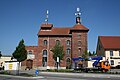 Bräuhaus Seybold
 Straß — St. Johann Baptist
 Oberfahlheim — katholische Pfarrkirche Sankt Dionysius


