Maps of municipalities in the Faroe Islands
Jump to navigation
Jump to search
Municipalities in the Faroe Islands
General
[edit]-
 Basic map with boundaries of January 1, 2009
 -
 Basic map with boundaries of January 1, 2005
 -
 Municipalities and regions with their names (2009)
 -
 Municipalities in the Faroe Islands - in different colors (2005)


-
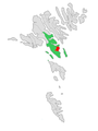
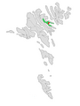
 Sunda kommuna. Note that Sunda kommuna was only situated on Eysturoy until 2005. Now it largely expanded over the northern part of Streymoy too.
 -

-

-
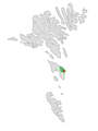
 Tórshavnar kommuna. The capital district.


Region of Northern Isles
[edit]


-
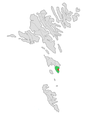
 Skopunar kommuna. Note that the islet Trøllhøvdi in the northwest is not part of this district. It belongs since generations to Kirkjubøur and now to Tórshavnar kommuna.
 -

-
-
-
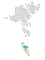
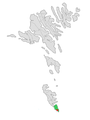
 Skúvoyar kommuna. Note that Stóra Dímun is part of the parish of Skúvoy.


The seven municipalities of Suðuroy could merge into one big district in the future. This is, however, not decided yet.
-
 Hvalbiar kommuna. Note that the island of Lítla Dímun is owned by farmers from Hvalba. Therefore, it is part of this parish.
 -
-

-

-
 Porkeris kommuna
 -

-


Former municipalities
[edit]-

-
-

-
 Klaksvíkar kommuna 2005–2009
 -

-

-
 Runavíkar kommuna 2005–2009
 -

-


