Maps of Sicily
Jump to navigation
Jump to search
Without legends
[edit]-

Position in Italy.
-
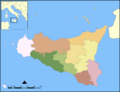
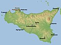
Map of the provinces
-

Topographical map
-

Physical map
-

Aeolian Islands
-

Aegadian Islands
-

Pelagie Islands
-

Ustica
-

Pantelleria
-

Marsala


With English legends
[edit]-

Map of the provinces
-

Physical map
-
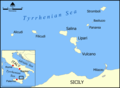
Aeolian Islands
-

Aegadian Islands
-

Pelagie Islands
-

Ustica
-

Pantelleria
-

Marsala


With Italian legends
[edit]-
 General map
 -
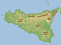
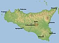
 Cities
 -
 Mountains
 -
 Rivers


Rivers
[edit]-
 Alcantara
 -
 Belice
 -
 Imera meridionale
 -
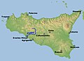 Platani


Mountains
[edit]-
 Etna
Etna -
 Monte Pellegrino


Mountain ranges
[edit]-
 Monti Peloritani
 -
 Monti Nebrodi
 -
 Madonie
 -
 Monti Sicani
 -
 Monti Erei
 -
 Monti Iblei


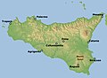
Provinces
[edit]


Others
[edit]-
 Historical map
 -
 Historical map showing the three "valli"
 -
 Historical map Hoefnagel- Blaeu
 -
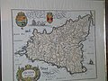 Historical map Hoefnagel - Blaeu


With German legends
[edit]-

Reliefkarte der Autonomen Region Sizilien
-

Karte aus Meyers Konversationslexikon
-

Karte zur Kolonisierung Siziliens
-

Äolische bzw. Liparische Inseln


