Maps of Nepal
Jump to navigation
Jump to search
- Maps are also available as part of the
 Wikimedia Atlas of the World project in the Atlas of Nepal.
Location and geographical maps
[edit]-
 Location map for Nepal
 -
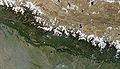 Satellite image of Nepal in October 2002
 -
 Geographic regions of Nepal


CIA World Factbook
[edit]-
 Karte Nepals
(German text) -
 Map of Nepal
(English text) -
 Mapa de Nepal
(Spanish text) -
 Carte du Népal
(French text)


.png)

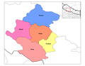
Provinces of Nepal
[edit]For each of the 7 Provinces of Nepal (wp-EN), the map is showing the provinces of Nepal.
-
 Bagmati Pradesh (wp-EN)
_Nepal.jpg)
Zones of Nepal
[edit]For each of the 14 zones of Nepal (wp-EN), the map is showing the districts incluede in the zone (4 to 8), with the English names of the districts.
-
 Bagmati Zone (wp-EN)
 -
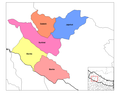 Bheri Zone (wp-EN)
 -
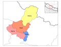 Dhawalagiri Zone (wp-EN)
 -
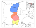
 Gandaki Zone (wp-EN)
 -
 Janakpur Zone (wp-EN)
 -
 Karnali Zone (wp-EN)
 -
 Koshi Zone (wp-EN)
 -
 Lumbini Zone (wp-EN)
 -
 Mahakali Zone (wp-EN)
 -
 Mechi Zone (wp-EN)
 -
 Narayani Zone (wp-EN)
 -
 Rapti Zone (wp-EN)
 -
 Sagarmatha Zone (wp-EN)
 -
 Seti Zone (wp-EN)


