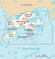
Maps of Hong Kong
Jump to navigation
Jump to search
中文:香港地圖。
English: Maps of Hong Kong.
Español: Mapas de Hong Kong.
- Maps are also available as part of the
 Wikimedia Atlas of the World project in the Atlas of Hong Kong.
Template maps
[edit]Historical maps
[edit]-
Victoria City and Kowloon of Hong Kong in 1915
-
Tsing Yi Island in Yuet Tai Kei
-
The location of Hong Kong, Macao and Canton
-
The location of Tsim Sha Tsui
-
Plan of the Kowloon Dockyard in the 1900s
-
Map of the Gin Drinkers Line
Geographic maps
[edit]-
Location of Hong Kong in the Pearl River Delta region
-
Latitude location of Hong Kong
-
Location map for Hong Kong
-
Location of Hong Kong in Southern China
-
CIA map of Hong Kong
-
CIA map of colonial Hong Kong
-
modified CIA map (in Hebrew)
-
CIA map of Hong Kong
-
Location of Kowloon
-
Surrounding Geography of Victoria Harbour
Cheung Chau
[edit]-
Cheung Chau
Kwai Tsing
[edit]Administrative maps
[edit]-
Regional Council and Urban Council
-
Hong Kong's Adminstrative districts
-
Kwai Tsing District
-
Location of Hong Kong in Guangdong
Functional maps
[edit]-
Hong Kong colonisation process (in Chinese)
-
Animated map of reclamation stages in Wan Chai


