Locator maps of counties in the Kingdom of Hungary
Jump to navigation
Jump to search
These are maps of the counties of the Kingdom of Hungary as of 1910, sorted alphabetically by their Hungarian name. Similar maps of the Croatian-Slavonian counties of the Kingdom of Hungary are available at English wikipedia, see the county articles in en:Category:Former counties of Croatia. Hungarian wikipedia has scanned old maps of the counties, see the county articles in hu:Kategória:A Magyar Királyság vármegyéi.
- Maps are also available as part of the
 Wikimedia Atlas of the World project in the Atlas of Hungary.
-
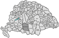
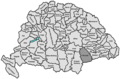
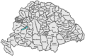
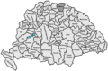
 Abaúj-Torna
 -
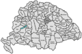
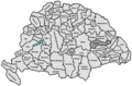
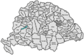
 Alsó-Fehér
 -
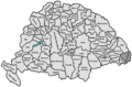
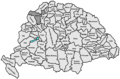
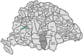
 Arad
Arad -
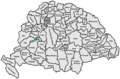
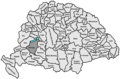
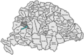
 Árva
Árva -
 Bács-Bodrog
 -
 Baranya
 -
 Bars
Bars -
 Békés
Békés -
 Bereg
Bereg -
 Beszterce-Naszód
 -
 Borsod
 -
 Brassó
 -
 Csanád
 -
 Csík
Csík -
 Csongrád
 -
 Esztergom
 -
 Fejér
Fejér -
 Fogaras
 -
 Gömör-Kishont
 -
 Győr
Győr -
 Hajdú
Hajdú -
 Háromszék
 -
 Heves
Heves -
 Hont
Hont -
 Hunyad
 -
 Jász-Nagykun-Szolnok
 -
 Kis-Küküllő
 -
 Kolozs
 -
 Komárom
 -
 Krassó-Szörény
 -
 Liptó
Liptó -
 Máramaros
 -
 Maros-Torda
 -
 Moson
Moson -
 Nagy-Küküllő
 -
 Nógrád
 -
 Nyitra
 -
 Pest-Pilis-Solt-Kiskun
 -
 Pozsony
 -
 Somogy
 -
 Sopron
 -
 Szabolcs
 -
 Szatmár
 -
 Szeben
 -
 Szilágy
 -
 Szolnok-Doboka
 -
 Temes
Temes -
 Tolna
Tolna -
 Torda-Aranyos
 -
 Torontál
 -
 Trencsén
 -
 Turóc
Turóc -
 Udvarhely
 -
 Ugocsa
 -
 Vas
Vas -
 Veszprém
 -
 Zala
Zala -
 Zólyom
 -
 Sáros
Sáros -
 Szepes
 -
 Ung
Ung -
 Zemplén


