<nowiki>Olpe; districte d'Olpe; Kreis Olpe; Olpe; اولپه (ناحیه); 奥尔珀县; Olpe; Olpe; オルペ郡; Kreis Olpe; Ольпе; Olpe; Olpe (Kris); Distrikto Olpe; Zemský okres Olpe; circondario di Olpe; arrondissement d'Olpe; Olpe kreis; Olpe; Kreis Olpe; اولپ; Olpe; Ольпе; Olpe; ოლპეს რაიონი; Olpe; Kreis Olpe; Olpe; Olpe; Olpe; Kreis Olpe; Powiat Olpe; Kreis Olpe; Kreis Olpe; Olpe; חבל אולפה; Olpe; ئۆلپ; Kreis Olpe; Olpen piirikunta; Kreis Olpe; Districto d'Olpe; Kuzey Ren-Vestfalya'da Kreis (kırsal bölge); ドイツの郡; arrondissement de Rhénanie-du-Nord-Westphalie; distrito de Alemania; जर्मनीको उत्तर राइन-वेस्टफेलिया रहेको जिल्ला; circondario della Germania; landkreis; район германии в Германии, Северный Рейн-Вестфалия; Kreis tl Nordrhein-Westfalen; südlichster Kreis des Sauerlandes im Reg.-Bez. Arnsberg in Nordrhein-Westfalen; piirikunta Saksassa; district in North Rhine-Westphalia, Germany; distrikto de Nordrejn-Vestfalio en Germanio; zemský okres ve spolkové zemi Severní Porýní-Vestfálsko v Německu; Navçeyeke Almanyayê; Olpe (district); Olpe district; Kreis Olpe</nowiki>


 Lage des Kreises Olpe in Deutschland
 Lage des Kreises Olpe in Nordrhein-Westfalen
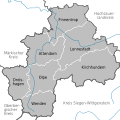 Städte und Gemeinden im Kreis Olpe


 Deutsch: Kreiswappen des Kreises Olpe (PNG-Version)
 Deutsch: Kreiswappen des Kreises Olpe (SVG-Version)