Jarrow Metro station
Jump to navigation
Jump to search
English: Jarrow 54°58′47″N 1°29′37″W / 54.979584°N 1.493567°W is a station on the Yellow Line of the Tyne and Wear Metro.
| Opened | New or converted |
Number of platforms | Track alignment | Tyne & Wear metropolitan borough |
| 24 March 1984 | Converted | 2 | NW-SE | South Tyneside |
| Layout | ||||
| Two side platforms at ground level, with platform level station buildings in the eastern half, with another single track passing to the north | ||||
| Platform no. and position |
Direction of travel M |
Previous stop |
Route | Next stop |
| Platform 1 North East |
SE bound | Hebburn | Yellow Line to South Shields (stop 37 of 42) | Bede |
| Platform 2 South West |
NW bound | Bede | Yellow Line to St James (stop 06 of 42) | Hebburn |
| Notes | ||||
| * M - these are compass headings, which in this station's case do not correspond to the directions diagrammatically indicated on the official Metro route map archive copy at the Wayback Machine - NW bound is Westbound & SE bound is Eastbound on the Metro map | ||||
| Station buildings | ||||
| Two simple square structures in the original style, both 20' by 20' | ||||
| Access | ||||
| Street level entrance from the south via a concrete apron next to the parallel Grant Street, with stairs up and down from a footbridge connecting the east platform ends, and which also continues north over the passing track to Sheldon Street & a bus station; also a 200' long ramp up from the east end of the north platform, in line with the track up to the SW-NE bridge for the A185 road over all the tracks | ||||
| Protection from the elements | ||||
| 60' platform shelters attached to the front of both station buildings | ||||
| Interchanges | ||||
| bus | ||||
-
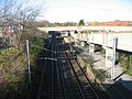 The view north west to the station from the A185 bridge, showing the ramp down to Platform 1 on the right
7 November 2009 -
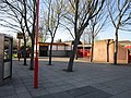 The view north across the Grant Street forecourt to the Platform 2 building
5 April 2012 -
 The view north across the Grant Street forecourt to the Platform 2 building
9 May 2007 -
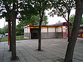
 The Platform 2 building from the forecourt onto Grant Street
9 May 2007 -
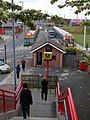 The view east down the steps from the station footbridge to the bus station directly ahead
16 July 2010 -
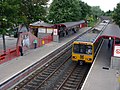 The view north west across the station from the footbridge; Metrocar No. 4018 is at the front of a train arriving in Platform 1, en route to South Shields
16 July 2010 -
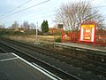
 The view north west from the end of Platform 2
5 January 2006 -
 The view north from Platform 2 across to the end of Platform 1
5 January 2006 -
 The view from an empty platform across to a Metrocar in the opposite platform
30 March 2006 -
 The view across the tracks
25 October 2006

.jpg)


.jpg)
.jpg)
.jpg)

