Hospitalstraße (Ruhland)
Jump to navigation
Jump to search
| Object location | | View all coordinates using: OpenStreetMap |
|---|
von der Bahnhofstraße nach Norden und wieder zurück
-
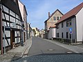 von der Bahnhofstraße nach Norden
rechts Mitte in die Bergstraße -
 hinter Kirchplatz 7
 -
 Hof hinter Hospitalstraße 9
hinten Pforte zum Stichweg zum Kirchplatz -
 bei Hausnr. 9
rechts Stichweg zum Kirchplatz -
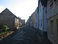
 zwischen Berg- und Bahnhofstraße
rechts in die Bahnhofstraße westwärts
links in die Bahnhofstraße ostwärts
geradeaus zum Brauhausplatz


