Gateshead Stadium Metro station
Jump to navigation
Jump to search
English: Gateshead Stadium 54°57′28″N 1°35′19″W / 54.9577°N 1.5885°W is a station on the Green & Yellow Lines of the Tyne and Wear Metro, near the Gateshead International Stadium.
| Opened | New or converted |
Number of platforms | Track alignment | Tyne & Wear metropolitan borough |
| 15 November 1981 | New | 2 | NW-SE | Gateshead |
| Layout | ||||
| An island platform in a cutting shared with a mainline double-track to the north, with a station building built over the southern track at the western end, and with a bridge for St James Road west of the platform end over both the Metro and mainline tracks | ||||
| Platform no. and position |
Direction of travel M |
Previous stop |
Route | Next stop |
| Platform 1 North East |
SE bound | Gateshead | Yellow Line to South Shields (stop 32 of 42) | Felling |
| Green Line to South Hylton (stop 16 of 31) | ||||
| Platform 2 South West |
NW bound | Felling | Yellow Line to St James (stop 11 of 42) | Gateshead |
| Green Line to Airport (stop 16 of 31) | ||||
| Notes | ||||
| * M - these are compass headings, which in this station's case do not correspond to the directions diagrammatically indicated on the official Metro route map archive copy at the Wayback Machine - NW bound is Westbound & SE bound is Eastbound on the Metro map | ||||
| Station buildings | ||||
| A simple rectangular structure in the original style (concrete/red), 50' by 30' | ||||
| Access | ||||
| Street level entrance from a station forecourt at the corner of St James Road/Shelley Drive (NW-SE) into the SW side of the building, with a ramp out of the SE side down the full platform length to platform level at the east end, and stairs down from the NW side | ||||
| Protection from the elements | ||||
| Station building underside & access ramp | ||||
| Interchanges | ||||
| None | ||||
-
 The view north east from Sunderland Road to the illuminated station building, centre right
8 January 2009 -
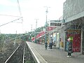
 The view south from the north end of the St James Road, over the mainline to the south eastern half of the platform
27 October 2005 -
 The view from the front of Metrocar No. 4089 as it enters Platform 1, en route to South Hylton
10 October 2005 -
 The view west across the south east end of the platform, as Metrocar No. 4077 forms the front half of a train in Platform 1 bound for South Shields, taken from a westbound Northern Rail train on the mainline (Class 155 DMU No. 156489)
10 October 2005 -
 The view north west from the rear of a Metrocar as it leaves Platform 1
1 January 2006 -
 The view south east from the rear of a Metrocar as it leaves Platform 2
2 January 2010 -
 The view south east from the end of the station platform, as a train approaches Platform 2 bound for Bank Foot
20 February 1985


