Frankfurter Stadtteilkarten
Jump to navigation
Jump to search
Deutsch: Karten der Frankfurter Stadtteile.
English: Locator maps of Frankfurt districts.
Français : Cartes des locations des quartiers de Francfort.
Nederlands: Kaarten van Frankfurt met de locatie van de wijken.
Allgemeines
[edit]-
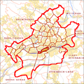
 Chronologie der Eingemeindungen
 -
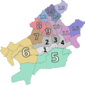 Ortsbezirke


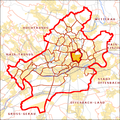
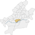
Innenstadt
[edit]English: Central districts
Français : Quartiers centrales
Nederlands: Wijken van de binnenstad
-
 Altstadt
 -
 Innenstadt
 -
 Bahnhofsviertel
 -
 Gutleutviertel
 -
 Gallusviertel
 -
 Westend
 -
 Westend
 -
 Nordend
 -
 Nordend
 -
 Ostend
 -
 Bornheim
 -
 Bockenheim
 -


Innere nördliche Stadtteile
[edit]English: inner northern districts
Français : Quartiers du nord interieur
Nederlands: Wijken in Oud-Noord
-
 Eschersheim
 -
 Dornbusch
 -
 Ginnheim
 -
 Eckenheim
 -
 Preungesheim
 -
 Berkersheim
 -
 Frankfurter Berg


Nordwestliche Stadtteile
[edit]English: north-western districts
Français : Quartiers du nord-ouest
Nederlands: noord-westelijke wijken
-
 Rödelheim
 -
 Hausen
 -
 Praunheim
 -
 Niederursel
 -
 Heddernheim


Äußere nördliche Stadtteile
[edit]English: Outer northern districts
Français : Quartiers du nord exterieur
Nederlands: Wijken in Nieuw-Noord
-
 Bonames
 -
 Harheim
 -
 Kalbach
 -
 Nieder-Eschbach
 -
 Nieder-Erlenbach


Östliche Stadtteile
[edit]English: Eastern districts
Français : Quartiers orientales
Nederlands: Oostelijke wijken
-
 Fechenheim
 -
 Bergen-Enkheim
 -
 Riederwald
 -
 Seckbach


Linkes Mainufer
[edit]English: Left bank
Français : Rive gauche
Nederlands: Linkeroever
-
 Sachsenhausen
 -
 Oberrad
 -
 Niederrad
 -
 Schwanheim
 -
 Flughafen


Höchst und Umgebung
[edit]English: Höchst and vicinity
Français : Höchst et banlieue
Nederlands: Höchst en omgeving
-
 Höchst
 -
 Unterliederbach
 -
 Zeilsheim
 -
 Sindlingen
 -
 Sossenheim
 -
 Nied
Nied -
 Griesheim
 -
 Innenstadt Höchst
 -
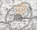
 Deutsch: Höchst und Umgebung, 1893English: Höchst and environments, 1893
 -
 Königsteiner Straße, 1893
 -
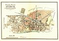
 Deutsch: Stadtplan von Höchst am Main aus dem Jahr 1850 mit Nachträgen aus dem Jahr 1864English: Town map of Höchst on Main from 1850 with addenda from 1864
 -
 Deutsch: Stadtplan von Höchst am Main aus dem Jahr 1897/1898English: Town map of Höchst on Main from 1897/1898


