File:Ziemie Czernihowsko-Siewierskie w XV wieku.jpg

Original file (4,384 × 4,189 pixels, file size: 4.47 MB, MIME type: image/jpeg)
Captions
Captions
Summary
[edit]| Description |
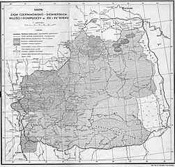
Polski: Mapa załączona do książki S. Kuczyńskiego «Ziemie Czernihowsko-Siewierskie pod rządami Litwy», wydanej w Warszawie w 1936 roku. Русский: Карта из книги Стефана Кучинского «Чернигово-Северские земли в составе Литвы», изданной в Варшаве в 1936 году. Українська: Мапа з книги Стефана Кучинського «Чернігово-Сіверські землі у складі Литви», виданої у Варшаві 1936 року. |
| Date | |
| Source | Ziemie Czernihowsko-Siewierskie pod rządami Litwy |
| Author | Stefan Maria Kuczyński |
| Other versions |

Licensing
[edit]
|
This work is in the public domain in its country of origin and other countries and areas where the copyright term is the author's life plus 70 years or fewer.
| |
| This file has been identified as being free of known restrictions under copyright law, including all related and neighboring rights. | |
File history
Click on a date/time to view the file as it appeared at that time.
| Date/Time | Thumbnail | Dimensions | User | Comment | |
|---|---|---|---|---|---|
| current | 13:48, 28 July 2011 | | 4,384 × 4,189 (4.47 MB) | Bornholm (talk | contribs) | {{Information |Description ={{pl|1=Mapa załączona do książki S.Kuczyńskiego "Ziemie czernihowsko-siewierskie pod rządami Litwy" wydanej w Warszawie w 1936 roku.}} |Source ="Ziemie czernihowsko-siewierskie pod rządami Litwy" |Author |
You cannot overwrite this file.
File usage on Commons
The following 2 pages use this file:
File usage on other wikis
The following other wikis use this file:
- Usage on azb.wikipedia.org
- Usage on az.wikipedia.org
- Usage on be.wikipedia.org
- Usage on cs.wikipedia.org
- Usage on de.wikipedia.org
- Usage on en.wikipedia.org
- Usage on es.wikipedia.org
- Usage on it.wikipedia.org
- Usage on lt.wikipedia.org
- Usage on pl.wikipedia.org
- Usage on pt.wikipedia.org
- Usage on ru.wikipedia.org
- Мценск
- Чернигов
- Гомель
- Черниговская область
- Старый Оскол
- Гомельская область
- Северщина
- Любеч
- Славгород (Белоруссия)
- Кромы
- Чечерск
- Севрюки
- Которь
- Трубчевское княжество
- Хвастовичи (Калужская область)
- Стрежев
- Елецкое княжество
- Глуховское княжество
- Еголдаева тьма
- Мезецкое княжество
- Устивское княжество
- Орля (Жиздринский район)
- Младшая ветвь Ольговичей
- Старшая ветвь Ольговичей
- Usage on sv.wikipedia.org
- Usage on tt.wikipedia.org
- Usage on uk.wikipedia.org
View more global usage of this file.