File:Yorkshire Dales map.xcf

Yorkshire_Dales_map.xcf (729 × 521 pixels, file size: 686 KB, MIME type: image/x-xcf)
Captions
Captions
|
|
| Description |
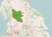
English: Overview map of the Yorkshire Dales National Park
Deutsch: Übersichtskarte des Yorkshire-Dales-Nationalparks |
|||||||||||||||
| Date | ||||||||||||||||
| Source |
|
|||||||||||||||
| Author | Kreuzschnabel | |||||||||||||||
| Permission (Reusing this file) |
I, the copyright holder of this work, hereby publish it under the following license: This file is licensed under the Creative Commons Attribution-Share Alike 3.0 Unported license.
|
|||||||||||||||
| XCF development |


File history
Click on a date/time to view the file as it appeared at that time.
| Date/Time | Thumbnail | Dimensions | User | Comment | |
|---|---|---|---|---|---|
| current | 05:53, 27 August 2016 |  | 729 × 521 (686 KB) | Kreuzschnabel (talk | contribs) | {{Information |Description ={{en|1=Overview map of the Yorkshire Dales National Park}} {{de|1=Übersichtskarte des Yorkshire-Dales-Nationalparks}} |Source ={{Openstreetmap}} |Author =Kreuzschnabel |Date... |
You cannot overwrite this file.
File usage on Commons
The following page uses this file:
File usage on other wikis
The following other wikis use this file:
- Usage on sh.wikipedia.org