File:Yobe Basin Koeppen.svg
Jump to navigation
Jump to search

Size of this PNG preview of this SVG file: 567 × 390 pixels. Other resolutions: 320 × 220 pixels | 640 × 440 pixels | 1,024 × 704 pixels | 1,280 × 880 pixels | 2,560 × 1,761 pixels.
Original file (SVG file, nominally 567 × 390 pixels, file size: 1.24 MB)
Captions
Captions
Add a one-line explanation of what this file represents
Summary
[edit]
| Description |
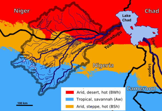
English: The Yobe basin overlaid with Köppen-Geiger climate classification. |
| Date | |
| Source | File:Koppen-Geiger_Map_Africa_present.svg |
| Author | Beck, H.E., Zimmermann, N. E., McVicar, T. R., Vergopolan, N., Berg, A., & Wood, E. F., Eric Gaba, Peter in s |
This file is licensed under the Creative Commons Attribution 4.0 International license.
- You are free:
- to share – to copy, distribute and transmit the work
- to remix – to adapt the work
- Under the following conditions:
- attribution – You must give appropriate credit, provide a link to the license, and indicate if changes were made. You may do so in any reasonable manner, but not in any way that suggests the licensor endorses you or your use.
File history
Click on a date/time to view the file as it appeared at that time.
| Date/Time | Thumbnail | Dimensions | User | Comment | |
|---|---|---|---|---|---|
| current | 07:19, 9 September 2019 | | 567 × 390 (1.24 MB) | Peter in s (talk | contribs) | {{Information |description ={{en|1=The Yobe basin overlaid with Köppen-Geiger climate classification.}} |date =2019-09-09 |source =https://commons.wikimedia.org/wiki/File:Koppen-Geiger_Map_Africa_present.svg |author =Beck, H.E., Zimmermann, N. E., McVicar, T. R., Vergopolan, N., Berg, A., & Wood, E. F., Eric Gaba, Peter in s }} {{Cc-by-4.0}} Category:Drainage basin maps of Africa |
You cannot overwrite this file.
File usage on Commons
The following page uses this file:
File usage on other wikis
The following other wikis use this file:
- Usage on de.wikipedia.org