File:Yemen. LOC 2002627680.tif
Jump to navigation
Jump to search

Size of this JPG preview of this TIF file: 800 × 545 pixels. Other resolutions: 320 × 218 pixels | 640 × 436 pixels | 1,024 × 697 pixels | 1,280 × 871 pixels | 2,560 × 1,743 pixels | 9,860 × 6,713 pixels.
Original file (9,860 × 6,713 pixels, file size: 189.37 MB, MIME type: image/tiff)
Captions
Captions
Add a one-line explanation of what this file represents
Summary
[edit]| Description |
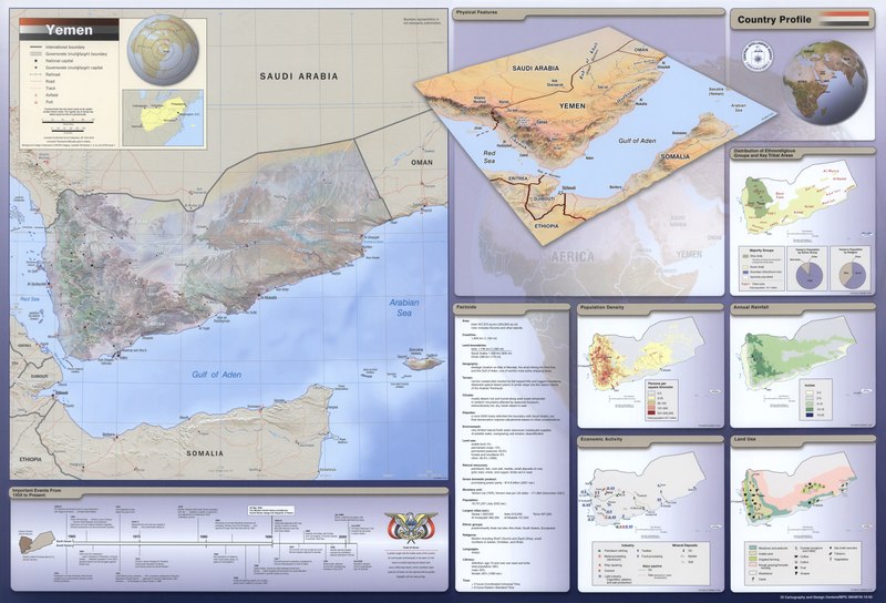
English: Relief shown by shading. "DI Cartography and Design Centers/MPG 386487AI 10-02." "761266AI 2-02." "Background image composed of AVHRR imagery, Landsat TM (bands 7, 4, 2), and DTED level 1." Includes comparative area map, 2 location maps, text, and historical timeline. Ancillary maps: Physical features -- Population density -- Economic activity -- Distribution of ethnoreligious groups and key tribal areas -- Annual rainfall -- Land use. Available also through the Library of Congress Web site as a raster image. |
||
| Title | Yemen. | ||
| Shelf ID | G7540 2002 .U53 | ||
| Date | |||
| Source | https://www.loc.gov/item/2002627680/ | ||
| Author | United States. Central Intelligence Agency. Cartography Center; United States. Central Intelligence Agency. Design Center | ||
| Permission (Reusing this file) |
|
||
| Other versions |
|
||
| Location | Yemen · Republic | ||
| Part of | American Memory · General Maps · Catalog · Geography And Map Division | ||
| Subject | Population Density · Rain And Rainfall · Religion · Land Use · Maps · Yemen (Republic) · Economic Conditions · Maps, Physical · Yemen · Ethnic Groups |


Licensing
[edit]| This image is a work of a Central Intelligence Agency employee, taken or made as part of that person's official duties. As a Work of the United States Government, this image or media is in the public domain in the United States.
|

|
File history
Click on a date/time to view the file as it appeared at that time.
| Date/Time | Thumbnail | Dimensions | User | Comment | |
|---|---|---|---|---|---|
| current | 10:11, 17 July 2018 |  | 9,860 × 6,713 (189.37 MB) | Fæ (talk | contribs) | LOC Maps https://www.loc.gov/item/2002627680/ #2136 |
You cannot overwrite this file.
File usage on Commons
The following page uses this file: