File:Yellowstone Major Calderas Map.jpg
Jump to navigation
Jump to search
Size of this preview: 750 × 600 pixels. Other resolutions: 300 × 240 pixels | 600 × 480 pixels | 960 × 768 pixels | 1,275 × 1,020 pixels.
Original file (1,275 × 1,020 pixels, file size: 310 KB, MIME type: image/jpeg)
Captions
Captions
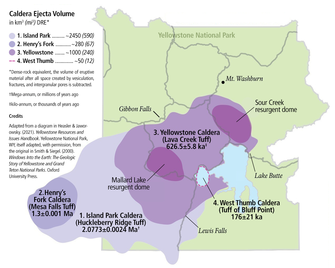
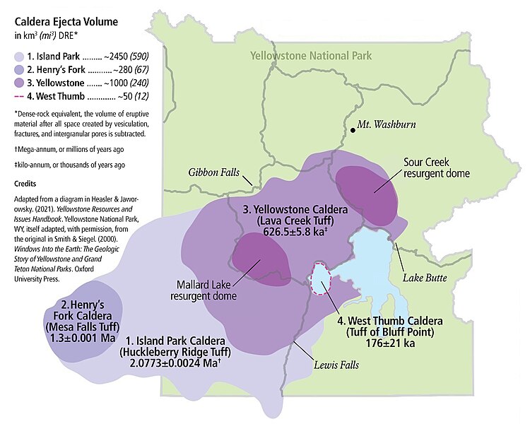
A map of four major calderas of the Yellowstone volcanic system within Yellowstone National Park
Summary
[edit]
| Description |
English: Depicted are four major calderas within the Yellowstone volcanic system, numbered in order of eruption: Island Park, Henry's Fork, Yellowstone, and West Thumb. Each caldera is additionally labeled with its associated ignimbrite/tuff deposit and high-precision U-Pb dates for each deposit from recent scientific literature. This is an improvement on the previous version of this diagram located here. The previous version was itself an adaptation of a diagram appearing in the 2021 National Park Service publication "Yellowstone Resources and Issues Handbook", itself adapted from the original diagram created in 2000 by Smith & Siegel for their book, "Windows Into the Earth: The Geologic Story of Yellowstone and Grand Teton National Parks". |
| Date | |
| Source | US NPS. |
| Author | w:National Park Service. |
| Permission (Reusing this file) |
w:United States federal government source. |
Licensing
[edit]
| This image or media file contains material based on a work of a National Park Service employee, created as part of that person's official duties. As a work of the U.S. federal government, such work is in the public domain in the United States. See the NPS website and NPS copyright policy for more information. |
File history
Click on a date/time to view the file as it appeared at that time.
| Date/Time | Thumbnail | Dimensions | User | Comment | |
|---|---|---|---|---|---|
| current | 12:41, 11 November 2023 | | 1,275 × 1,020 (310 KB) | Hermes Thrice Great (talk | contribs) | "by" → "in", in the "Credits" text |
| 18:20, 10 November 2023 |  | 1,275 × 1,020 (310 KB) | Hermes Thrice Great (talk | contribs) | Fixed an unfortunate typographical error in the diagram. | |
| 18:11, 10 November 2023 |  | 1,275 × 1,020 (310 KB) | Hermes Thrice Great (talk | contribs) | Uploaded own work with UploadWizard |
You cannot overwrite this file.
File usage on Commons
There are no pages that use this file.
File usage on other wikis
The following other wikis use this file:
- Usage on en.wikipedia.org
- Usage on uk.wikipedia.org
Metadata
Categories:
- Maps of Yellowstone Caldera
- West Thumb Caldera
- West Thumb Geyser Basin
- Maps of Yellowstone National Park
- Island Park Caldera
- Henry's Fork Caldera
- Huckleberry Ridge Tuff - maps
- Huckleberry Ridge Tuff
- Mesa Falls Tuff
- Lava Creek Tuff - maps
- Mesa Falls Tuff - maps
- Bluff Point Tuff - maps
- Volcanic centers
- Pleistocene volcanic rocks in the United States
- Pleistocene volcanoes in Wyoming
- Pleistocene volcanism of Wyoming
- Resurgent domes
- Resurgent calderas
- Maps of national parks of the United States
- Volcanological maps of Wyoming
- Rhyolitic tuff formations in the United States