File:Wpdms nasa topo missoula floods.jpg
Jump to navigation
Jump to search
No higher resolution available.
Wpdms_nasa_topo_missoula_floods.jpg (464 × 384 pixels, file size: 49 KB, MIME type: image/jpeg)
Captions
Captions
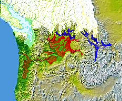
Topographic map of the Missoula and Columbia Floods

|
This map image could be re-created using vector graphics as an SVG file. This has several advantages; see Commons:Media for cleanup for more information. If an SVG form of this image is available, please upload it and afterwards replace this template with
{{vector version available|new image name}}.
It is recommended to name the SVG file “Wpdms nasa topo missoula floods.svg”—then the template Vector version available (or Vva) does not need the new image name parameter. |


Summary
[edit]
Glacial Lake Columbia (west) and Glacial Lake Missoula (east) are shown in blue, south of the Cordilleran Ice Sheet. The areas inundated during the Missoula Floods and Columbia Floods are shown in red.
© 2004 Matthew Trump.
http://en.wikipedia.org/wiki/Image:Wpdms_nasa_topo_missoula_floods.jpg
Licensing
[edit]

|
Permission is granted to copy, distribute and/or modify this document under the terms of the GNU Free Documentation License, Version 1.2 or any later version published by the Free Software Foundation; with no Invariant Sections, no Front-Cover Texts, and no Back-Cover Texts. A copy of the license is included in the section entitled GNU Free Documentation License. |
| This file is licensed under the Creative Commons Attribution-Share Alike 3.0 Unported license. | ||
| ||
| This licensing tag was added to this file as part of the GFDL licensing update. |
File history
Click on a date/time to view the file as it appeared at that time.
| Date/Time | Thumbnail | Dimensions | User | Comment | |
|---|---|---|---|---|---|
| current | 18:59, 7 January 2006 | | 464 × 384 (49 KB) | Mattes (talk | contribs) | new |
You cannot overwrite this file.
File usage on Commons
The following 2 pages use this file:
File usage on other wikis
The following other wikis use this file:
- Usage on de.wikipedia.org
- Usage on en.wikipedia.org
- Usage on es.wikipedia.org
- Usage on fr.wikipedia.org
- Usage on he.wikipedia.org
- Usage on it.wikipedia.org
- Usage on nl.wikipedia.org
- Usage on ro.wikipedia.org
- Usage on uk.wikipedia.org
- Usage on www.wikidata.org