Category:Maps of the Columbia River
Jump to navigation
Jump to search
Media in category "Maps of the Columbia River"
The following 63 files are in this category, out of 63 total.
-
 Columbia River Basin map-sr.svg 1,480 × 1,474; 1,014 KB
-
 ColumbiaRiverLocMap.png 500 × 500; 74 KB
-
 Columbiarivermap.png 1,500 × 1,500; 3.6 MB
-
 Columbiarivermap.svg 612 × 612; 15.91 MB
-
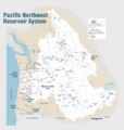 Pacific Northwest River System.png 1,930 × 2,032; 412 KB
-
 Kootenay River map with states and provinces.png 794 × 683; 89 KB
-
 Columbiawdams.png 948 × 1,230; 701 KB
-
 Columbia salmon accessibility.svg 808 × 790; 3.92 MB
-
 Columbiarivermapsnakeriverhighlighted.png 1,500 × 1,500; 3.43 MB
-
 1889 map of the Columbia River.jpg 8,861 × 10,074; 8 MB
-

-
 Admiralty Chart No 2839 Columbia River, Published 1897.jpg 16,277 × 10,929; 60.94 MB
-
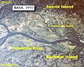 Bachelor and Sauvie Island map.jpg 500 × 400; 89 KB
-
 Bull run river oregon watershed map.png 710 × 420; 64 KB
-
 California fish and game (20325760210).jpg 1,802 × 1,434; 240 KB
-
 Clark Family Collection- Volume 4. Voorhis Journal No. 4, page 5, October 22-28, 1806.jpg 4,201 × 5,021; 5.22 MB
-
 Clark Family Collection- Volume 4. Voorhis Journal No. 4, page 6, October 22-28, 1806.jpg 4,202 × 4,885; 3.94 MB
-
 Clark Family Collection- Volume 4. Voorhis Journal No. 4, page 7, October 22-23, 1806.jpg 4,202 × 4,885; 8.48 MB
-

-
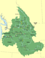
 Columbia Basin inside Columbia River Drainage Basin.png 2,000 × 2,000; 4.12 MB
-
 Columbia drainage basin blank map.png 808 × 790; 712 KB
-
 Columbia drainage basin major dams map-es.svg 808 × 790; 2.9 MB
-
 Columbia drainage basin major dams map-fr.svg 808 × 790; 3.72 MB
-
 Columbia drainage basin map-fr.png 808 × 790; 897 KB
-
 Columbia estuary administrative map-fr.svg 505 × 359; 3.3 MB
-
 Columbia estuary map-fr.svg 505 × 359; 4.69 MB
-
 Columbia gorge topographic map-fr.svg 682 × 359; 2.84 MB
-
 Columbia River Bar detail.jpg 1,289 × 1,032; 376 KB
-
 Columbia river bar.jpg 674 × 496; 152 KB
-
 Columbia River Mouth and Bar.jpg 3,957 × 2,557; 4.04 MB
-
 Columbia River route on satellite image.jpg 792 × 600; 120 KB
-
 Columbia River Slough (large).png 8,110 × 600; 10.71 MB
-
 Columbia River Slough (medium).png 4,055 × 300; 782 KB
-
 Columbiasloughwatershed.png 1,539 × 1,200; 302 KB
-

-
-
 Ginko Basalt flow.jpg 960 × 720; 66 KB
-
 Grand Coulee NASA.jpg 720 × 480; 537 KB
-
 Great Falls of Columbia River.png 1,804 × 845; 2.38 MB
-

-

-
 Kootenay River map.png 794 × 683; 85 KB
-
 Lake bonneville map.svg 663 × 570; 352 KB
-
 Lakes-Washington-Oregon-9.GIF 960 × 720; 319 KB
-
 Map missoula floods.gif 668 × 481; 24 KB
-
 Marcus (1942) Washington 1-125000 topographic quadrangles.jpg 2,000 × 2,418; 1.02 MB
-
 Mount Adams Region topographic map-fr.svg 751 × 870; 3.02 MB
-
 Multnomah County cadastral map, 1889.jpg 1,785 × 2,560; 770 KB
-
 PacificNW volcanics.png 449 × 637; 25 KB
-
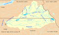
 Pendoreillerivermap.jpg 909 × 895; 1.01 MB
-
 Portland Census Map.pdf 5,404 × 4,800; 3.44 MB
-
 SauvieIsland.png 1,581 × 1,596; 105 KB
-
 St. Johns and Sauvie Island.png 916 × 2,244; 1.02 MB
-
 Tenasillahe Welch Islands.jpg 350 × 253; 18 KB
-
 The Columbia River Its History, Its Myths, Its Scenery, Its Commerce p 595.png 1,775 × 945; 2.59 MB
-
 The Commercial and financial chronicle (1910) (14741522986).jpg 2,538 × 4,188; 1.91 MB
-
 The Selkirk Mountains pg 146.jpg 2,510 × 2,105; 529 KB
-
 Un-Cruise Adventures - Legacy of Discovery (itinerary map).jpg 2,250 × 1,459; 1.99 MB
-
 Uw-archives map recon john day 1858.jpg 640 × 480; 106 KB
-
 Washington tribal territories map-fr.svg 1,031 × 675; 6.3 MB
-
 Waterville Plateau.jpg 515 × 697; 128 KB
-
 Wpdms nasa topo missoula floods.jpg 464 × 384; 49 KB
-
 Wpdms shdrlfi020l champoeg oregon.jpg 300 × 200; 32 KB


%27_(11006689714).jpg)


.jpg)


_Washington_1-125000_topographic_quadrangles.jpg)


_(14741522986).jpg)

.jpg)


.png)
.png)