File:Wilhelmshaven Innerer Hafen Karte.png
Jump to navigation
Jump to search
Size of this preview: 800 × 534 pixels. Other resolutions: 320 × 214 pixels | 640 × 427 pixels | 1,024 × 684 pixels | 1,280 × 854 pixels | 1,922 × 1,283 pixels.
Original file (1,922 × 1,283 pixels, file size: 1.2 MB, MIME type: image/png)
Captions
Captions
Add a one-line explanation of what this file represents
Summary
[edit]| Description |
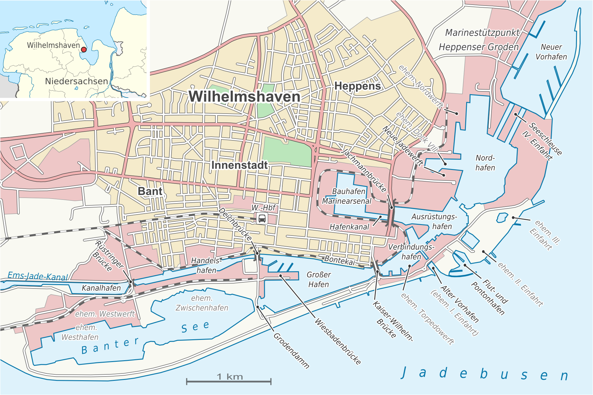
Deutsch: Detailkarte des inneren Hafenbereichs in Wilhelmshaven |
| Date | |
| Source |
own work, using |
| Author | Alexrk2 |
| Permission (Reusing this file) |
All OpenStreetMap data and maps are Creative Commons "CC-BY-SA 2.0" licensed |
| Other versions |
|


|
This map has been made or improved in the German Kartenwerkstatt (Map Lab). You can propose maps to improve as well.
|
Licensing
[edit]
I, the copyright holder of this work, hereby publish it under the following license:
This file is licensed under the Creative Commons Attribution-Share Alike 3.0 Unported license.
- You are free:
- to share – to copy, distribute and transmit the work
- to remix – to adapt the work
- Under the following conditions:
- attribution – You must give appropriate credit, provide a link to the license, and indicate if changes were made. You may do so in any reasonable manner, but not in any way that suggests the licensor endorses you or your use.
- share alike – If you remix, transform, or build upon the material, you must distribute your contributions under the same or compatible license as the original.
File history
Click on a date/time to view the file as it appeared at that time.
| Date/Time | Thumbnail | Dimensions | User | Comment | |
|---|---|---|---|---|---|
| current | 18:51, 2 August 2009 | | 1,922 × 1,283 (1.2 MB) | Alexrk2 (talk | contribs) | kw review no2; +Nordwerft; Hafenkanal |
| 13:13, 2 August 2009 |  | 1,922 × 1,283 (1.19 MB) | Alexrk2 (talk | contribs) | kw review no1; +Westhafen, Hafenkanal; 4. Einfahrt | |
| 17:29, 1 August 2009 |  | 1,922 × 1,283 (1.16 MB) | Alexrk2 (talk | contribs) | == Beschreibung == {{Information |Description={{de|Detailkarte des inneren Hafenbereichs in Wilhelmshaven}} |Source=|Source=own work, using * [http://www.openstreetmap.org Openstreetmap] data * File:Lower_Saxony_location_map.svg by [[:User:NordNordWe |
You cannot overwrite this file.
File usage on Commons
The following 4 pages use this file:
File usage on other wikis
The following other wikis use this file:
- Usage on de.wikipedia.org
- Usage on en.wikipedia.org
- Usage on lt.wikipedia.org
- Usage on www.wikidata.org
Categories:
- OpenStreetMap maps of Lower Saxony
- Maps of Wilhelmshaven
- Maps of Jadebusen
- Innenhafen Wilhelmshaven
- Marinestützpunkt Heppenser Groden
- Nordhafen (Wilhelmshaven)
- Großer Hafen (Wilhelmshaven)
- Kanalhafen (Wilhelmshaven)
- Handelshafen (Wilhelmshaven)
- Banter See
- Verbindungshafen (Wilhelmshaven)
- Ausrüstungshafen (Wilhelmshaven)
- Bauhafen (Wilhelmshaven)
- Alter Vorhafen (Wilhelmshaven)
- Flut- und Pontonhafen (Wilhelmshaven)