File:White Rock Mountain Water Tower, Forest Service Road 1505, Fern, Franklin County, AR HABS ARK,24-FERN,1- (sheet 5 of 6).tif
Jump to navigation
Jump to search

Size of this JPG preview of this TIF file: 400 × 600 pixels. Other resolutions: 160 × 240 pixels | 320 × 480 pixels | 512 × 768 pixels | 682 × 1,024 pixels | 1,365 × 2,048 pixels | 9,632 × 14,448 pixels.
Original file (9,632 × 14,448 pixels, file size: 974 KB, MIME type: image/tiff)
Captions
Captions
Add a one-line explanation of what this file represents
Summary
[edit]| Warning | The original file is very high-resolution. It might not load properly or could cause your browser to freeze when opened at full size. |
|---|
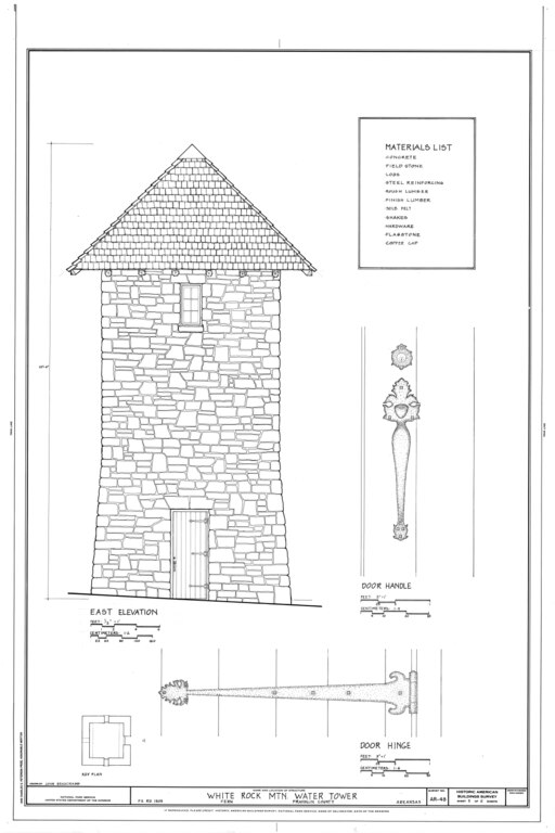
| HABS ARK,24-FERN,1- (sheet 5 of 6) - White Rock Mountain Water Tower, Forest Service Road 1505, Fern, Franklin County, AR | ||||
|---|---|---|---|---|
| Photographer |
Related names:
|
|||
| Title |
HABS ARK,24-FERN,1- (sheet 5 of 6) - White Rock Mountain Water Tower, Forest Service Road 1505, Fern, Franklin County, AR |
|||
| Depicted place | Arkansas; Franklin County; Fern | |||
| Date | Documentation compiled after 1933 | |||
| Dimensions | 24 x 36 in. (D size) | |||
| Current location |
Library of Congress Prints and Photographs Division Washington, D.C. 20540 USA http://hdl.loc.gov/loc.pnp/pp.print |
|||
| Accession number |
HABS ARK,24-FERN,1- (sheet 5 of 6) |
|||
| Credit line |
|
|||
| Notes |
|
|||
| Source | https://www.loc.gov/pictures/item/ar0125.sheet.00005a | |||
| Permission (Reusing this file) |
|
|||
| Other versions |
.png) .png) .png) .png) .png) .png) |
|||

| Object location | | View this and other nearby images on: OpenStreetMap |
|---|
File history
Click on a date/time to view the file as it appeared at that time.
| Date/Time | Thumbnail | Dimensions | User | Comment | |
|---|---|---|---|---|---|
| current | 15:30, 27 June 2014 |  | 9,632 × 14,448 (974 KB) | Fæ (talk | contribs) | GWToolset: Creating mediafile for Fæ. HABS batch upload 26 June 2014 (151:200) |
You cannot overwrite this file.
File usage on Commons
The following 2 pages use this file:
- File:HABS ARK,24-FERN,1- (sheet 5 of 6) - White Rock Mountain Water Tower, Forest Service Road 1505, Fern, Franklin County, AR HABS ARK,24-FERN,1- (sheet 5 of 6).tif (file redirect)
- File:White Rock Mountain Water Tower, Forest Service Road 1505, Fern, Franklin County, AR HABS ARK,24-FERN,1- (sheet 5 of 6).tif