File:West Mediterranean areas 348BC-fr.svg
Jump to navigation
Jump to search

Size of this PNG preview of this SVG file: 800 × 402 pixels. Other resolutions: 320 × 161 pixels | 640 × 322 pixels | 1,024 × 515 pixels | 1,280 × 643 pixels | 2,560 × 1,286 pixels | 812 × 408 pixels.
Original file (SVG file, nominally 812 × 408 pixels, file size: 1.12 MB)
Captions
Captions
Add a one-line explanation of what this file represents
| Description |
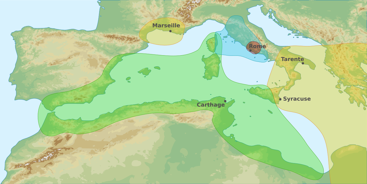
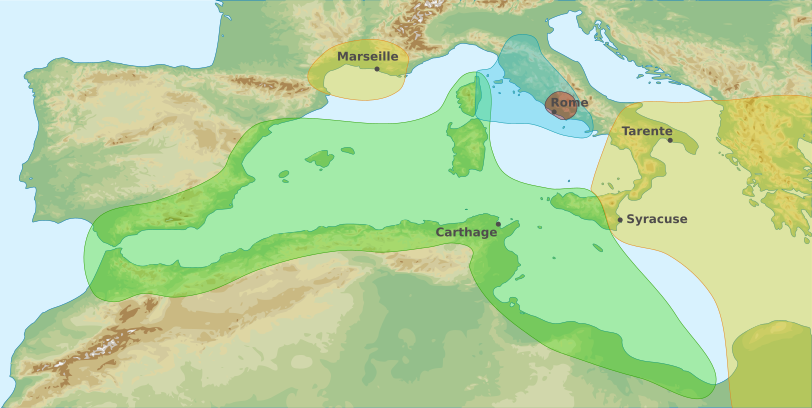
English: Map of area of influences in the Western Mediterranean Sea in 348 BC Français : Carte des zones d'influences dans l'Ouest de la Mer Méditerranée en 348 av. J-C Carthaginois Étrusques Grecs Romains |
| Date | (UTC) |
| Source | |
| Author |
|
| Other versions |
|
.svg)

Français : Cette carte a été créée par Pethrus d'après les sources mentionnés ci-dessus. Il s'agit d'un travail d'amateur, même s'il a été réalisé avec soin ; il peut comporter des inexactitudes ou des erreurs. Cette carte a donc un rôle d'illustration et non de référence. N'hésitez pas à me signaler toute erreur que vous constateriez ou à effectuer vous-même la correction. English: This map was drawn by Pethrus from sources mentionned above. Even if it was done with care, this is an amateur work ; there might be some inaccuracies or errors. As such, it should not be considered authoritative. Please contact me if you notice any mistake, and feel free to correct it yourself.
|

|
This SVG file contains embedded text that can be translated into your language, using any capable SVG editor, text editor or the SVG Translate tool. For more information see: About translating SVG files. |
I, the copyright holder of this work, hereby publish it under the following licenses:
This file is licensed under the Creative Commons Attribution-Share Alike 3.0 Unported, 2.5 Generic, 2.0 Generic and 1.0 Generic license.
- You are free:
- to share – to copy, distribute and transmit the work
- to remix – to adapt the work
- Under the following conditions:
- attribution – You must give appropriate credit, provide a link to the license, and indicate if changes were made. You may do so in any reasonable manner, but not in any way that suggests the licensor endorses you or your use.
- share alike – If you remix, transform, or build upon the material, you must distribute your contributions under the same or compatible license as the original.

|
Permission is granted to copy, distribute and/or modify this document under the terms of the GNU Free Documentation License, Version 1.2 or any later version published by the Free Software Foundation; with no Invariant Sections, no Front-Cover Texts, and no Back-Cover Texts. A copy of the license is included in the section entitled GNU Free Documentation License. |
You may select the license of your choice.
Original upload log
[edit]
This image is a derivative work of the following images:
- File:West_Mediterranean_Areas_348_BC.png licensed with PD-user
- 2006-07-14T09:22:39Z Horatius 1340x937 (2173031 Bytes) == Summary == Main areas of influence in West Mediterranean Sea in 348 BC. Principali aree di influenza nel Mediterraneo Occidentale nell'anno 348 aC (Secondo Trattato Roma-Cartagine). == Licensing == {{PD-user|Horatius}}
- File:West_Mediterranean_sea_topographic_map.svg licensed with Cc-by-sa-3.0,2.5,2.0,1.0, GFDL
- 2010-03-23T22:50:18Z Pethrus 812x408 (1161860 Bytes) {{Information |Description={{en|1=Topographic map of Western Mediterranean Sea}}{{fr|1=Carte topographique de l'Ouest de la Mer Méditerranée}} |Source=*[[:File:Western_Europe_DEMIS_topographic_map.svg|]], a DEMIS map {{inks
Uploaded with derivativeFX
File history
Click on a date/time to view the file as it appeared at that time.
| Date/Time | Thumbnail | Dimensions | User | Comment | |
|---|---|---|---|---|---|
| current | 21:16, 24 March 2010 | | 812 × 408 (1.12 MB) | Pethrus (talk | contribs) | {{Information |Description={{en|1=Map of area of influences in the Western Mediterranean Sea in 348 BC}}{{fr|1=Carte des zones d'influences dans l'Ouest de la Mer Méditerranée en 348 av. J-C {{legend|#A3EBA9|Carthaginois}}{{legend|#9BE1F5|Étrusques}}{{ |
You cannot overwrite this file.
File usage on Commons
The following 3 pages use this file:
File usage on other wikis
The following other wikis use this file:
- Usage on bg.wikipedia.org
- Usage on fr.wikipedia.org
- Usage on it.wikipedia.org