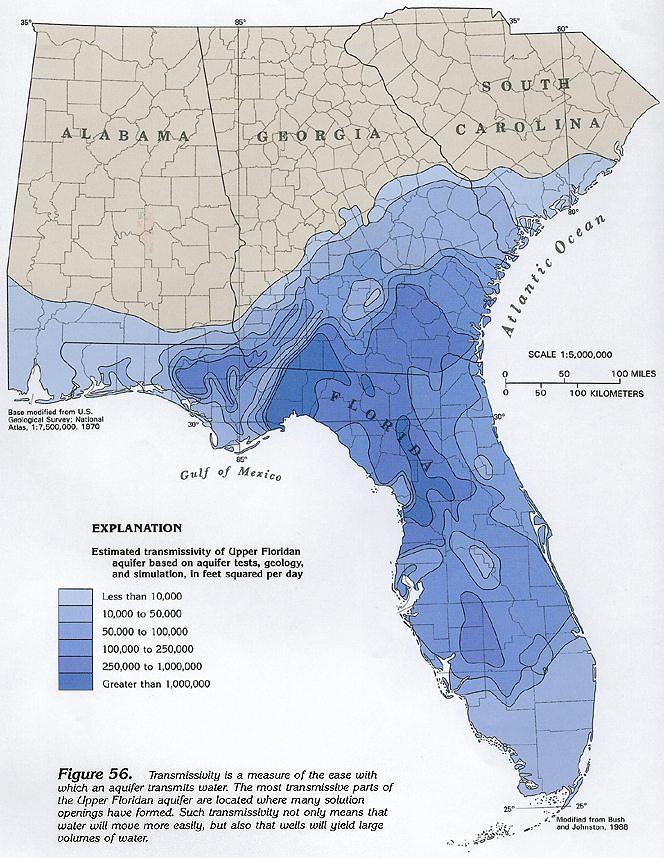
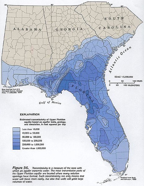
File:Wakulla Springs Flow Rate G056.jpg
Jump to navigation
Jump to search
Size of this preview: 464 × 600 pixels. Other resolutions: 186 × 240 pixels | 371 × 480 pixels | 664 × 858 pixels.
Original file (664 × 858 pixels, file size: 120 KB, MIME type: image/jpeg)
Captions
Captions
Add a one-line explanation of what this file represents
Summary
[edit]
| Description |
English:
|
| Source | http://pubs.usgs.gov/ha/ha730/ch_g/G-text6.html |
| Author | USGS |
Licensing
[edit]
This image is in the public domain in the United States because it only contains materials that originally came from the United States Geological Survey, an agency of the United States Department of the Interior. For more information, see the official USGS copyright policy.
|
Original upload log
[edit]
The original description page was here. All following user names refer to en.wikipedia.
- 2007-12-24 15:26 Noles1984 664×858× (123107 bytes) {{PD-USGov-Interior-USGS}}
File history
Click on a date/time to view the file as it appeared at that time.
| Date/Time | Thumbnail | Dimensions | User | Comment | |
|---|---|---|---|---|---|
| current | 21:52, 26 July 2010 | | 664 × 858 (120 KB) | File Upload Bot (Magnus Manske) (talk | contribs) | {{BotMoveToCommons|en.wikipedia|year={{subst:CURRENTYEAR}}|month={{subst:CURRENTMONTHNAME}}|day={{subst:CURRENTDAY}}}} {{Information |Description={{en|*'''Owner:''' US Geological Survey. "Most U.S. Geological Survey (USGS) information resides in the publ |
You cannot overwrite this file.
File usage on Commons
There are no pages that use this file.
File usage on other wikis
The following other wikis use this file:
- Usage on en.wikipedia.org
- Usage on fr.wikipedia.org
Metadata
Categories:
- Aquifers in the United States
- Hydrogeological maps of the United States
- Springs of the United States
- Geological maps of Florida
- Geography of Georgia (U.S. state)
- Maps of Mississippi (state)
- Geography of South Carolina
- Geology of Florida
- Geology of Georgia (U.S. state)
- Geology of Mississippi (state)
- Geology of South Carolina
- Hydrology of the United States
- Hydrology of Florida
- Hydrology of South Carolina
- Hydrology of Alabama
- Hydrology of Georgia (U.S. state)