File:Vertrag von Meerssen.svg
Jump to navigation
Jump to search

Size of this PNG preview of this SVG file: 600 × 600 pixels. Other resolutions: 240 × 240 pixels | 480 × 480 pixels | 768 × 768 pixels | 1,024 × 1,024 pixels | 2,048 × 2,048 pixels | 890 × 890 pixels.
Original file (SVG file, nominally 890 × 890 pixels, file size: 829 KB)
Captions
Captions
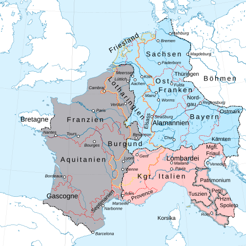
Franconian division of the empire according to the Treaty of Meerssen 870.
Summary
[edit]| Description |
Deutsch: Fränkische Reichsteilung nach dem Vertrag von Meerssen 870. English: Franconian division of the empire according to the Treaty of Meerssen 870.
Reich Ludwigs II / Empire of Ludwig
Reich Ludwigs des Deutschen / Kingdom of Ludwig the German
Reich Karls II., des Kahlen / Kingdom of Charles II, the Bald |
||
| Date | |||
| Source | This vector image includes elements that have been taken or adapted from this file: |
||
| Author | Furfur | ||
| Permission (Reusing this file) |
I, the copyright holder of this work, hereby publish it under the following licenses:
This file is licensed under the Creative Commons Attribution-Share Alike 4.0 International license.
You may select the license of your choice. |
||
| Other versions |
|
||
| SVG development | This map was created with Adobe Illustrator. |


File history
Click on a date/time to view the file as it appeared at that time.
| Date/Time | Thumbnail | Dimensions | User | Comment | |
|---|---|---|---|---|---|
| current | 13:46, 17 August 2019 | | 890 × 890 (829 KB) | Furfur (talk | contribs) | neue Farben, Details |
| 12:28, 11 August 2019 |  | 890 × 890 (737 KB) | Furfur (talk | contribs) | Detailfehler beseitigt | |
| 12:09, 11 August 2019 |  | 890 × 890 (739 KB) | Furfur (talk | contribs) | Kosmetik2 (Grenzlinin dünner) | |
| 21:24, 10 August 2019 |  | 890 × 890 (739 KB) | Furfur (talk | contribs) | falsche Datei :-( | |
| 21:23, 10 August 2019 |  | 890 × 890 (681 KB) | Furfur (talk | contribs) | Kosmetik | |
| 19:25, 10 August 2019 |  | 890 × 890 (730 KB) | Furfur (talk | contribs) | == {{int:filedesc}} == {{Information |Description={{User:Medium69/Traduction}} {{de|1=Fränkische Reichsteilung nach dem Vertrag von Meerssen 870.}} |Source={{AttribSVG|1=Fond de carte Tour de France-blank.svg|2=Sémhur}} |Date=2019-08-10 |Author={{U|Furfur}} |Permission={{self|GFDL|cc-by-sa-4.0}} |Other versions= |Other fields={{Igen|A|+|%|s=m}} }} Category:SVG maps showing history in German |
You cannot overwrite this file.
File usage on Commons
The following 2 pages use this file:
File usage on other wikis
The following other wikis use this file:
- Usage on de.wikipedia.org
- Usage on en.wikipedia.org
- Usage on es.wikipedia.org
- Usage on frr.wikipedia.org
- Usage on fr.wikipedia.org
- Usage on it.wikipedia.org
- Usage on ja.wikipedia.org
- Usage on sl.wikipedia.org
- Usage on www.wikidata.org
- Usage on zh.wikipedia.org