File:Verlaufskarte Scheldetalbahn.png
Jump to navigation
Jump to search

Size of this preview: 540 × 599 pixels. Other resolutions: 216 × 240 pixels | 433 × 480 pixels | 692 × 768 pixels | 1,034 × 1,147 pixels.
Original file (1,034 × 1,147 pixels, file size: 1.03 MB, MIME type: image/png)
Captions
Captions
Add a one-line explanation of what this file represents
Summary
[edit]
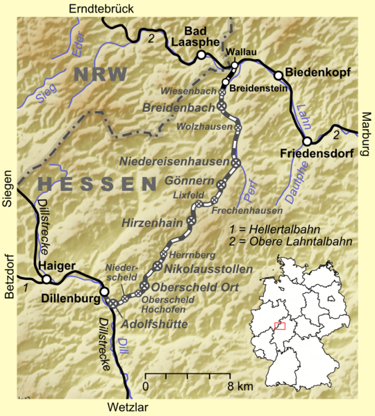
| Description | Verlaufskarte der Scheldetalbahn |
| Date | |
| Source |
own work, used:
|
| Author | Lencer |

|
This map has been made or improved in the German Kartenwerkstatt (Map Lab). You can propose maps to improve as well.
|
Licensing
[edit]
The map has been created with the Generic Mapping Tools: https://www.generic-mapping-tools.org/ using one or more of these public-domain datasets for the relief:
|

|
Permission is granted to copy, distribute and/or modify this document under the terms of the GNU Free Documentation License, Version 1.2 or any later version published by the Free Software Foundation; with no Invariant Sections, no Front-Cover Texts, and no Back-Cover Texts. A copy of the license is included in the section entitled GNU Free Documentation License. |
| This file is licensed under the Creative Commons Attribution-Share Alike 3.0 Unported license. | ||
| ||
| This licensing tag was added to this file as part of the GFDL licensing update. |
File history
Click on a date/time to view the file as it appeared at that time.
| Date/Time | Thumbnail | Dimensions | User | Comment | |
|---|---|---|---|---|---|
| current | 09:54, 8 July 2009 | | 1,034 × 1,147 (1.03 MB) | Lencer (talk | contribs) | fix -scheid => -scheld |
| 06:06, 8 July 2009 |  | 1,035 × 1,147 (1.03 MB) | Lencer (talk | contribs) | Bahn beginnt jetzt in Wallau | |
| 11:29, 2 July 2009 |  | 1,034 × 1,147 (1.04 MB) | Lencer (talk | contribs) | fixes | |
| 11:13, 2 July 2009 |  | 1,035 × 1,147 (1.03 MB) | Lencer (talk | contribs) | == Beschreibung == {{Information |Description=Verlaufskarte der Scheldetalbahn |Source=own work, used: * http://www.openstreetmap.org * Google Earth * Generic Mapping Tools |Date=2009-07 |Author=Lencer |Permission= | |
You cannot overwrite this file.
File usage on Commons
The following page uses this file:
File usage on other wikis
The following other wikis use this file:
- Usage on de.wikipedia.org
- Usage on www.wikidata.org