File:Van Karman Vortices off Guadalupe Island (MODIS 2021-05-10).jpg
Jump to navigation
Jump to search

Size of this preview: 744 × 599 pixels. Other resolutions: 298 × 240 pixels | 596 × 480 pixels | 954 × 768 pixels | 1,271 × 1,024 pixels | 1,923 × 1,549 pixels.
Original file (1,923 × 1,549 pixels, file size: 323 KB, MIME type: image/jpeg)
Captions
Captions
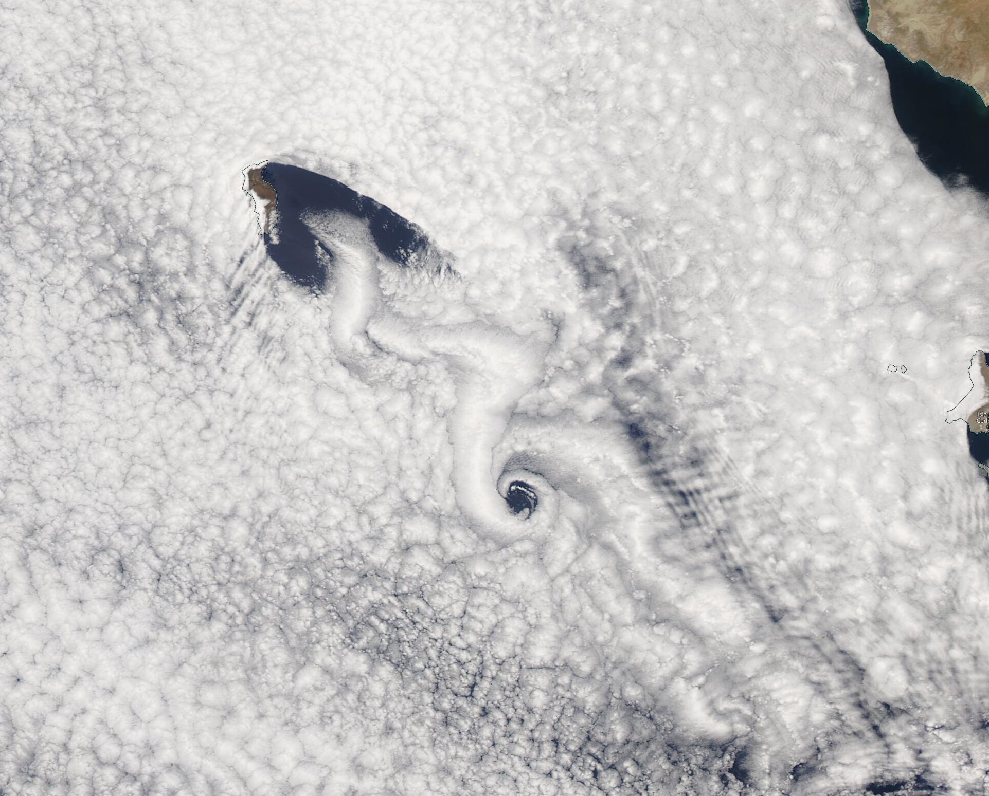
On May 3, 2021, the Moderate Resolution Imaging Spectroradiometer (MODIS) on board NASA’s Aqua satellite acquired a true-color image of such a moment when wind blowing past Guadalupe Island resulted in snake-like swirls in the cloud cover.
Summary
[edit].jpg&action=edit§ion=1)
| Description |
English: From time to time a combination of wind, cloud cover, and tall islands conspire to create stunning scenery when viewed from space. On May 3, 2021, the Moderate Resolution Imaging Spectroradiometer (MODIS) on board NASA’s Aqua satellite acquired a true-color image of such a moment when wind blowing past Guadalupe Island resulted in snake-like swirls in the cloud cover. Guadalupe island is a tall volcanic island that rises sharply from the Pacific Ocean not far from the coast of Baja California, Mexico.
These dramatic patterns were first described in 1912, when physicist Theodore von Kármán detailed a process that makes long, spiraling cloud patterns in the sky. These so-called “von Kármán vortices” arise when winds are diverted around a blunt, high-profile area, often an island rising from the ocean. The alternating direction of rotation in the air forms swirls in the clouds. Formation and pattern of the vortices are driven by the direction of the prevailing winds, which can change seasonally, leading to differences in the direction and structure of the vortices. These patterns frequently form behind Guadalupe Island. |
||
| Date | Taken on 3 May 2021 | ||
| Source |
Van Karman Vortices off Guadalupe Island (direct link)
|
||
| Author | MODIS Land Rapid Response Team, NASA GSFC |
| This media is a product of the Aqua mission Credit and attribution belongs to the mission team, if not already specified in the "author" row |
Licensing
[edit].jpg&action=edit§ion=2)
| This file is in the public domain in the United States because it was solely created by NASA. NASA copyright policy states that "NASA material is not protected by copyright unless noted". (See Template:PD-USGov, NASA copyright policy page or JPL Image Use Policy.) | ||
 |
Warnings:
|
File history
Click on a date/time to view the file as it appeared at that time.
| Date/Time | Thumbnail | Dimensions | User | Comment | |
|---|---|---|---|---|---|
| current | 17:48, 30 January 2024 | | 1,923 × 1,549 (323 KB) | OptimusPrimeBot (talk | contribs) | #Spacemedia - Upload of http://modis.gsfc.nasa.gov/gallery/images/image05102021_250m.jpg via Commons:Spacemedia |
You cannot overwrite this file.
File usage on Commons
There are no pages that use this file.
.jpg&oldid=847268856)