Category:Satellite pictures of Guadalupe Island
Jump to navigation
Jump to search
Media in category "Satellite pictures of Guadalupe Island"
The following 19 files are in this category, out of 19 total.
-
 AS09-20-3120 (21317168783).jpg 4,400 × 4,600; 1.52 MB
-
 AS09-20-3121 (21938317815).jpg 4,400 × 4,600; 1.58 MB
-
 Clouds around Isla Guadalupe (MODIS 2022-07-28).jpg 1,797 × 1,340; 321 KB
-
 Guadalupe Island 2015-06-02 2120Z.jpg 2,400 × 3,200; 1.65 MB
-
 Guadalupe Island, Mexico.jpg 3,508 × 2,530; 8.75 MB
-
 Guadalupe-NASA.png 345 × 727; 411 KB
-
 Island of Guadalupe ESA202249.tiff 4,096 × 3,392; 36.58 MB
-
 Island of Guadalupe.jpg 4,096 × 3,392; 8.88 MB
-
 ISS-36 Guadalupe Island in the Pacific Ocean.jpg 4,256 × 2,832; 1.98 MB
-
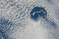 ISS-40 Guadalupe Island and cloud vortices.jpg 4,256 × 2,832; 1.62 MB
-
 ISS-55 Southern California and Baja California, Mexico.jpg 5,568 × 3,712; 1.26 MB
-
 ISS020-E-7022 - View of Mexico.jpg 4,256 × 2,832; 836 KB
-
 ISS023-E-6462 - View of Earth.jpg 4,288 × 2,848; 831 KB
-
 ISS023-E-6474 - View of Earth.jpg 4,288 × 2,848; 740 KB
-
 ISS040-E-16032 - View of Mexico.jpg 4,256 × 2,832; 1.18 MB
-
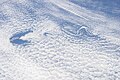
 Van Karman Vortices off Guadalupe Island (MODIS 2021-05-10).jpg 1,923 × 1,549; 323 KB
-
 Von Kármán Vortices Form Off Guadalupe Island (NESDIS 2019-05-14).jpg 1,280 × 720; 109 KB
-
 Von Kármán Vortices in the Clouds off Guadalupe Island (MODIS 2022-05-19).jpg 2,658 × 2,019; 719 KB
-
 Vortices behind Isla Gudalupe (MODIS).jpg 2,126 × 1,442; 351 KB
.jpg)
.jpg)
.jpg)


.jpg)
.jpg)
.jpg)
.jpg)