File:Valentia Edetanorum, Plebs of Cid WDL7329.pdf
Jump to navigation
Jump to search

Size of this JPG preview of this PDF file: 415 × 599 pixels. Other resolutions: 166 × 240 pixels | 332 × 480 pixels | 900 × 1,300 pixels.

Original file (900 × 1,300 pixels, file size: 4.11 MB, MIME type: application/pdf, 4 pages)
Captions
Captions
Add a one-line explanation of what this file represents
Summary
[edit]| Author |
Русский: Тоска, Томас Висенте, 1651-1723 гг.
Français : Tosca, Tomás Vicente, 1651-1723
English: Tosca, Tomás Vicente, 1651-1723
中文:托斯卡, 托马斯·维森特,1651-1723 年
Português: Tosca, Tomás Vicente, 1651-1723
العربية: توسكا، توماس فيسنتي، 1651-1723
Español: Tosca, Tomás Vicente, 1651-1723 |
| Title |
Русский: Valentia Edetanorum, народ Сида
Français : Valentia Edetanorum, village du Cid
English: Valentia Edetanorum, Plebs of Cid
中文:巴伦西亚伊德塔诺里,熙德的子民
Português: Valentia Edetanorum, plebe de Cid
العربية: فالنتينا إديتانورم، خرائط السيد
Español: Valentia Edetanorum, vulgo del Cid |
| Description |
Русский: Эта древняя карта города Валенсии, имеющая большое культурное значение, была изготовлена на четырех листах Томасом Висенте Тоской (1651–1723 гг.), валенсийским священником, ученым, математиком, картографом и теологом, основателем группы "Novatores" – научного общества, созданного с целью критического анализа и обновления преобладавших в научном мире идей и методик. Наиболее значимой работой отца Тоски был "Compendio Matemático" ("Математический компендиум"), девятитомный труд, написанный им в 1707–1715 гг., который, наряду с математикой и геометрией, охватывал такие дисциплины, как астрономия, география, искусство судовождения, военная архитектура, оптика и законы перспективы. Этот труд имел большой успех, было выпущено несколько изданий и выполнены переводы на другие языки, включая немецкий, французский и итальянский. Кроме того, Тоска сконструировал и построил большой географический глобус. Составленная Тоской карта Валенсии, выпущенная в 1704 г., содержит подробный план города с изображением общественных зданий и частных домов, улиц, площадей и прочих городских достопримечательностей. В левом верхнем углу карты помещено созданное Хосе Фортеа аллегорическое изображение города в виде женщины, которая одной рукой опирается на герб города, а в другой руке держит факел; на как бы выходящей из сердца ленте помещен девиз "Ardet et lucet intus et foris" ("Горит и озаряет изнутри и снаружи"). В нижнем углу в большом барочном картуше, украшенном символами математических дисциплин и изящных искусств, помещены условные обозначения карты или "Пояснение обозначений". В пояснении приведен длинный перечень приходов, монастырей, школ, больниц, дворцов, домов, рыбных рынков и прочих мест города. Масштаб, указанный на третьем листе, выражен как 1 к 1 200 валенсийским палмам (единица длины, равная 14,7 см).
Français : Cette importante carte de la ville de Valence, sur quatre feuilles, est l'œuvre de Tomas Vicente Tosca (1651-1723), prêtre local, érudit, mathématicien, cartographe et théologien. Il fut le fondateur du groupe Novatores, société scientifique établie dans le but de mettre en cause et renouveler les idées et pratiques dominantes. Le livre le plus important du Père Tosca fut Compendio Matemático (Mathematical compendium), ouvrage en neuf volumes composé entre 1707 et 1715. Outre les mathématiques et la géométrie, cet ouvrage abordait des sujets tels que l'astronomie, la géographie, le matelotage, l'architecture militaire, l'optique et la perspective. Le succès de cet ouvrage fut tel que plusieurs éditions furent réalisées. Il fut également traduit en d'autres langues, y compris l'allemand, le français et l'italien. Tosca conçut et construisit également un grand globe terrestre. La carte de Valence de Tosca, élaborée en 1704, propose des vues détaillées d'immeubles publics et privés, de rues, de places et autres caractéristiques de la ville. Le bord supérieur gauche de la carte montre une allégorie de la ville par Joseph Fortea dans laquelle une femme tient les armoiries de la ville et porte une torche dans sa main ; un ruban sort de son cœur avec la légende Ardet et lucet intus et foris (Brûle et brille à l'intérieur et à l'extérieur). Dans le coin inférieur, dans un grand cartouche baroque décoré de motifs relatifs aux mathématiques et aux beaux-arts se trouve la clé de la carte ou « l'Explication des notes ». Il contient une longue liste de paroisses, couvents, écoles, hôpitaux, palais, maisons, poissonneries et autres endroits de la ville. L'échelle, sur la troisième feuille, est exprimée ainsi : un sur 1 200 paumes valenciennes (unité de mesure égale à 14,7 centimètres).
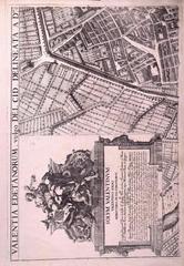
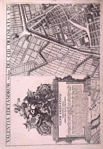
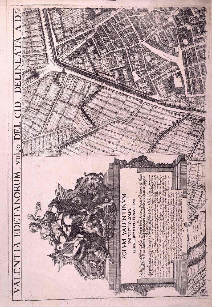
English: This important early map, on four sheets, of the city of Valencia is by Tomas Vicente Tosca (1651–1723), a local priest, scholar, mathematician, cartographer, and theologian, who was a founder of the Novatores group, a scientific society established with the aim of challenging and renewing prevailing ideas and practices. Father Tosca’s most important book was Compendio Matemático (Mathematical compendium), a nine-volume work composed in 1707–15 that covered, in addition to mathematics and geometry, such subjects as astronomy, geography, seamanship, military architecture, optics, and perspective. The success of this work was such that several editions were made and it was translated into other languages, including German, French, and Italian. Tosca also designed and built a large geographic globe. Tosca’s map of Valencia, produced in 1704, provides detailed views of public and private buildings, streets, squares, and other features of the city. The top left corner of the map shows an allegory of the city, by Joseph Fortea, in which the matron holds the coat of arms of the city and carries a torch in her hand; a ribbon protrudes from her heart with the legend Ardet et lucet intus et foris (Burns and shines within and without). In the bottom corner, in a large baroque cartouche decorated with patterns relating to mathematics and the fine arts, is the key to the map or "Explanation of the notes." It has a long list of parishes, convents, schools, hospitals, palaces, houses, fish markets, and other places in the city. The scale, on the third sheet, is expressed as one to 1,200 Valencian palms (a unit of length equal to 14.7 centimeters).
中文:这是一份重要的早期巴伦西亚城地图,共四个折页,绘制者是托马斯·维森特·托斯卡(Tomas Vicente Tosca,1651–1723 年)。他是当地的神父、学者、数学家、制图家和神学家,也是维新派创始人。维新派是一个科学社团,旨在挑战和创新盛行的思想和做法。托斯卡神父最重要的作品是 Compendio Matemático(《数学汇编》),共有九卷,撰写于 1707–1715 年,内容除涉及数学和几何外,还涵盖天文、地理、航海、军用工事、光学以及透视法等学科。该著作获得了很大的成功,先后出版了多个版本,并被翻译成德语、法语、意大利语等多种语言。此外,托斯卡还设计并制作了大型的地球仪。托斯卡的这幅巴伦西亚地图制作于 1704 年,详尽描绘了公共和私人建筑、街道、广场以及城市的其他面貌。地图左上角展示的是约瑟夫·弗尔迪亚 (Joseph Fortea) 以这座城市为背景所写的寓言故事。其中,一位老夫人握着该城市的盾形纹章,手持火炬;一条缎带从她的心脏伸出,展现 Ardet et lucet intus et foris (身体内外燃烧、火光闪耀)的传奇景象。地图下角饰有数学和美术图案的巴洛克式漩涡花饰是解读地图的钥匙,即对地图的“解释说明”。地图上还有一个很长的列表,列出了教区、修道院、学校、医院、宫殿、房屋、鱼市等地方。比例尺位于第三个折页上,以 1:1200 巴伦西亚帕姆斯(一种长度单位,相当于 14.7 厘米)显示。
Português: Este mapa antigo importante, em quatro folhas, da cidade de Valência, é de Tomas Vicente Tosca (1651-1723), um padre local, erudito, matemático, cartógrafo e teólogo, que foi um dos fundadores do grupo Novatores, uma sociedade científica estabelecida com o objetivo de desafiar e renovar ideias e práticas predominantes. O livro mais importante do padre Tosca foi o Compendio Matemático (Compêndio matemático), uma obra de nove volumes composta em 1707-1715 que abrangia, além da matemática e da geometria, temas como astronomia, geografia, marinharia, arquitetura militar, ótica e perspectiva. O sucesso desta obra foi tão grande que várias edições foram produzidas e traduzidas para outros idiomas, incluindo o alemão, o francês e o italiano. Tosca também projetou e construiu um grande globo geográfico. O mapa de Tosca de Valência, produzido em 1704, oferece uma vista detalhada de edifícios públicos e particulares, ruas, praças e outros detalhes da cidade. O canto superior esquerdo do mapa mostra uma alegoria da cidade, de José Fortea, em que a matrona segura o brasão de armas da cidade e carrega uma tocha na mão, uma fita se projeta a partir de seu coração com a legenda Ardet et lucet intus et foris (Queima e brilha por dentro e por fora). No canto inferior, em uma grande cártula barroca decorada com padrões relativos à matemática e às artes plásticas, está a chave do mapa ou "Explicação das notas". Ela possui uma longa lista de paróquias, conventos, escolas, hospitais, palácios, casas, mercados de peixe e outros locais na cidade. A escala, na terceira folha, é expressa em um para 1.200 palmos valencianos (uma unidade de comprimento igual à 14,7 centímetros).
العربية: إن هذه الخريطة القديمة المهمة التي جاءت على أربع ورقات لمدينة فالنسيا من إعداد توماس فيسنتي توسكا (1651-1723)، وقد كان كاهنًا وعالمًا بالدين وعالمًا بالرياضيات ورسامًا للخرائط وعالمًا باللاهوت، وكان مؤسس مجموعة النوفاتورز، وهي مجتمع علمي تم تأسيسه بهدف تحدي وتجديد الأفكار والممارسات السائدة. وكان كتاب الملخص الرياضي أهم كتاب للبابا توسكا، وهو كتاب من تسع مجلدات تم تأليفه في الفترة ما بين عامي 1707 و1715، واشتمل الكتاب بالإضافة إلى الرياضيات والهندسة على مواد أخرى، مثل علم الفلك وعلم الجغرافيا وفن الملاحة والعمارة العسكرية وعلم البصريات والرسم المنظوري. وتمثل نجاح هذا العمل في أنه تم نشر عدة طبعات له وتمت ترجمته إلى أكثر من لغة من بينها الألمانية والفرنسية والإيطالية. كما قام توسكا بتصميم وبناء كرة أرضية جغرافية كبيرة. أما بالنسبة إلى خريطة توسكا لمدينة فالنسيا، والتي تم إنتاجها في عام 1704، فهي تُظهر مشاهد تفصيلية لمبانٍ وشوارع وميادين عامة وخاصة وملامح أخرى للمدينة. تُظهر الزاوية العلوية اليسرى من الخريطة شعار المدينة الذي رسمه جوزيف فورتي، وهو عبارة عن مربية تمسك شعار المدينة وتحمل شعلة في يدها؛ ويخرج من قلبها شريط مع الأسطورة يتوهج ويتألق في الداخل والخارج. في الزاوية السفلية، هناك خرطوش باروكي كبير مزخرف بأنماط تتعلق بالرياضيات والفنون الجميلة، وهو عبارة عن مفتاح الخريطة أو "شرح للملاحظات." وتحتوي على قائمة طويلة من الأبريشات وديار الرهبنة والمدارس والمستشفيات والقصور والمنازل وأسواق السمك وأماكن أخرى في المدينة. يتم التعبير عن مقياس رسم الخريطة في الورقة الثالثة بتدرج يتراوح ما بين نخلة فالنسية واحدة حتى 1200 نخلة فالنسية (وحدة قياس طولها يساوي 14.7 سنتيمتر).
Español: Este importante mapa antiguo, en cuatro hojas, de la ciudad de Valencia es de Tomás Vicente Tosca (1651-1723), cura, erudito, matemático, cartógrafo y teólogo local, que fue uno de los fundadores del grupo Novatores, una sociedad científica establecida con el propósito de desafiar y renovar las ideas y prácticas existentes. El libro más importante del padre Tosca fue Compendio Matemático, una obra de nueve volúmenes que compuso entre 1707 y 1715 donde, además de la matemática y la geometría, se estudian otros temas como la astronomía, la geografía, la náutica, la arquitectura militar, la óptica y la perspectiva. El éxito de esta obra fue tan grande que se hicieron varias ediciones y se tradujo a otros idiomas como el alemán, el francés y el italiano. Tosca también diseño y construyó un gran globo geográfico. El mapa de Valencia que hizo Tosca en 1704 aporta vistas detalladas de edificios públicos y privados, calles, plazas y otras características de la ciudad. En la esquina superior derecha del mapa hay una alegoría de la ciudad, obra de José Fortea, en la que una matrona sostiene el escudo de la ciudad y lleva en la mano una antorcha; del corazón sale un lazo con la leyenda: Ardet et lucet intus et foris (Arde y brilla adentro y afuera). En la esquina inferior izquierda, dentro de una gran orla barroca decorada con motivos alusivos a la matemática y las bellas artes, se encuentra la clave del mapa o «Explicación de las notas». Tiene una larga lista de parroquias, conventos, colegios, hospitales, palacios, casas, lonjas y otros lugares de la ciudad. La escala, en la tercera hoja, está expresada en uno a 1200 palmos valencianos (una unidad de medida equivalente a 14,7 centímetros). |
| Date | 1705 |
| Medium |
Русский: Карты
Français : Cartes
English: Maps
中文:地图
Português: Mapas
العربية: خرائط
Español: Mapas |
| Dimensions |
English: 1 plan on 4 sheets: engraving, 102 x 146 centimeters in sheets of 49 x 71 centimeters |
| Collection |
Русский: Национальная библиотека Испании
Français : Bibliothèque nationale d'Espagne
English: National Library of Spain
中文:西班牙国家图书馆
Português: Biblioteca Nacional da Espanha
العربية: مكتبة إسبانيا الوطنية
Español: Biblioteca Nacional de España |
| Place of creation |
Русский: Валенсия
Français : Valence
English: Valencia
中文:巴伦西亚
Português: Valência
العربية: فالنسيا
Español: Valencia |
| Notes |
Original language title: Valentia edetanorum, vulgo del Cid Русский: Масштаб 1:1 800. Изображение рельефа штрихами.
Français : Échelle 1:1 800. Relief représenté par des hachures.
English: Scale 1:1,800. Relief shown by hachures.
中文:比例尺:1:1,800。地势用晕滃线指示。
Português: Escala 1:1.800. Relevo destacado por hachuras.
العربية: مقياس الرسم 1:1.800. التضاريس موضحة باستخدام الخطوط المتوازية.
Español: Escala 1:1800. Se muestra el relieve por sombreado. |
| References | http://hdl.loc.gov/loc.wdl/spmabn.7329 |
| Source/Photographer |
http://dl.wdl.org/7329/service/7329.pdf
|
Licensing
[edit]|
This is a faithful photographic reproduction of a two-dimensional, public domain work of art. The work of art itself is in the public domain for the following reason:
The official position taken by the Wikimedia Foundation is that "faithful reproductions of two-dimensional public domain works of art are public domain".
This photographic reproduction is therefore also considered to be in the public domain in the United States. In other jurisdictions, re-use of this content may be restricted; see Reuse of PD-Art photographs for details. | ||||
File history
Click on a date/time to view the file as it appeared at that time.
| Date/Time | Thumbnail | Dimensions | User | Comment | |
|---|---|---|---|---|---|
| current | 23:03, 11 March 2014 |  | 900 × 1,300, 4 pages (4.11 MB) | Fæ (talk | contribs) | =={{int:filedesc}}== {{Artwork |artist = |author ={{ru|1=Тоска, Томас Висенте, 1651-1723 гг.}} {{fr|1=Tosca, Tomás Vicente, 1651-1723}} {{en|1=Tosca, Tomás Vicente, 1651-1723}} {{zh|1=托斯卡, 托马斯·维森特,1651-1723 �... |
You cannot overwrite this file.
File usage on Commons
The following page uses this file: