File:VIIRS First Light - NASA Earth Observatory.jpg
Original file (720 × 720 pixels, file size: 271 KB, MIME type: image/jpeg)
Captions
Captions
Summary
[edit]
| Description |
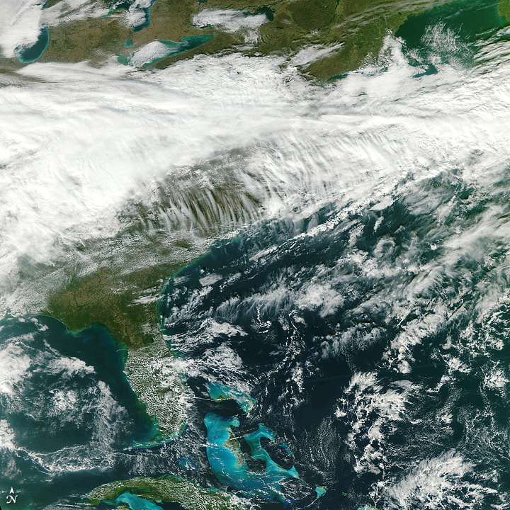
To download the full resolution and other files go to: earthobservatory.nasa.gov/IOTD/view.php?id=76481&src=... The Visible Infrared Imager Radiometer Suite (VIIRS) on the United States’ newest Earth-observing satellite, NPP, acquired its first measurements on November 21, 2011. This image above shows a broad swath of eastern North America from the Great Lakes to Cuba. The large image (downloadable below the main image) shows the full scene from Hudson Bay to the northern coast of Venezuela. VIIRS collects radiometric imagery in visible and infrared wavelengths of the Earth's land, atmosphere, and oceans. “This image is a next step forward in the success of VIIRS and the NPP mission,” said James Gleason, project scientist for the National Polar-orbiting Operational Environmental Satellite System Preparatory Project at NASA's Goddard Space Flight Center. NPP was launched on October 28, 2011, and recently reached its final orbit at an altitude of 512 miles (824 kilometers). The satellite operations team has powered on all of the instruments, and the spacecraft is now traveling around Earth at 16,640 miles per hour (eight kilometers per second). VIIRS is the largest instrument onboard NPP, weighing in at 556 pounds (252 kilograms). Its data, collected from 22 channels across the electromagnetic spectrum, will be used to observe the Earth's surface including fires, ice, ocean color, vegetation, clouds, and land and sea surface temperatures. The NPP Team at the Space Science and Engineering Center, University of Wisconsin–Madison, created the image above using three channels (red, green and blue) of VIIRS data. The original data—taken from the first full NPP orbit with VIIRS turned on—were processed at the NOAA Satellite Operations Facility. “The task now for the science community is to evaluate VIIRS performance and determine the accuracy of its data products,” said Chris Justice, a professor of geography at the University of Maryland, who will be using VIIRS data in his research. “These long-term data records are critical in monitoring how the Earth's surface is changing - either from human activity or through climate change.” Image by the NASA/NPP Team at the Space Science and Engineering Center, University of Wisconsin–Madison. Caption by Aries Keck and Michael Carlowicz. |
| Date | |
| Source | VIIRS First Light |
| Author | NASA's Earth Observatory |
| Camera location | | View this and other nearby images on: OpenStreetMap |
|---|
Licensing
[edit]
- You are free:
- to share – to copy, distribute and transmit the work
- to remix – to adapt the work
- Under the following conditions:
- attribution – You must give appropriate credit, provide a link to the license, and indicate if changes were made. You may do so in any reasonable manner, but not in any way that suggests the licensor endorses you or your use.
| This image was originally posted to Flickr by NASA Earth Observatory at https://www.flickr.com/photos/68824346@N02/6389520921. It was reviewed on 2 July 2012 by FlickreviewR and was confirmed to be licensed under the terms of the cc-by-2.0. |
File history
Click on a date/time to view the file as it appeared at that time.
| Date/Time | Thumbnail | Dimensions | User | Comment | |
|---|---|---|---|---|---|
| current | 17:18, 2 July 2012 | | 720 × 720 (271 KB) | Dzlinker (talk | contribs) | == {{int:filedesc}} == {{Information |Description=To download the full resolution and other files go to: [http://earthobservatory.nasa.gov/IOTD/view.php?id=76481&src=flickr earthobservatory.nasa.gov/IOTD/view.php?id=76481&src=...] The Visible Infrared... |
You cannot overwrite this file.
File usage on Commons
There are no pages that use this file.